Download
1 / 25
250 likes | 414 Vues
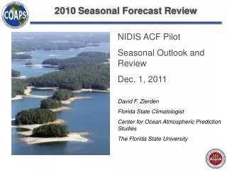
2010 Seasonal Forecast Review. NIDIS ACF Pilot Seasonal Outlook and Review Dec. 1, 2011 David F. Zierden Florida State Climatologist Center for Ocean Atmospheric Prediction Studies The Florida State University. Pacific Ocean 2010 – Strong La Niña.

E N D
2010 Seasonal Forecast Review NIDIS ACF Pilot Seasonal Outlook and Review Dec. 1, 2011 David F. Zierden Florida State Climatologist Center for Ocean Atmospheric Prediction Studies The Florida State University
Niño Region SST Departures (oC) Recent Evolution The latest weekly SST departures (Nov. 2010) are: Niño 4 -1.2ºC Niño 3.4 -1.3ºC Niño 3 -1.5ºC Niño 1+2 -2.0ºC
Multivariate ENSO Index (MEI) • Based on several variables: • SST’s • Surface pressure • Winds • Air temperature • Cloudiness
ENSO Predictions CFS Ensemble
Strength Versus Duration (MEI 1870-2005) 2010 started in June-July: expected demise between Jan-Feb 2012 and Nov-Dec 2013
Multivariate ENSO Index: recent and six strong La Niña events
La Niña Forecast Review • Strong La Niña in place during last the last outlook forum (Nov., 2011). • Persistence and ENSO models correctly forecasted moderate to strong La Niña through Spring (MAM) of 2011. • Models have little skill predicting past the “spring barrier”. • Correlation of strength versus duration and analog predictions indicated good chance of lasting past summer of 2011 (Klaus Wolter). • SST’s and MEI returned to neutral during summer of 2011, only for La Niña to re-emerge in the Fall of 2011.
Typical US Temperature, Precipitation and Jet Stream Patterns during La Niña Winters
Precipitation Forecast Winter Correlation Plot La Nina Composite Precipitation
Precipitation Forecast Review • Winter precipitation is highly correlated with the ENSO cycle in Florida, South and Central Georgia, and South Alabama. • A good likelihood of below normal rainfall was forecast for these areas. • Below normal rainfall was observed farther north than the forecast/composites indicated, Florida was less dry than forecasted. • Spring rainfall patterns looked more like typical La Nina winters, with enhanced dryness in Georgia, Florida, and Alabama and storm tracks through the Mississippi and Ohio valleys.
Temperature Forecast – Did it Verify? Winter 2010/2011 (DJF)
Observed Winter Temperature (2010/2011) December 2010 Dec. – Feb., 2011
North Atlantic Oscillation • NAO is large-scale pattern characterized by the pressure difference between the Azors and the Iceland. • Negative phase characterized by weaker subtropical high and weaker Icelandic low. • Dominant mode of intraseasonal climate variability in Western Europe and U.S. east coast. • Negative phase corresponds to more cold air outbreaks and snowy weather for the U.S. east Coast. • More an indicator of the large scale pattern than a cause or predictor.
Temperature Forecast Review • ENSO composites and CPC forecasted increased likelihood of a warm winter. • Strong and persistent negative phase of the NAO (AO) lead to unusually cold December in the Southeast. • Chill accumulation was well above normal for most of the Southeast. • More typical La Niña temperature patterns established themselves after the NAO returned to normal. • Spring temperatures across the Southern U.S. were in line with typical La Niña patterns.
Drought Monitor - Initial Conditions Nov. 16, 2010 Unusually dry July and August of 2010 initiates drought in South Alabama and South Georgia.
Observed Evolution of Drought Nov. 16, 2010 March 1, 2011 May 31, 2011
Forecast Summary • La Niña correctly forecasted to remain strong through spring of 2011, correctly forecasted to last at least two years. • Winter rainfall correctly forecasted below normal, spring rainfall was drier than expected. • Winter temperatures were forecast to be warm, but were near-record cold for early winter. Spring temperatures in line with La Niña. • Drought correctly forecasted to persist or intensify.