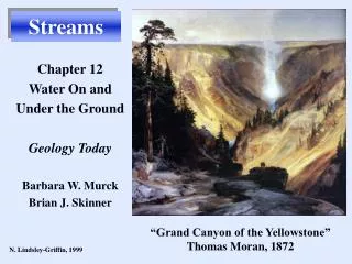
Streams
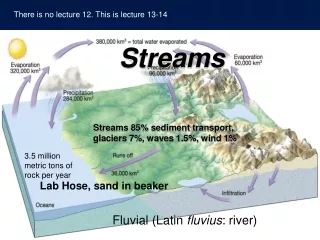
Streams. Streams 85% sediment transport, glaciers 7%, waves 1.5%, wind 1%. Lab Hose, sand in beaker. Fluvial (Latin fluvius : river). Evapotranspiration and Drought.


Streams
E N D
Presentation Transcript
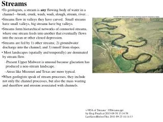
Streams Streams 85% sediment transport, glaciers 7%, waves 1.5%, wind 1% Lab Hose, sand in beaker Fluvial (Latin fluvius: river)
Evapotranspiration and Drought • Globally, something like 64 percent of precipitation occurs over land as a result of evapo-transpiration from lakes and wetlands and dense vegetation, in particular forests pumping groundwater held in the soils into the air.
Sources of Earth’s water (saltwater) freshwater
Infiltration • Infiltration is controlled by • Intensity and duration of rainfall • Soil texture • Slope of the land • Nature of the vegetative cover • Runoff occurs in excess when soil is saturated or when slope is too great.
Streamflow • Factors that determine velocity • Gradient, or slope • Channel characteristics including shape, size, and roughness • Discharge – the volume of water moving past a given point in a certain amount of time
Stream Changes • Changes from upstream to downstream • Factors that decrease downstream • A. Longitudinal Profile is the side-view of a stream • From head (headwaters) to mouth of stream profile flattens out • B. So gradient (slope) decreases downstream • C. channel roughness (grain size) also decreases downstream • Factors that increase downstream • A. Velocity • B. Discharge • C. Channel size all get larger
Longitudinal profile of a stream Drainage Divide Tributaries Stream capture, decapitation Distributaries And Delta Trunk Stream
Base Level • Elevation below which a stream cannot erode • Local and ultimate
Graded Streams Demo: bank collapse, stream cross section reduced Pinched hose demo
Graded Streams • Erosion and Deposition Equal • When local conditions in a graded stream are disrupted, velocity changes. • Original conditions are restored. • DEMOS • Pinched hose demo, change in velocity at restrictions • Hose and sand demo: faster water is better at erosion
More important definitions Stream - Sediment Terminology • Transported material is called sediment load • Types of load • Dissolved load - ions in solution • Suspended load - fine clays, etc • Bed load Moves during flood - high velocity Sandy Portion – Saltation (bouncing) Boulders – Traction (rolling) • Capacity –maximum load stream transports • Competence – Largest particles it can move • Proportional to velocity squared
Suspended load - confluence Green & Colorado Rivers in Canyonlands, Utah
Competence • Maximum particle size a stream transports • Proportional to velocity squared –K.E. • Depositionof sediment by a stream • Caused by a decrease in velocity • Competence is reduced • Sediment begins to drop out
1. Narrow valleys uplift or drop in base level • V-shaped • Downcutting toward base level • Can include rapids and waterfalls • Straighter streams • Typical of steep slopes in uplifted areas
An Alluvial Fan in Death Valley Sudden drop in competence • Alluvial fans • Develop where a high-gradient stream leaves a narrow valley and spreads out onto a broad plain • Slopes outward in a broad arc
2. Wide valleys • Meanders "Meandering Stream" • Cut bank and point bar • Cutoffs and oxbow lakes • Floodplains, either: • Erosional floodplains • Depositional floodplains
Erosion and deposition along a meandering stream Discussion: Crack the whip Floodplain Levee Meanders get more extreme with time. Deposition at point bar keeps up with erosion at cutbank
Deposition of sediment by a meandering stream • Channel deposits • Point bars cover bed load as meandering stream’s channel loops move • Floodplain deposits cover point bar • form parallel to the stream channel by successive floods over many years Natural Levees
Channel moves in direction of cutbank Pointbar advances as crossbed drapes Cut off loops silt up; called oxbow lakes Old cut-off loop fills with mud, an oxbow lake Meandering Stream OxBow Floodplain http://hays.outcrop.org/gallery/rivers/arid_meander?full=1
Point Bar Sequence from Meandering Stream Fines of Floodplain Crossbeds of Point Bar Gravel of bed Erosion
Formation of natural levees by flooding Meandering Stream Flood over banks, sediment carrying water into wide area, greater drag, lower velocity, load drops
Delaware Water Gap • Incised meanders • Meanders in steep, narrow valleys • Caused by a drop in base level or uplift of region
Stream Terraces River meanders across floodplain. Base level drops, or region uplifts. River cuts into bed, cutoffs abandon large loops, leaving oxbows Stream less wide, uses narrower floodplain Old floodplain is a terrace
3. Braided Streams • Occur where bed load is very high. Often big boulders in the stream. At headwaters and near glaciers • Many channels because flow is intermittent/seasonal - old channel banks collapse in dry season , redirect flow next flood season • "mid-channel bars" between channels
Deltas • Occur where stream hits slow water • Velocity, competence, bedload drop • Deposits build out into lake or sheltered sea, extending the length of the river • Consists of three types of beds Topset beds Foreset beds Bottomset beds
Deltas have strata deposited in a characteristic geometry Topsets, Foresets and Bottomsets Actually much more complex: many distributary channel deposits
River delta distributary channels change location with time General trend: Delta builds Seaward. If Floodwaters happen to reach the sea via a new shortcut, they flow by the shorter (steeper) path cutting a new channel, abandon old
Part 2 - Groundwater • water found in sediment, plus narrow fractures in bedrock • Groundwater is the largest usable reservoir of fresh water available to humans, but much more in glacier ice
Distribution of Groundwater • Water table is the upper limit of saturation • Variations in the water table • Depth is highly variable • Varies seasonally and from year to year • Shape is usually similar to surface topography Groundwater table generally follows topography
Factors influencing movement of groundwater - 1 • Porosity – Volume of Pore Space • Permeability – the ability of a material to transmit a fluid through pore space High Permeability Low Permeability
Factors influencing movement of groundwater - 2 • Aquifer – a permeable rock layer or a sediment that transmits groundwater freely (such as sands and gravels) • Aquitard – an impermeable layer that hinders water movement (such as mudstone - clay)
Springs may result from a perched water table Aquifer Rollie’s Well
GEYSERS • Intermittent hot springs • Water erupts with great force • Occur where extensive underground chambers exist near hot igneous rock • Groundwater heats, expands, changes to steam, and erupts
Wells To obtain a continuous supply of water, we must cut down below the water table
Sometimes a pump is not needed Demo: Artesian Discussion: Quicksand
Hydraulic head and urban water supplies Just like an artesian, saves money Towns pump the water up to their water tank at night, when electricity is cheap. Artificial artesian.
Excessive Pumping of wells can causeDrawdown (lowering) of the water tableCone of depression in the water tableMay cause dry well Discharge exceeds recharge
Saltwater contamination due to excessive well pumping WildwoodCrest
Well design requires knowledge of local geology Aquatard Don’t fire the town engineer!
Geologic work of groundwater • Acidic groundwater dissolves limestone • Groundwater is often mildly acidic • Contains weak carbonic acid, H2CO3 which forms when carbon dioxide from the air dissolves in cloud water droplets • Groundwater becomes more acidic from decaying plants "Humic Acid" • Acid dissolves calcite in limestone, releasing CO2 gas CaCO3 + 2H+ ↔ Ca++ + H2O + CO2 (g) The reaction reverses, and calcite is deposited, if CO2 gas concentration gets high
Geologic work of groundwater • Caverns • Features found within caverns • Composed of dripstone (travertine) • Calcite deposited as dripping water evaporates • Includes stalactites (hanging from the ceiling) and stalagmites (form on the floor of a cavern) CaCO3 + 2H+ ↔ Ca++ + H2O + CO2 (g) Reaction reverses, and calcite is deposited, if CO2 gas concentration gets high
Karst Topography • Sinkhole or sinks (formed by groundwater slowly dissolving the bedrock often accompanied by collapse) • Disappearing (aka sinking) streams
Stream incision, cave development and karst topography
In Xanadu did Kubla KhanA stately pleasure-dome decree:Where Alph, the sacred river, ranThrough caverns measureless to man Down to a sunless sea. Xanadu, by Samuel Taylor Coleridge
Solution and Collapse Sinkholes Winter Park, Florida. 1981 Porsche Dealership and Pool Don’t fire the town’s engineer! Water weighs 8.34 pounds per gallon, and is incompressible Limestone weighs 5744 pounds/ m3 Pool 50x25x2 meters