Enhancing Public Transportation Services Through Data Coordination and Real-Time Information
In FY2012, a demonstration showcased the integration of data from multiple public transportation agencies to improve services in urban areas. By coordinating real-time information from railways and buses, new support systems were developed for vulnerable users, including the elderly and disabled. Innovations included real-time operation updates, next-generation facility information, and voice assistance for visually impaired users. These initiatives involved collaboration among various organizations and highlighted the benefits of open data access and sharing.

Enhancing Public Transportation Services Through Data Coordination and Real-Time Information
E N D
Presentation Transcript
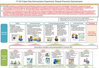
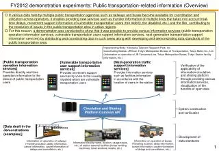
FY2012 demonstration experiments: Public transportation-related information (Overview) ○If various data held by multiple public transportation agencies such as railways and buses become available for coordination and utilization across operators, it enables providing new services such as transfer information of multiple lines that takes into account real-time delays, movement support information of vulnerable transportation users (the elderly, the disabled, etc.) and the like, contributing to the resolution of issues in the public transportation area in urban regions. ○ For this reason, a demonstration was conducted to show that it was possible to provide various information services (public transportation operation information services, vulnerable transportation users support information services, next-generation transportation support information services) by distributing and coordinating data in such areas along withdeveloping and demonstrating data standards of the public transportation area. Implementing Body: Yokosuka Telecom Research Park, Inc. Coordinating Bodies: JR East, Tokyo Metropolitan Bureau of Transportation, Tokyo Metro Co., Ltd. (Information on operation of JR Yamanote Line, Tokyo Metropolitan Buses, Tokyo Station facility information, etc.) [Public transportation operation information services]Provides directly real-time operation information to the device of public transportation users [Next-generation traffic support information services]Provides information services such as facilities information in accordance with the location of users in the station [Vulnerable transportation user support information services]Provides movement support services by voice to the visually impaired whom are vulnerable transportation users Verification of the applicability of information circulation and sharing platformthrough providing various information services, visualization of the benefits of open data Circulation and Sharing PlatformCommonAPI System construction and verification [Data dealt in the demonstrations (examples)] Development of data standards Information on operation of buses (Traveling location, delay information, cancel information, cause information of delays and cancellation, etc.) Information on operation of railways (Traveling location, delay information, cancel information, cause information of delays and cancellation, etc.) Information (facility name, location, usage status, etc.) of station terminal facilities (ticket vending machines, ticket windows, kiosks, etc.)
FY2012 demonstration experiments: Public transportation-related information (Applications [1]) As of 9:51 pm Public transportation information Transit information • ■Public transportation operation information service "Dokoshiru" • Shows real-time location information and timetable information of the train (JR Yamanote Line) and Tokyo Metropolitan Buses (within 23 wards) by obtaining and using the Information Circulation and Sharing Platform Common API • Also shows delay information of each of JR lines in the Tokyo metropolitan area, all of Tokyo Metro • lines, and the entire Tokyo Metropolitan • Subway lines • Released on Google Play in March Information on bus and train positions are estimates made by this system. Information on bus and train positions are estimates made by this system. Shows delay information Shows on the map train and bus location information estimated from real-time operation information Chuo Line express train Train in service 8:48 pm February 1, 2013 • ■ Next-generation transportation support information service "Kokoshiru Tokyo Station" • Estimates the current position of the user in Tokyo Station and displays it on the map, then shows facilities information (stores, ticket vending machines, ticket gates, toilets, lockers, etc.) obtained through using the Information Circulation and Sharing PlatformCommon API by coordinating with the current location of the user • The "Kokoshiru Assistant" function shows convenient surrounding facilities, in-station shops, toilet locations based on the time remaining until departure • of Shinkansen and the current • location • Released on Google Play in March Due to the effects of a train inspection at Tachikawa Station, there is a partial delay in Chuo Line express trains traveling into and out of Tokyo. North exit, Shimbashi Station – Nishi-Shimbashi 1 chome "Dokoshiru" screen examples Kokoshiru Assistant Kokoshiru search Shows station map Kokoshiru Assistant Enter keyword Depart at 11:30 Shopping › food, beverages Introduces recommended spots from the time remaining until departure and the current location (for example, introduces a take-out lunch spot near ticket gates of if little time is left until departure) No reservation 18 minutes until departure. Walk through Bay Road for approximately 15 minutes and head toward the Yaesu exit. Platform Map of Shinkansen bullet train ticket area Station box lunch shop “Matsuri” Are you ready to go? • ■ Vulnerable transportation users support information service • Obtains expected arrival time and delay information of Tokyo Metropolitan Buses (within 23 wards) by the Information Circulation and Sharing PlatformCommon API and notifies by voice to the visually impaired Tokyo Hyakka Station box lunch shop “Matsuri” Lavatory (Shinkansen central transfer gate) Lavatory (Shinkansen south transfer gate) "Kokoshiru Tokyo Station" screen examples
FY2012 demonstration experiments:Public transportation-related (Applications [2]) In addition to the three applications (built by a subcontractor) on the previous page, a subcontractor conducted an open recruitment to build applications (open recruitment period: JAN 29 to FEB 15). As a result, 16 applications went live only approximately three weeks after placing the order. [Application examples built through open recruitment] • Torebasa! • Application that collects trains, buses, stations and bus stops near where the current location of the user like a game • OpenData + RailMaping • Visualization of information on operation of Yamanote Line • Electronic compass that guides to a designated facility in Tokyo Station • Shows station status from the route map • HyperTransfer • Transfer guide that takes into account delay information • SuggestingSensor • Application that shows Tokyo Station environment on a proposal basis • Station fix application • Application that places improvement requests on the station • TokyoStationNavi • Application that shows facilities around the NFCtags installed in Tokyo Station by touching them [Achievements and Issues] ○ Based on the common API specification, succeeded in building and implementing APIs and data standards (vocabulary, etc.) in the public transportation area, and verified their effectiveness. ○ When the building of applications that utilize public transportation-related data was openly recruited, various bodies including individuals made proposals. 16 applications were actually built in a short time period of three weeks from the order placement, demonstrating the significance of open data. ○ While JR East and Tokyo Metropolitan Bureau of Transportation and the like participated in the demonstration experiment, it is necessary to continue encouraging open data of a wide variety of public transportation operators including private railways in view of enhancing the convenience of users in the future.
[Reference] Developer website prepared in public transportation demonstration • Prepare a developers' website that offers the following so that it will help the development by application developers • ・ Offer API documentation • ・ Use cases (offer sample codes) to make the API available for immediate use • ・ Forum function • ・ Accept requests for additional functions and improvement (also accept through e-mail) • ・Terms of Use, privacy policy, guidelines Help Personal settings Project Home Logged in Log out My page Search Public Transportation OpenData Move to the project... Overview Documents Activities Forum File News Overview Overview Latest news • This is an open data developer site for public transportation. Please see the relevant sections of the document below for the specifications such as the API needed for development, the terms of use, and the information of guidelines. • Document list • Guideline • Terms and conditions • List of provided target data • - Ministry of Land, Infrastructure and Transport, National and Regional Policy Bureau, National Land Numerical Information Target list • - Target bus stops of Toei bus Target list • - Target bus routes of Toei bus Target list • Railway StationsTarget list • Railway Operationinformation Target list • - Tokyo Station feature information Target list [Release note] 2013-03-08 OpenData Adminadded3 days ago [Failure] Failure to acquire bus travel data Terms and conditions OpenData Admin added4 days ago How to use the website