Soil Profile Evaluations and Comparisons
Soil Profile Evaluations and Comparisons. Location: Pike County, PA Completed By: Will Whitehead For: SWS 5716 Environmental Pedology. Geologic Map of PA. Glacial Till and Outwash. Soil Probe Evaluations Locations. SP-1 along Delaware River SP-2 near Lake Wallenpaupack.


Soil Profile Evaluations and Comparisons
E N D
Presentation Transcript
Soil Profile Evaluations and Comparisons Location: Pike County, PA Completed By: Will Whitehead For: SWS 5716 Environmental Pedology
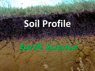
Geologic Map of PA Glacial Till and Outwash
Soil Probe Evaluations Locations. SP-1 along Delaware River SP-2 near Lake Wallenpaupack
24B Delaware fine sandy loam 3-8% slopes
SP-1 Surrounding Landscape Adjacent slope with railroad and road bed. “Foot slope” Wooded area with minimal slope. Floodplain between stone wall and river. “Stream Terrace” Stone Wall between pit and river.
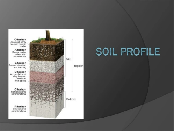
Horizon: Oi Depth: <1 Boundary: A/S Texture: Fibric Color:10YR2/1 Structure: SL/SG Consistence: L Horizon: A Depth: 13 Boundary: C/S Texture: SIL Color:10YR4/1 Structure: MO/SBK Consistence: VFR Horizon: Bw Depth: 58 Boundary: C/S Texture: LS Color:7.5YR5/6 Structure: WK/SBK Consistence: VFR Horizon: Bt1 Depth: 84 Boundary: C/S Texture: SL Color:7.5YR5/4 Structure: MO/SBK Consistence: FR Bridging Horizon: Bt2 Depth: 152 Boundary: C/S Texture: SL Color:7.5YR4/4 Structure: MO/SBK Consistence: FR Bridging Horizon: Bg Depth: 183 Boundary: C/S Texture: LS Color:10YR6/2 Structure: WK/SBK Consistence: FR 25% 7.5YR4/4 S.H.W.T.
321C Lackawanna channery loam 8-15% slopes, extremely stony
SP-2 Surrounding Landscape Wooded hill top. “Upland” Glacial Till. Pit spoils –channery to extremely stony No surface roots.
Horizon: Oi Depth: 10 Boundary: A/S Texture: Fibric Color:10YR2/1 Structure: SL/SG Consistence: L Horizon: A Depth: 25 Boundary: C/S Texture: VCH/ST SIL Color:7.5YR 4/2 Structure: WK/SBK Consistence: VFR Horizon: Bt1 Depth: 46 Boundary: G/S Texture: CH SICL Color:10YR5/4 Structure: WK/SBK Consistence: FR Bridging Horizon: Bt2 Depth: 61 Boundary: C/S Texture: CH SICL Color:10YR5/3 Structure: MO/SBK Consistence: FR Bridging Horizon: C Depth: 76 Boundary: A/S ECH 10YR5/3 Weathered shale bedrock Horizon: R – 76 + Hard shale bedrock – backhoe refusal
Conclusions SP-1 SP-2 Oi A Both soils show signs of illuviation and eluviation. SP-1 is a much younger soil composed of floodplain deposits (transported), while SP-2 is a much older soil formed from weathered bedrock on a ridge scraped clean by glaciers (formed in place). SP-2 shows well defined horizons while SP-1 has poorly defined horizons.