Download
1 / 31
310 likes | 437 Vues
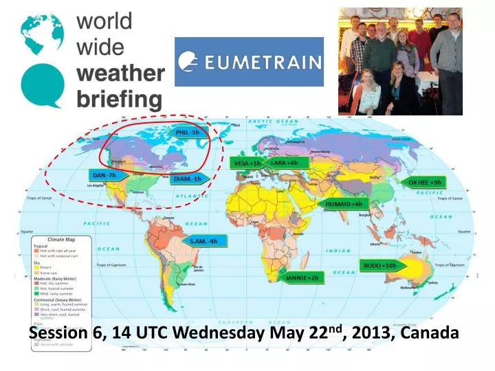
Session 6, 14 UTC Wednesday May 22 nd , 2013, Canada. Phil the Forecaster Chadwick. Retired COMET Liaison Meteorologist from the Meteorological Service of Canada. Artist Philtheforecaster.blogspot.ca. Environmentalist. Just How Big is Canada? .

E N D
Phil the Forecaster Chadwick Retired COMET Liaison Meteorologist from the Meteorological Service of Canada Artist Philtheforecaster.blogspot.ca Environmentalist
Just How Big is Canada? Which is the largest country in the world? Russia Canada United States
Just How Big is Canada? Which country has the longest shoreline in the world? Russia Canada United States
Interesting Canada Canadian motto, A Mari Usque ad Mare, means "From sea to sea” Canada has 9% of world’s renewable fresh water Alert northernmost permanent settlement -63C Feb 3, 1947 Snag Settled by Vikings in 1000 AD “Snorri” First Canadian 50% of world’s bitumen -19C to +22C in one hour, 1962 Why? 21C rise in 4 minutes in 1966 8840 km of undefended border
Just How Big is Canada? Which country has the lowest population density? Russia Canada United States
Canadian population increase to 36 million REMOTESENSING is your best friend in Canada
COMET The Satellite and Radar Palettes
The Art of Phil the Forecaster The Painting Palette Place a star on your favourite image.
Meteorology anArtand a Science A work by Yasuyo Tanaka demonstrating suminagashi – oil and water mixes.
Why remote sensing in northern latitudes? Large areas with few surface observations Mechanically Induced Vortices in a Rotating Tank Requirement to view, analyze and diagnose the entire pattern in order to predict a part of it Long lived and well defined patterns. Why? Two dimensional top-down patterns yield 3-D information. How? Severe weather conditions best viewed safely from a distance… Numerical weather prediction models face huge challenges… All of the above Vortices in a rotating tank: http://www.youtube.com/watch?v=qFIgLbFVo28
Human Skills of Pattern Recognition combined with conceptual models result in situational awareness and atmospheric understanding. The Satellite and Radar Palettes are growing libraries of operationally relevant conceptual models. Visit COMET for more details.
Higher latitude conveyor belts really hang together… Lower latitude circulations tend to mix into oblivion… more challenging to forecast Can you find… ? The North Pole? Santa? A cyclone… low pressure area An anticyclone… high pressure area Vorticity tubes? A warm conveyor belt A jet stream A deformation zone High and cold moist area – precipitation processes? Low and dry area – no precipitation processes? Something interesting? High time and space resolution These 3D conceptual models apply at all time and space scales
3D Water Vapour Weather does not recognize geopolitical boundaries. Canadian weather is the same as Russian weather… Create your own 3D conceptual model of the real atmosphere … new COMET Module coming very soon.
Public Warnings from May 21st, 2013 Heavy snow Heavy rain Frost Marine Severe thunderstorms Lightning Danger within 10 minutes Did Phil shut his computer down? Yes No
Current Weather Related Concerns Spring 2013 Freezing Rain and Ice storms Heavy Snow Heavy Rain Flooding Wild fires Spring Convection Frost Ice storm from late April 2013 – at my home
My hand analysis for Ice Storm 1998 Do you do hand analysis of maps? Place a star… Yes Sometimes No
2 inches of ice accretion on surfaces Happens once or twice a century
Place a star on your favourite image. Current Weather Related Concerns Spring 2013 Freezing Rain and Ice storms Heavy Snow Heavy Rain Flooding Wild fires Spring Convection Frost
Record Values of Snow on Ground, May 2013 Regina's 196 cm (over 6 feet) of snow - a new record for 2013 Which leads to spring flooding…
Preparing for Spring in Canada 2013 Not all Canadians were blaze orange toques… just a majority. I have 4 of them.
Hudson’s Bay is the world’s 2nd largest bay and drains 4 million square kilometres – northward following rivers prone to spring floods. Current Weather Related Concerns Spring 2013 Freezing Rain and Ice storms Heavy Snow Heavy Rain Flooding Wild fires Spring Convection Frost
Current Weather Related Concerns Spring 2013 Freezing Rain and Ice storms Heavy Snow Heavy Rain Flooding Wild fires Spring Convection Frost
Where would you rather be? Current Weather Related Concerns Spring 2013 In the path of the storm. Freezing Rain and Ice storms Heavy Snow Heavy Rain Flooding Wild fires Spring Convection Frost In the remote sensing room. F5 Tornado in Elie, Manitoba on June 22nd, 2007 Vortices of a different scale Remote sensing is the best way to view severe convection.
My personal views only… Place a star on those you agree with… Weather is important to everyoneMeteorologists are the most important part of the forecast cycleI love my profession and going to work! Humans have a skill set not duplicated by any computer Pattern Recognition and conceptual models are great tools that I use Remotely sensed data has terrific time and space resolution… and is getting even better! I just look at NWP…
Thank you to EUMETRAIN ! Thank You from Canada ! Questions? Meteorology: anArtanda Science A work by Yasuyo Tanaka demonstrating suminagashi.