Download
1 / 1
10 likes | 86 Vues
MSIF software fuses two space sensor images to calculate cloud altitudes using advanced algorithms and data visualization techniques developed with Microsoft Visual C++, OpenCV, and OpenGL.

E N D
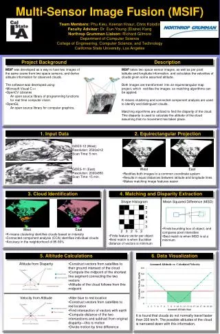
Multi-Sensor Image Fusion (MSIF)Team Members: Phu Kieu, Keenan Knaur, Chris KolodinFaculty Advisor: Dr. Eun-Young (Elaine) KangNorthrop Grumman Liaison: Richard GilmoreDepartment of Computer ScienceCollege of Engineering, Computer Science, and TechnologyCalifornia State University, Los Angeles ? ? Project Background Description • MSIF was developed as a way to fuse two images of the same scene from two space sensors, and derive altitude information for observed clouds. • The software was developed using: • Microsoft Visual C++ • OpenCV Libraries • An open source library of programming functions for real time computer vision. • OpenGL • An open source library for computer graphics. MSIF takes two space sensor images, as well as per pixel latitude and longitude information, and calculates the velocities of clouds given some assumed altitude. Both images are transformed into an equirectangular map project, which rectifies the images so matching algorithms can be applied. K-means clustering and connected component analysis are used to identify and distinguish clouds. Matching algorithms are utilized to find the disparity of the cloud. This disparity is used to calculate the altitude of the cloud assuming that no movement has taken place. 1. Input Data 2. Equirectangular Projection GOES-12 (West) Resolution: 2500x912 Scan Time: 5 min. GOES-11 (East) Resolution: 2000x850 Scan Time: 15 min. West East • Rectifies both images to a common coordinate system • Results in equal distances between latitude and longitude lines • Makes matching image features easier 3. Cloud Identification 4. Matching and Disparity Extraction Shape Histogram Mean Squared Difference (MSD) • Finds bounding box of object, and compares pixel intensities • Best match is when MSD is at a minimum West East • K-means clustering identifies clouds based on intensity • Connected component analysis (CCA) identifies individual clouds • Accuracy in the neighborhood of 85-90% • Finds feature vector per object • Best match is when Euclidian distance of vectors is minimum 5. Altitude Calculations 6. Data Visualization Altitude from Disparity • Construct vectors from satellites to their ground intersect of the cloud • Compute the midpoint of the shortest line segment connecting the two vectors • Altitude of the cloud follows from this midpoint Velocity from Altitude • Alter blue to red location • Construct vectors from satellites to red location • Find intersection of vectors with earth • Compute distance of the two intersections and subtract from original disparity—this is motion • Divide motion by time difference It is found that clouds do not normally travel faster than 200 km/h. The possible altitudes of the cloud is narrowed down with this information.