Sacramento Coffee Locator: Find Starbucks & Peet’s
This web application allows users to locate Starbucks and Peet’s Coffee shops in the Sacramento area. The map service includes layers for coffee shops, major roads, neighborhoods, and more. Users can create buffers, find drive-thrus, and generate text directions for the shortest route. The application is designed to help coffee enthusiasts easily find their favorite coffee spots in Sacramento.

Sacramento Coffee Locator: Find Starbucks & Peet’s
E N D
Presentation Transcript
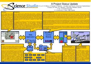
CoffeeTime Web Application Geog 385 Jason Smith 12/15/2011
Purpose • To create a web application to locate Starbucks and Peet’s Coffee shops in the Sacramento Area
Map Service • BaseMap.mxd with scale sensitive layer visibility and labeling of features • Deployed as a Map Service • Layers: CoffeeShops, Major Roads, COS_Streets, Neighborhoods, Parks, Hydro
Geoprocessing Tasks • Create Buffer • Find Drive Thru • Shortest Route
Create Buffer • Created a tool layer in BufferPoint.mxd • Add New Service in ArcGIS Server • Task creates a distance buffer around a point added interactively by user
Find Drive Thru • Created a tool layer in FindDriveThru.mxd • Add New Service in ArcGIS Server • Task selects the coffee shops which have a drive thru window using Select Layer by Attribute
Shortest Route • Created a Route layer using Make Route Layer tool and SacramentoNET data • Created a tool layer in ShortestRoute.mxd • Add New Service in ArcGIS Server • Task finds shortest route between two points interactively selected by user and generates text directions for route
Conclusions • Create Buffer tool worked as expected in web application • Find Drive Thru tool worked in web application, but selection did not use the same legend style as ArcMap tool layer • Shortest Route tool did not work as expected, did not display in web application, but Text Directions did work in web application