Understanding Flood Zone Designations in Lake Charles, LA: A Guide to FIRM Maps
20 likes | 153 Vues
This comprehensive guide delves into the Flood Insurance Rate Map (FIRM) designations for Lake Charles, LA, explaining the significance of various flood zones. It highlights areas outside the 500-year floodplain, the implications of being in a special flood hazard area (Zone AE), and the floodway versus flood fringe zones. Additionally, it interprets important map features such as the community identification number and map revision dates. With this knowledge, residents can better understand their flood risk and navigate the complexities of flood insurance.

Understanding Flood Zone Designations in Lake Charles, LA: A Guide to FIRM Maps
E N D
Presentation Transcript
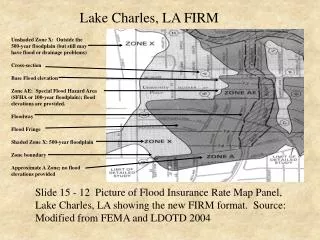
Lake Charles, LA FIRM Unshaded Zone X: Outside the 500-year floodplain (but still may have flood or drainage problems) Cross-section Base Flood elevation Zone AE: Special Flood Hazard Area (SFHA or 100-year floodplain); flood elevations are provided. Floodway Flood Fringe Shaded Zone X: 500-year floodplain Zone boundary Approximate A Zone; no flood elevations provided Slide 15 - 12 Picture of Flood Insurance Rate Map Panel, Lake Charles, LA showing the new FIRM format. Source: Modified from FEMA and LDOTD 2004
Lake Charles, LA FIRM Index and Panel 10 • Community name • Panel Number (on the Map index, all of the • panel numbers are listed) • Six digit community identification number • “220040” followed by the panel number • (“0010”) • Map panel suffix - a letter, • e.g., “B” or “C” • Map effective or map revision date Slide 15 - 13 Title boxes show Community Name, Panel Number, Six-digit Community Identification Number, Map Panel Suffix, and Map Effective or Map Revision Date. Source: FEMA and LDOTD 2004