Estuaries
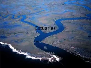
Estuaries. Chapter 12 Where Rivers Meet the Sea. Semi-enclosed areas where fresh water meets and mixes with sea water Among the MOST PRODUCTIVE environments on the Earth Probably the environment MOST effected by human interactions

Estuaries
E N D
Presentation Transcript
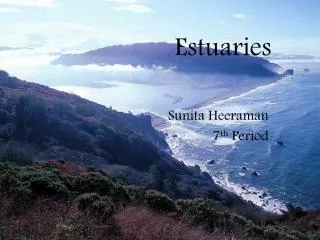
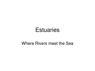
Estuaries Chapter 12 Where Rivers Meet the Sea
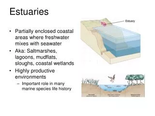
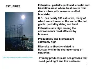
Semi-enclosed areas where fresh water meets and mixes with sea water • Among the MOST PRODUCTIVE environments on the Earth • Probably the environment MOST effected by human interactions • New York, London, Toyko (and Baltimore) developed on wetlands • Areas dredged and filled for development Estuaries
After reading the articles, • What are some challenges facing the Chesapeake Bay? • What are some organisms affected by the Bay’s health? How? • What is being done to improve the health of the bay? What is the progress of these initiatives? What’s going on?
What is being done to improve the health of the bay? What is the progress of these initiatives?
18, 000 years ago • During the last Ice Age, mile-thick glaciers stretched as far south as Pennsylvania, and the Atlantic coastline was about 180 miles farther east than it is today. • Glacial sheets from the most recent Ice Age begin to retreat. The region’s climate begins to warm. Brief History of the Chesapeake Bay
15,000 Years Ago • As the climate continues to warm, a landscape dominated by conifers begins transitioning to a mix of hardwood species, such as oak, maple and hickory. • 11,500 Years Ago • The climate becomes increasingly humid, and the landscape gives way to hardwood forests and coastal wetlands. • Paleo-Indians modify their technology accordingly, replacing Clovis points with spear-throwing devices that could be launched over expansive terrain. Chesapeake Bay History
10, 000 to 7, 000 year ago • Ice sheets continue to melt, flooding the Susquehanna, Potomac, James and York rivers and submerging river valleys under hundreds of feet of water. Sea levels continue to rise as water pours into the Atlantic. • The Chesapeake Bay’s outline begins to form. Ice Age creatures, such as mammoths and giant beavers, are now extinct. Chesapeake Bay History
5, 000 years ago • Temperatures continue to increase. A mixed deciduous forest habitat much like today’s forests dominates the region. • Diverse fish and shellfish populations are abundant in the region’s rivers. • Acorns and other nuts become a key food source. • The first oysters colonize the Bay. History of the Chesapeake Bay
2000 years ago • The Chesapeake Bay’s coastline resembles today’s. • The Bay's waters are dominated by oysters, clams and fish such as bass and shad. • Native American populations continue to develop more sophisticated hunting methods, such as the bow and arrow. Shellfish becomes an important food source Chesapeake Bay History
1000-1500 • Native American agriculture results in more permanent town villages. Native Americans clear land to grow crops such as corn, squash, beans and tobacco. • The Chesapeake Bay region is home to only a few thousand humans (24, 000 people) but many plants and animals, including 200 species of fish, 300 species of birds and 120 species of mammals History of the Chesapeake Bay
1524 - Italian Captain Giovanni da Verrazano is the first recorded European to enter the Chesapeake Bay. • 1561 - While exploring Virginia, Spanish conquistadors capture a young Native American. They name him Don Luis and bring back to Spain, where he receives formal education • 1570 - Don Luis returns to the Chesapeake region as a guide and interpreter with the St. Mary’s Mission, a group of Spanish Jesuits seeking to establish a religious camp. • Don Luis quickly abandons the group and returns to his people. • Months later, he leads a massacre against the St. Mary’s Mission, killing all but one member, a young boy. History of Chesapeake Bay
1607 - The Virginia Company of London, arrives in the Chesapeake Bay. They establish the first permanent English settlement in North America at Jamestown, Virginia. • 1608 - Captain John Smith sets off on his first of two voyages around the Chesapeake Bay. He keeps a journal with detailed descriptions of his surroundings. In the years to follow, he draws an elaborate and remarkably accurate map of the Chesapeake Bay and its rivers. History of Chesapeake Bay
The Bay is about 200 miles long, stretching from Havre de Grace, Maryland, to Virginia Beach, Virginia. • The Bay's width ranges from 4 miles near Aberdeen, Maryland, to30 miles near Cape Charles, Virginia. • The Bay is surprisingly shallow. Its average depth, including all tidal tributaries, is about 21 feet. A person who is 6 feet tall could wade through more than 700,000 acres of the Bay and never get his or her hat wet. • A few deep troughs run along much of the Bay's length. Some of these troughs are as much as 174 feet deep. The troughs are believed to be remnants of the ancient Susquehanna River. • The Bay and its tidal tributaries have 11,684 miles of shoreline – more than the entire U.S. west coast. • The surface area of the Bay and its tidal tributaries is approximately 4,480 square miles. • Two of the United States’ five major North Atlantic ports – Baltimore and Hampton Roads – are on the Bay. Just the Facts…
The entire area of land that drains into a body of water • The Chesapeake Bay’s land-to-water ratio (14:1) is the largest of any coastal water body in the world. Watershed
The Bay receives about half its water volume from the Atlantic Ocean. The rest drains into the Bay from an enormous 64,000-square-mile watershed. • The Chesapeake Bay watershed includes parts of six states – Delaware, Maryland, New York, Pennsylvania, Virginia and West Virginia – and the entire District of Columbia. • The Chesapeake Bay watershed is home to more than 17 million people. About 150,000 new people move into the Bay watershed each year. • There are nearly 18,000 local governments in the Bay watershed, including towns, cities, counties and townships. • About 150 streams, creeks and rivers drain to the Chesapeake Bay watershed. • The Chesapeake Bay holds more than 18 trillion gallons of water. • Collectively, the Chesapeake’s three largest rivers – the Susquehanna, Potomac and James rivers – provide more than 80 percent of the fresh water to the Bay. • Approximately 51 billion gallons of water flow into the Bay each day from its freshwater tributaries. • The Susquehanna River is the Bay’s largest river. It provides nearly 50 percent of the fresh water coming into the Bay – an average of 19 million gallons of water per minute. • More than 100,000 streams, creeks and rivers thread through the Chesapeake Bay watershed. Everyone in the watershed lives within a few miles of one of these tributaries, which are like pipelines from our communities to the Bay. • The Chesapeake Bay watershed contains three distinct geologic regions: the Atlantic coastal plain, the Piedmont plateau and the Appalachian province. • Approximately 7.3 million acres of land in the Bay watershed portions of Maryland, Pennsylvania, Virginia and the District of Columbia are permanently preserved from development. • Supports 348 species of finfish and 173 species of shellfish; • supports more than 3,600 species of plant and animal life, including 2,700 types of plants and more than 16 species of underwater grasses;
Land divided into regions that are similar in topography and geology, which affect • Types of soils • Flora • Fauna • Stream patterns • Climate • Land use. Geologic Provinces
The Appalachian Province lies in the western and northern parts of the watershed. These areas are characterized by mountains and valleys, and they are rich in coal and natural gas. Sandstone, siltstone, shale and limestone form the bedrock. • Most of the water from the Appalachian Province flows into the Bay from the Susquehanna River. • The Appalachian Plateau has many forests and, of all the provinces in the Chesapeake Bay watershed, gets the greatest amount of rainfall each year. Appalachian Province
The Piedmont Plateau ranges from the fall line westward to the Appalachian Mountains. • The Piedmont (literally “foot hills”) is a region of mixed hardwood forests and softwood barren lands bordering on swift running freshwater rivers and streams. Piedmont Plateau
The coastal plain extends westward from the continental shelf to a fall line, the boundary separating the soft sediments of the Coastal Plain from the hard bedrock of the Piedmont. • The edge of the Piedmont/Coastal Plain is marked by a line of waterfalls (the Fall Line) where various rivers move from harder to softer bedrock. • (The waterfalls are most obvious at Great Falls on the Potomac River, on the Rappahannock River at Fredericksburg, and on the James River near downtown • Cities like Baltimore, Maryland; Washington, D.C.; and Richmond, Virginia, were built along the fall line to take advantage of potential water power generated by the falls. These cities became important commerce areas, as colonial ships could not sail past the fall line and had to stop to transfer their cargo to canals or overland shipping. Coastal Plain
Flat landscape borders both sides of the Chesapeake Bay and encompasses the entire Eastern Shore. Elevations here range from a low of 0 feet at sea level to a high of 400 feet at the border with the Piedmont. • Water passing through this loosely compacted mixture dissolves many of the minerals. The most soluble elements are iron, calcium and magnesium. Coastal Plain
Timeline Resources - http://www.chesapeakebay.net/history • Geologic Provinces • http://www.doe.virginia.gov/instruction/science/elementary/lessons_bay/about_watershed/geology_watershed.shtml • http://www.chesapeakebay.net/discover/bayecosystem/baygeology • Maps – • http://www.cbf.org/about-the-bay/maps • http://www.virginiaplaces.org/regions/fallshape.html • www.chesapeakebay.net/content/publications/cbp_19653.pdf
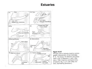
Chapter 12 Estuaries: Where Rivers Meet the Sea
Salty seawater (35 ppt) entering is more dense an flows along the bottom as it enters the estuary • Fresher, less dense water from the rivers flow out on the surface • This creates a salt wedge • Salt wedge moves back and forth with tides • Organisms that stay in one place face large variations of salinity throughout the day Salinity
Rainfall/snowfall – • Salinity of estuary decreases with heavy rains/snowmelt • Salinity increases in drought conditions • Seasonal variations in salinity occur (high salinity in summer, lower salinity in spring) Physical Characteristics
Long and narrow estuaries have stronger tidal currents • The Coriolis effect causes freshwater flowing to the sea to be deflected to the right • In the Chesapeake Bay, salinity is higher on the eastern side of the Bay than on the western side Physical Characteristics
Rivers carry large amounts of sediment and other materials into estuaries • Sand and other coarse materials settle out in upper reaches where the river flow slows • Finer, muddy particles are carried further down the estuary where current slows even more Substrate
Because of lack of primary producers in substrate, detritus is the main food source • Coarse sands/gravels dry out quickly and therefore contain little organic matter/living things • Clay/muddy substrates does not allow water through easily bringing little oxygen below the surface • In anoxic conditions, bacteria use anaerobic respiration to breakdown organic matter • Break down sulfates to produce hydrogen sulfide (H2S) – a noxious gas Substrate
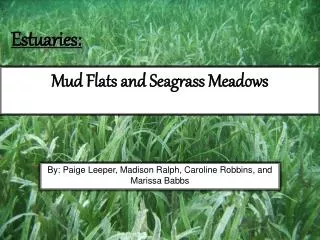
Tidal regions bordered by grassy areas; partially flooded at high tides • Collect sediment from rivers; roots of plants stabilize sediment on bottom • Cordgrasses most common at point where water meets land – soil is oxygen rich and less salty; have underground stems with roots and leaves shooting from stem; excrete excess salt from salt glands in leaves Salt Marshes
Important for: • Plants slow down tidal flow • Increase sediment trapped in roots • Decrease effects of wave action • Primary production of ecosystem • Decomposition by bacteria • Habitat for burrowing animals, invertebrates, insects, and fish • Nitrogen fixation Salt Marshes
Nutrients brought in by tides and rivers, nitrogen fixating bacteria, and decomposition are used by plants, algae, and bacteria (all primary producers) • High primary production supports large amounts of biomass • Supplies large amounts of detritus • Detritus sinks to bottom and provides food to organisms • Excessive detritus is washed into ocean and provides nutrients to marine environments Feeding Interactions