Download
1 / 41
410 likes | 558 Vues
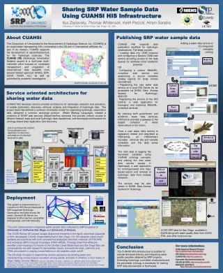
Introduction to CUAHSI Water Web Services and Texas HIS. David R. Maidment The University of Texas at Austin. HIS Team and Collaborators. University of Texas at Austin – David Maidment, Tim Whiteaker San Diego Supercomputer Center – Ilya Zaslavsky, David Valentine, Tom Whitenack

E N D
Introduction to CUAHSI Water Web Services and Texas HIS David R. Maidment The University of Texas at Austin
HIS Team and Collaborators • University of Texas at Austin – David Maidment, Tim Whiteaker • San Diego Supercomputer Center – Ilya Zaslavsky, David Valentine, Tom Whitenack • Utah State University – David Tarboton, Jeff Horsburgh, Kim Schreuders, Justin Berger • Drexel University – Michael Piasecki, Yoori Choi • University of South Carolina – Jon Goodall, Tony Castronova • Idaho State University – Dan Ames, Ted Dunsford, Teva Veluppillai • CUAHSI Program Office – Rick Hooper, David Kirschtel, Conrad Matiuk • WATERS Network – Testbed Data Managers • HIS Standing Committee • USGS – Bob Hirsch, David Briar, Scott McFarlane • NCDC – Rich Baldwin • ESRI – Dean Djokic, Christine Eggers, and many others
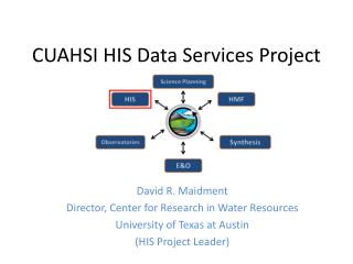
CUAHSI Water Web Services and Texas HIS • CUAHSI Hydrologic Information System • CUAHSI Water Data Services • Texas Water Data Services
CUAHSI Water Web Services and Texas HIS • CUAHSI Hydrologic Information System • CUAHSI Water Data Services • Texas Water Data Services
Consortium of Universities for the Advancement of Hydrologic Science, Inc (CUAHSI) 118 Universities in North America (and 3 in Europe) NSF supports building a Hydrologic Information System (HIS)
Synthesis and communication of the nation’s water data http://his.cuahsi.org Federal Water Data Academic Water Data State and Local Water Data To make a complete picture of water data, we need to be able to add state and local data to national and academic data sources. Regional Water Data Systems
Water Observations Data Water quantity Soil water Rainfall Water quality Groundwater Meteorology
Services-Oriented Architecture A services‐oriented architecture is a concept that applies to large, distributed information systems that have many owners, are complex and heterogeneous, and have considerable legacies from the way their various components have developed in the past (Josuttis, 2007).
Web pages Web services We are at a tipping point… Internet Internet Internet WaterML People interact with a remote information server People interact with a network of Information services
HTML as a Web Language HyperText Markup Language Text and Pictures in Web Browser <head> <meta http-equiv="content-type" content="text/html; charset=utf-8" /> <title>Vermont EPSCoR</title> <link rel="stylesheet" href="epscor.css" type="text/css" media="all" /> <!-- <script type='text/javascript' language='javascript‘ src='Presets.inc.php'>--> </head>
Point Water Observations Time Series A point location in space A series of values in time
WaterML as a Web Language Discharge of the San Marcos River at Luling, TX June 28 - July 18, 2002 Streamflow data in WaterML language
CUAHSI Water Web Services and Texas HIS • CUAHSI Hydrologic Information System • CUAHSI Water Data Services • Texas Water Data Services
Base Station Computer(s) Telemetry Network Sensors CUAHSI Water Data Services System Discovery Analysis Access Query, Visualize, and Edit data using ODM Tools HydroSeek GIS Matlab Splus R IDL HIS Desktop Java C++ VB ODM Database Service Registry HydroTagger WaterML Streaming Data Loader GetSites GetSiteInfo GetVariableInfo GetValues Excel, text HIS Central Harvester USGS NWIS Water Metadata Catalog WaterOneFlow Web Service ODM Data Loader EPA STORET NCDC Others
Point Observations Information Model Information is transmitted through the internet in WaterML as web services Utah State Univ Data Source Little Bear River Network GetSites Little Bear River at Mendon Rd Sites GetSiteInfo GetVariableInfo Dissolved Oxygen Variables GetValues 9.78 mg/L, 1 October 2007, 5PM Values {Value, Time, Metadata} • A data source operates an observation network • A network is a set of observation sites • A site is a point location where one or more variables are measured • A variable is a property describing the flow or quality of water • A value is an observation of a variable at a particular time • A metadata quantity provides additional information about the value
Data Values – indexed by “What-where-when” Time, T Data Values Table t “When” vi (s,t) “Where” s Space, S Vi “What” Variables, V
Data Series – Metadata description Time End Date Time, t2 There are C measurements of Variable Vi at Site Sj from time t1 to time t2 Count, C Begin Date Time, t1 Site, Sj Space Variable, Vi Variables
Series Catalog Time Sj End Date Time, t2 Vi Count, C Begin Date Time, t1 Site, Sj Space Variable, Vi Variables t1 t2 C
CUAHSI Observations Data Model Values Series http://his.cuahsi.org/odmdatabases.html
HIS Servers at Universities in the WATERS Network HIS Central at San Diego Supercomputer Center
CUAHSI Water Data Services 35 services 15,000 variables 1.75 million sites 8.33 million series 342 million data
CUAHSI Water Web Services and Texas HIS • CUAHSI Hydrologic Information System • CUAHSI Water Data Services • Texas Water Data Services
Texas Water Data Services 10 services 7,010 variables 15,870 sites 645,566 series 23,272,357records
Publishing an ODM Water Data Service TPWD Coastal Fisheries Raw Data TWDB Coastline Raw Data TIFP Lower Sabine Ingest Data From Different Sources Data Upload Transform Data into Uniform Format WaterML Load Newly Formatted Data into ODM Tables in MS SQL/Server Observations Data Model (ODM) TPWD ODM TWDB ODM TIFP ODM Wrap ODM with WaterML Web Services for Online Publication
Publishing a Hybrid Water Data Service TCOON Metadata are Transferred from XML to the ODM WaterML TCOON DataValues TCOON METADATA ODM Web Services can both Query the ODM for Metadata and use a Web Scraper for Data Values TCOON Water Data Service Get Values from: Metadata From: ODM Database in Austin TCOON Web Site in Corpus Christi GetSites GetSiteInfo GetVariableInfo http://his.crwr.utexas.edu/tcoonts/tcoon.asmx?WSDL Calling the WSDL Returns Metadata and Data Values as if from the same Database
Web Services in Space and Time • Water Markup Language (WaterML) is a schema for encoding water observations time series data and metadata; • Geographic Markup Language (GML) encodes spatial data about sets of geographic features; • so that you can transmit water data in space and time
WFS and WaterML Observations Metadata in Space in GML as a Web Feature Service Observations Data in Timein WaterML
A Theme Layer Synthesis over all data sources of observations of a particular variable e.g. Salinity
Texas Salinity Theme 7900 series 347,000 data 7900 series TPWD 3400 TCEQ 3350 TWDB 150
Copano and Aransas Bay Salinity Number of Data 0 – 50 50 – 150 150 – 400 400 – 1000 1000 – 3000 Copano Bay Aransas Bay
Texas Daily Streamflow Theme USGS Data 1138 sites (400 active)
Austin – Travis Lakes Streamflow Years of Data 0 – 10 10 – 20 20 – 40 40 – 60 60 – 110
Texas Water Temperature Theme 22,700 series 966,000 data
Austin – Travis Lakes Water Temperature Number of Data 0 – 50 50 – 150 150 – 400 400 – 1000 1000 – 5000
Texas Natural Resources Information System Data Viewer – Observation Sites
Conclusions • We have built a successful and functioning services-oriented architecture for water observations data in the United States • WaterML is critical as the common water data language • A lot of water information is best accessed and indexed at the state and regional level • CUAHSI HIS would like to work with academic partners to build state and regional HIS
HIS Website – his.cuahsi.org Download tools, research publications, contribute to the effort – it’s all here