LPVEx Workshop Agenda: Science Overview, Operations, and Data Analysis Strategies
Join us for an insightful workshop focused on the LPVEx (Light Precipitation Validation Experiment), featuring sessions on radar scanning strategies, aircraft operations, personnel schedules, and data management. Learn about the capabilities of various radars and microwave instruments in detecting light precipitation and the complexities of data retrieval in challenging environments. The agenda includes breaks for collaboration and an overview of post-experiment activities. This workshop aims to enhance our understanding of precipitation characteristics and improve observational strategies.

LPVEx Workshop Agenda: Science Overview, Operations, and Data Analysis Strategies
E N D
Presentation Transcript
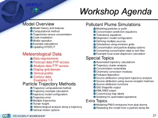
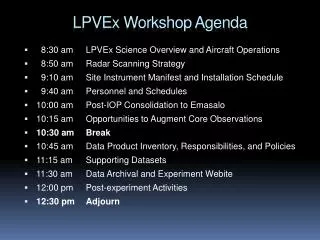
LPVEx Workshop Agenda • 8:30 am LPVEx Science Overview and Aircraft Operations • 8:50 am Radar Scanning Strategy • 9:10 am Site Instrument Manifest and Installation Schedule • 9:40 am Personnel and Schedules • 10:00 am Post-IOP Consolidation to Emasalo • 10:15 am Opportunities to Augment Core Observations • 10:30 am Break • 10:45 am Data Product Inventory, Responsibilities, and Policies • 11:15 am Supporting Datasets • 11:30 am Data Archival and Experiment Webite • 12:00 pm Post-experiment Activities • 12:30 pm Adjourn
Science Goals • Characterize the relative abilities of space-based W, Ku-, and Ka-band radars and microwave imagers and sounders to detect light. • What are the detection limits of each instrument? • Can rainfall probabilities be assigned to Z and TB signatures? • Evaluate retrievals of rainfall intensity in shallow freezing level environments. • How does the ratio of cloud-rain impact PIA and PMW TBs? • How does the vertical structure of precipitation impact emission/attenuation-based algorithms? • What are the impacts of other algorithm assumptions including DSD and melting layer properties on rainrate estimates? • How do well are FOV-dependent factors such as beamfilling and multiple-scattering represented? • Determine the properties of the local environment that influence the characteristics of precipitation in this region.
Set-up • Green = FMI Wx Stn • = Enhanced Obs. • = Vaisala WxTs (inc. rain) • Gray circles = 20 km radar range rings = Spiral = Stacked flight tracks Kerava NW Kerava NE Järvenpää Turku Maximum Extent of Flight Operations Kerava SW Kerava Emasalo Region of Likely Flight Operations Kumpula Ferry Kumpula SE Harmaja Kalbadaglund Gulf Stack Kumpula SW Ferry RV Aranda Ops. Spiral S1
Aircraft Operations • Wyoming King Air • W-band cloud radar • Water content: DMT, Gerber, Nevzorov • Microphysics: 2D-P, CIP, CDP (FSSP/2D-C) • Aerosol: PCASP-100X • Environment: RH, T, altitude, wind speed • Departing Wyoming ~Sept. 1 (5 days in transit) • 3-5 days installation + 4 hours of test flights (Sept. 8-14) • Research flights: • Begin Sept. 15, 2010 • Based in Turku – 30 minute transit to Helsinki • 50 total research flight hours budgeted (~13-14 flights) • End no later than Oct. 20, 2010
Data Z • Radar quicklooks will be ready within 24 hours of all research flights. • First cut versions of many probe datasets (eg. DSDs, water contents) will also be turned around in 24 hours and stored along with radar data in a netCDF file for each flight segment. DSD/PSD RH and LWP T and z
Fight Tracks: Leg FIR • Leg FIR0-FIR15 • Plan to fly this path at different altitudes: • FIR0 at 500’ MSL • FIR1 at 1000’ MSL • FIR2 at 2000’ MSL • Similar up to FIR15 at FL150 • The FIR Leg will be repeated five times. Either: FIR0, FIR3, FIR5, FIR7, FIR15 • *OR* FIR1, FIR4, FIR9, FIR15, FIR4.
FIR Legs Kerava Radar FIR Leg: FIR0-FIR15 Pt. 1 Kumpula Radar Pt. 2 FIR Leg: FIR0-FIR15 Pt. 4 Pt. 3
RHI Tracks • Along axis of ground research radars • 4 legs at different altitudes that depending on weather conditions. The lowest altitude will be 1000 ft. above highest terrain/obstacle as dictated by controlling authority. • ~60 Kilometer Tracks: • Jarvenpaa, Mansala, and Porvoo (with KER RHIs) • ~30 – 40 Kilometer Tracks: • Kumpula and Emasalo (with KUM RHIs)
RHI Tracks Pt. 13 Track: Mansala 2-15 Pt. 15 Track: Jarvenpaa 2-15 Pt. 12 Pt. 14 Pt. 11 Pt. 10 Track: Kumpula 0-15 Track: Porvoo 2-15 Kerava Radar Pt. 6 Track: Kumpula 0-15 Track: Emasalo 0-15 Kumpula Radar Pt. 8 Pt. 1 Pt. 9 Pt. 5 Pt. 6 Pt: 4 Pt: 3
Spirals • Spiral descent: • 500 fpm descent rate • 1 minute legs • standard rate turns • from FL 150 to 1000’ AGL (500’ over water) • Option: can do small race-tracks or continuous descents
Spirals over Ground Sites Pt. 16 Spiral: S5 Spiral: S3 Kerava Radar Pt. 8b Pt. 1 Kumpula Radar Spiral: S2 Spiral: S1 Pt. 2 Pt. 7 Spiral: S4 Pt. 4 Pt. 3
Daily Briefing Schedule • 5:00 pm Weather briefing/initial decision regarding operations the following day • 7:30 am Updated weather/Baltic radar analysis for definition of potential flight tracks • 8:00 am Report to ATC with planned tracks and approx. take-off time • TO-1 hour Final check of radar; go/no-go decision • TO-0.5 hour Pre-flight briefing with aircraft team (Turku airport) • L+0.5 hour Post-flight briefing with aircraft team (Turku airport) • L+1 hour Flight/ground-operations tag-up (small group) • L+6 hours Daily operations summary posted on website (weather summary, instrument notes, flight specifics, data quicklooks, etc.) • Three bases of operation: Kumpula campus, Turku airport hangar, and office at Hotel Centro (Turku)
Coordination • In-flight communications – 2-way radio (source TBD) • Initially restricted to pre-defined flight tracks but may have more flexibility as experiment progresses • Aircraft Tracking: REVEAL box will transmit lat/lon and altitude that can be ingested and plotted with radar software in real-time • Ingest being tested now • To keep briefings running smoothly, group discussions should be held in each location independently and relayed to other group via a small number of group leads via Skype/web-meeting