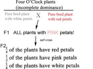
Black
Black. Gold. Gold. The Triangle Prospect. Following is a map of 10 seismic lines. The lines are 1 mile apart from each other and each line records a seismic stack trace per mile. In real life, traces are recorded every 50 feet or so.


Black
E N D
Presentation Transcript
Black Gold Gold The Triangle Prospect
Following is a map of 10 seismic lines. The lines are 1 mile apart from each other and each line records a seismic stack trace per mile. In real life, traces are recorded every 50 feet or so. The slides that follow are the plots of the stack traces. Time in ms is the left scale, distance in miles is the bottom scale. Each line records six seismic reflectors. Five of these reflectors are flat (constant depths). The sixth reflector, the target reflector is not flat. Use the previously computed constant depth of reflector 5, the reflection times of reflector 6 (from the line plots or associated spreadsheet), and the previously computed interval velocity between reflector 5 and 6 (the target reflector) to compute the depth to the target reflector at all the points on the map. You will have 19 values for each of nine lines for a total of 20x9=190 data points. You may use the line plots for your computations by measuring the time difference between reflectors 5 and 6, or you may use the associated spreadsheet (much easier). The answer may be a map with depth values (good), or a spread sheet (better). Note that subsurface elevation is measured relative to the surface; and is, therefore a negative number. Note the polarity inversion for reflector 3. Your task is to compute the elevation value below sea level for reflector six at each circle location ie (x,y,z) where “mile”=x, “line”=y, and elevation=z.
Map of 9 seismic lines compute depth values at all these data points (red circles 9 Line Number, 1 mile apart 6 Fault 3 Miles 0 3 6 9 12 15 18
Line 0 Miles
line 1 Miles
line 2 Miles
line 3 Fault Miles
line 4 Fault Miles
line 5 Fault Miles
line 6 line 6 Fault Miles
line 7 Fault Miles
line 8 Miles
line 9 Miles