Download
1 / 11
110 likes | 220 Vues
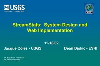
StreamStats: System Design and Web Implementation. 12/18/02 Jacque Coles - USGS Dean Djokic - ESRI. System Design – Core Concepts (1). Map Server (ArcIMS). Client (IE 5.5). Data Server (ArcSDE). Web Server (IIS, ASP). Client (IE 5.5). Client (IE 5.5).

E N D
StreamStats: System Design and Web Implementation 12/18/02 Jacque Coles - USGS Dean Djokic - ESRI
System Design – Core Concepts (1) Map Server (ArcIMS) Client (IE 5.5) Data Server (ArcSDE) Web Server (IIS, ASP) Client (IE 5.5) Client (IE 5.5) Application Server (ArcMap, NFF) Database (SQL Server)
System Design – Core Concepts (2) • Web, Application, Map, and Data Servers are separate machines (but could be combined depending on the load and performance requirements). • Current design is based on Windows platform. • Scalability for Application Servers is accomplished by adding more physical servers (computers) with ArcGIS on them.
MS Processing Roles (1) DS WS AS • Web Client requests map activity (zoom in/out, delineation at a point, etc.) • The request is sent to the Web Server. • If the request is one for standard map operations, it is forwarded to the Map Server • If the request is for watershed delineation/NFF computations, it is forwarded to the Application Server Web Server maintains connection between the client and the Map and Application Servers.
MS Processing Roles (2) DS WS AS • Application Server performs watershed delineation and characteristics extraction (ArcGIS) and flood frequency computations (NFF). The results are stored in the database through the Data Server (ArcSDE). • Communication between the Web and Application Servers is through a dedicated socket port.
MS Processing Roles (3) DS WS AS • Map Server (ArcIMS) manages standard internet-based mapping activities (zooming, panning, turning layers on and off, etc.). Data for map-based operations reside in the database accessible through the Data Server (ArcSDE). • Application and Map Servers do not communicate directly, but they do share the same database. “Communication” between the two is via Web Server.
MS Processing Roles (4) DS WS AS • Data Server (ArcSDE) stores the data for the Application Server and serves the data to the Map Server.
USGS Streamstats Hardware • Web Server • Dell PowerEdge 1650 Pentium III, 1.26GHz Single Processor • 512MB SDRAM • Two 36GB SCSI 160 Drives • RAID 1 • Application Server • Dell PowerEdge 2500 Pentium III, 1GHz Dual Processors • 1GB SDRAM • 6x36GB SCSI U3/160 Hard Drives • Tape Backup • RAID 5
USGS Streamstats Configuration IIS, ASP ArcIMS ArcMap ArcSDE SQL Server Data, NFF Web Server Request to ArcMap App. Server Response from ArcMap Request to IMS Response from IMS Internet
Communication Between Server Applications • ASP routes requests to either IMS or Application server • IMS handles map related requests – ZI,ZO,Pan • Application server handles application specific requests • Application server has an open port for ASP to communicate with ArcMap • Deliniation – polygon returned to IMS for Web viewer • GetParameters – parameters related to topographic and hydrologic data returned to IMS for Web viewer
Communication Between Server Applications (2) • Programming was done by ESRI Denver and Redlands • ASP, VB, ArcIMS and ArcObjects on server side • JavaScript and DHTML on the client side • Salmon and Clearwater basins (25,000 sq. mi. – 18 cataloging units) to be implemented by the end of January on the Idaho servers for restricted use