Download
1 / 11
120 likes | 252 Vues
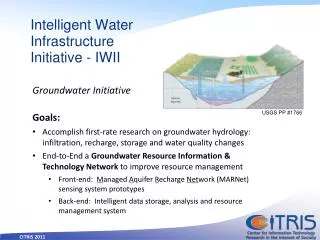
Intelligent Water Infrastructure Initiative - IWII. USGS PP #1766. Goals: Accomplish first-rate research on groundwater hydrology: infiltration, recharge, storage and water quality changes End-to-End a Groundwater Resource Information & Technology Network to improve resource management

E N D
Intelligent Water Infrastructure Initiative - IWII USGS PP #1766 • Goals: • Accomplish first-rate research on groundwater hydrology: infiltration, recharge, storage and water quality changes • End-to-End a Groundwater Resource Information & Technology Network to improve resource management • Front-end: Managed Aquifer Recharge Network (MARNet) sensing system prototypes • Back-end: Intelligent data storage, analysis and resource management system Groundwater Initiative
Rationale • Population and climate change projections point to changing snow pack (key annual storage) • Increasing surface impoundments is costly, impractical; good sites are taken, political challenges, env. impacts • California groundwater is consistently over-drafted, especially in dry years, yet provides the best option for new supply • Our understanding of when and where recharge occurs is vague Data from DWR’s California Water Plan Update (2009)
Scientific Challenges • Connection between surface water infiltration and groundwater recharge is not well understood • Large time scales for groundwater basins (hard to observe) • Heterogeneity of subsurface challenging to characterize • Simulation models difficult to validate and maintain • Recharge and GW storage require local assessment • Each basin is different, local collaboration needed • Connections between SW-GW, water supply and quality • California lacks statewide statutory structure • As enshrined in state constitution, groundwater is mostly unmanaged • Individual basins have to develop customized approaches based on local hydrology, climate, costs, politics
Technical Challenge: Cyber-infrastructure • Sensor systems are being demonstrated in isolated pilot studies, and a physical MARNet monitoring network is feasible • Creating a transferrable system will require common: • Sensors and deployment methods • Data and metadata standards • First-order and near-real time analyses (e.g. raw data flux) • Simulation modeling approaches • Integrating software environment • Data archiving, cleaning, gap-filling, resampling • Model calibration, validation, forecasting (including automation) • Systems analysis: optimal water resource management tools
MARNet Mission • Technology for rapid, accurate assessment of groundwater resource changes • In/outflow, ET, infiltration, recharge, groundwater migration • Intensively instrumented model sites distributed throughout California (and other water stressed regions of the world) • Automated data visualization, analysis • Render groundwater resource management easy and transparent • Replicate this model locally and integrate regionally to provide an exemplary resource managemetn network • Varying geography, hydrogeology, land use, etc. • Explore natural and engineered infiltration-recharge
Sensor system conceptual diagram • A multi-scale design of local mesh network(s) and cellular/satellite gateway(s) • High granularity pressure/depth, flow, temperature, salinity, soil moisture, and meteorological parameters • Low granularity water quality sensors, and supporting sampling program adapted from
Potential partners, pilots and funding strategies • Establish management partners first based on established relationships, desire for collaboration • Not all districts/municipalities want outside help – focus on a few type locations where we can make rapid progress, demonstrate success • Identify regional partners so that UC personnel can be on site a lot – required to establish commitment, gain trust, design and maintain proper networks, work with locals on adjusting operations, take advantage of opportunities • Work with a variety of management units, from large systems that are part of statewide transfers (e.g., KWB) to smaller basins that are “off the grid” and managing their resources independently (e.g., PVWMA).
Next Steps • Achieve state support of the idea that an information infrastructure is a critical element of the State Water Plan with respect to groundwater monitoring • Build a public-private consortium to fund the development of a prototype system by 2015 • Build political support for continued funding of water supply intelligent infrastructure investment by California • Establish partnerships to begin discussion and collaboration, move forward where/when possible
Current research assets • Four prototype data collection systems: • Sierra Nevada Snowpack project (Southern Sierra Critical Zone Observatory, American River Observatory) led by Profs. Roger Bales, UCM, and Steven Glaser, UCB • Coastal Aquifer Recharge projects led by Prof Andrew Fisher, UCSC • Delta Drifter project led by Prof. Alex Bayen, UCB • Delta Levee Safety project led by Prof. Ray Seed, UCB
Real-time monitoring of Managed Aquifer Recharge Water is diverted from nearby wetland, infiltrates into underlying aquifer • The Solution: • Heat is used as a tracer to map out timing and locations of infiltration • Water quality assessed in percolation pond and monitoring wells • Data telemetered back to base station in real time, posted at web site for rapid assessment and analysis of infiltration • The Problem: GW recharge is highly variable in space and time • The Goal: Determine patterns of recharge in real time to assist with operations of MAR systems.
IWII Groundwater Team Steven Glaser, Faculty Director, Berkeley Andrew Fisher, Santa Cruz Graham Fogg, Davis Tom Harmon, Merced


![eSafety Intelligent Infrastructure Working Group (IIWG) ]](https://cdn1.slideserve.com/3491244/esafety-intelligent-infrastructure-working-group-iiwg-dt.jpg)