John A. Knaff and Mark DeMaria
10 likes | 105 Vues
A New Tropical Cyclone Formation Product: Operational Implementation for the Atlantic and Eastern Pacific in 2006 and Extension to the Western N. Pacific in 2007. John A. Knaff and Mark DeMaria NOAA - NESDIS - Office of Research and Applications, Fort Collins, CO. Andrea Schumacher

John A. Knaff and Mark DeMaria
E N D
Presentation Transcript
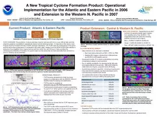
A New Tropical Cyclone Formation Product: Operational Implementation for the Atlantic and Eastern Pacific in 2006 and Extension to the Western N. Pacific in 2007 John A. Knaff and Mark DeMaria NOAA - NESDIS - Office of Research and Applications, Fort Collins, CO Andrea Schumacher CIRA – Colorado State University, Fort Collins, CO Antonio Irving and Nancy Merckle, NOAA - NESDIS - Office of Satellite Data Processing and Distribution, Camp Springs, MD Current Product: Atlantic & Eastern Pacific Product Extension: Central & Western N. Pacific MTSAT GOES-W GOES-E Schematic of Tropical Cyclone Formation Probability (TCFP) Product Algorithm TCFP OVERVIEW: The prediction of where and when tropical cyclones will form is a very difficult task and little objective guidance is available to operational tropical cyclone warning centers. In response to this need, a new Tropical Cyclone Formation Product (TCFP) has been developed. The TCFP uses the vertical shear of the wind and the sea surface temperature in combination with water vapor imagery from the NOAA GOES-East satellite to determine the probability that a tropical cyclone will form within the next 24 hours. It also provides the climatological probability of formation for a given region so that areas that are more favorable than normal for a storm to develop can be identified. NEW DATA SOURCES : Expanding the product involves incorporating water vapor imagery from satellites other than GOES-E. The expanded product will utilize the following satellite sources for each region: • Blue = GOES-E (GOES-8, GOES-12) • Green = GOES-W (GOES-10,GOES-11) • Red = MTSAT (GMS-05,GOES-9, MTSAT-1R) VERIFICATION: • Brier skill score shows that the TCFP improves upon pure climatology • The TCFP is also skillful using the ROC score • Expected yearly number of storms from the TCFP for 1995-2003 ( = P(x,y,t)dxdydt) compare well with the observed yearly number of storms OPERATIONAL PRODUCT : • TCFP became operational for 2006 hurricane season (in collaboration with the NESDIS Office of Satellite Data Processing and Distribution). • TCFP product is available at www.ssd.noaa.gov/PS/TROP/genesis.html. • Predicted and climatological formation probabilities for each 5°x 5° lat/lon grid box are updated every 6h • Cumulative probabilities and average predictor values calculated over 8 subdomains (left) are displayed as time series as part of product FUTURE PLANS: • Expanded TCFP product will be evaluated after the 2007 experimental period • Given positive verification & feedback, operational transition planned for summer 2008 • Looking to develop similar products for the Indian Ocean and Southern Hemisphere (global product) ALGORITHM DEVELOPMENT • Data collection & QC has been completed • Best track data collected from NHC, CPHC & JTWC • Satellite WV imagery collected from CIRA archives and NOAA CLASS satellite archive • Developed monthly TC formation probabilities & monthly climatological values for each predictor • Due to satellite availability, the developmental data sets encompass different time periods: 1995-2005 (Atlantic), 1998-2005 (E/C Pacific), and 2000-2005 (W Pacific) • A preliminary prediction algorithm, including screening and linear discriminant analysis, has been developed and is currently being evaluated and refined • An experimental version of the extended product is expected to be running at CIRA by late spring 2007 Above: Extension product domains based on optimal satellite coverage Above: TCFP product genesis probabilities for 8/21/06 6Z (left), 12Z (center), and 18Z (right). EP07 (Ileana) and AT05 (Debby) both formed during this time period in regions of locally maximized probability. Tropical Atantic Subdomain (2006) Above: Monthly climatological probabilities of TC formation derived from Best Track data. Probabilities were computed over 5°x5° lat/lon grid boxes and then smoothed using a simple 2D filter. Left: Table of predictors that are being considered for the TCFP extension product. Those that were used in the original product are indicated by SCR (used in screening data pts) and LDA (used in linear discriminant analysis). Above: TCFP Subdomains (top) and 2006 time series of cumulative predicted probability (upper left) and subdomain averaged TCFP predictors for the Tropical Atlantic subdomain. The black lines indicate climatological values.