Download
1 / 20
200 likes | 308 Vues
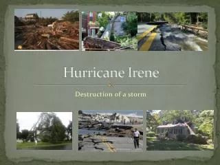
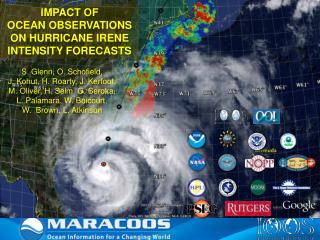
This presentation from the Northeast Regional Operations Workshop (2011) discusses the application of a high-resolution weather model (WRF-ARW) and an impact model developed for Con Edison, New York. The weather model forecasts temperature, wind, and precipitation with a 2 km resolution and provides real-time alerts. The impact model quantifies the number of power outages per substation during Hurricane Irene, which produced sustained winds of 20-50 mph and heavy rainfall. Results reveal the model's effectiveness and challenges in forecasting and nowcasting weather impacts.

E N D
Utilization of a High Resolution Weather and Impact Model to Predict Hurricane Irene • Northeast Regional Operations Workshop 2011 • Albany, NY • Brandon Hertell Lloyd Treinish, Anthony Priano, Hongfei Li, James Cipriani IBM – Thomas J. Watson Research Center
OverviewCon Edison, Inc. Service Territory Con Edison Co. of New York • 3.2 million electric customers • 1.0 million gas customers • 1,800 steam customers • 709 MW of regulated generation Orange and Rockland • 300,000 electric customers • 127,000 gas customers 2
OverviewWeather Model • Utilize WRF-ARW • 2km resolution forecast • Assimilate additional weather data • 24hr/84hr forecast • 2x daily (0z,12z) • Temp, wind, wet bulb, precip • Content available via web browser • Email alert system 18 km 2 km 6 km Model Domain
OverviewImpact Model • Westchester County overhead electric • Post-Process of weather model • Output # of jobs per substation • Quantifies uncertainty • Email alert system • Predictive & Nowcast “mode” Westchester Substation Map
OverviewImpact Model Deep Thunder Weather Model Forecast Historical Weather Data Real Time Observations Calibrated Weather Model Gust Calculation Impact Model Historical Damage Data Model Training Model Training NowCast Predictive Predictive vs. Nowcast Model Design
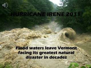
OverviewTropical Storm Irene • Land fall over NYC as a Tropical Storm • Long duration by hurricane standards (18+ hours) • Sustained winds 20-50mph • Wind gusts 40-70mph • Tornado in Queens • Rainfall 5-10” (12” north NYC) • 187,800 customers affected
Results Predicted jobs vs. actual jobs Sunday 28th Saturday 27th Friday 26th 12z 0z 12z 0z Actual Nowcast Predictive Predictive
ResultsFriday – 0z Sustained Wind Max. Daily Gust MPH
ResultsFriday – 0z Number of Jobs Probability
ResultsFriday – 12z Sustained Wind Max. Daily Gust MPH
ResultsFriday – 12z Number of Jobs Probability
ResultsSaturday – 0z Sustained Wind Max. Daily Gust MPH
ResultsSaturday – 0z Number of Jobs Probability
ResultsNowcast Number of Jobs Probability • Nowcast used to check model assumptions • In this case may not be a good check on model accuracy • Dependant on good actual wind data inputs
ResultsObservations AWS wind seem low 00hrs 29th 00hrs 28th
ResultsObservations Gusts more reasonable 00hrs 29th 00hrs 28th
Summary • Impact forecast was close to actual • Forecasts can have large variances • Few large scale events in database • Observational data quality check • Study other cases to check wind accuracy
Questions? Brandon Hertell Meteorologist ConEdison Emergency Management hertellb@coned.com 212-460-3129