Koordinationsschema GIS Elbe
10 likes | 135 Vues
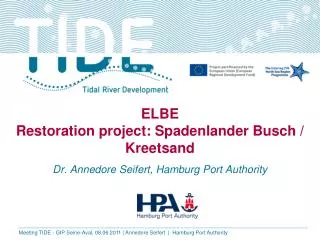
GIS 02/1/2 rev. Koordinationsschema GIS Elbe. ICG WFD Internationale Koordinierungsgruppe „EU - Wasserrahmenrichtlinie im Einzugsgebiet der ELBE“. Arbeitsgruppe WFD „Umsetzung der EU - Wasserrahmenrichtlinie im Einzugsgebiet der ELBE“ Leitung: MR Rolf-Dieter Dörr.

Koordinationsschema GIS Elbe
E N D
Presentation Transcript
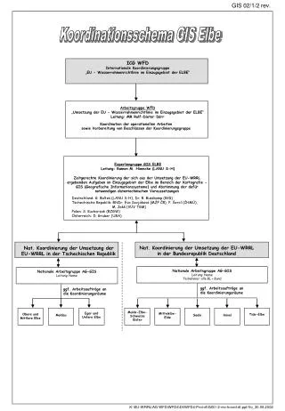
GIS 02/1/2 rev. Koordinationsschema GIS Elbe ICG WFD Internationale Koordinierungsgruppe „EU - Wasserrahmenrichtlinie im Einzugsgebiet der ELBE“ Arbeitsgruppe WFD „Umsetzung der EU - Wasserrahmenrichtlinie im Einzugsgebiet der ELBE“ Leitung: MR Rolf-Dieter Dörr Koordination der operationellen Arbeiten sowie Vorbereitung von Beschlüssen der Koordinierungsgruppe Expertengruppe GIS ELBE Leitung: Ramon M. Hiemcke (LANU S-H) Zeitgerechte Koordinierung der sich aus der Umsetzungder EU-WRRL ergebenden Aufgaben im Einzugsgebiet der Elbeim Bereich der Kartografie - GIS (Geografische Informationssysteme)und Abstimmung der dafür notwendigen datentechnischen Voraussetzungen Deutschland: G. Baltes (LANU S-H), Dr. R. Busskamp (BfG) Tschechische Republik: RNDr. Eva Sovjáková (MŽP ČR), P. Šercl (ČHMÚ), M. Jakš (VÚV TGM) Polen: S. Kucharzak (RZGW) Österreich: D. Gruber (UBA) Nat. Koordinierung der Umsetzung der EU-WRRL in der Bundesrepublik Deutschland Nat. Koordinierung der Umsetzung der EU-WRRL in der Tschechischen Republik Nationale Arbeitsgruppe AG-GIS Leitung: Name Teilnehmer: alle BL + Bund Nationale Arbeitsgruppe AG-GIS Leitung: Name ggf. Arbeitsaufträge an die Koordinierungsräume ggf. Arbeitsaufträge an die Koordinierungsräume Mulde-Elbe- Schwarze Elster Eger und Untere Elbe Mittelelbe-Elde Obere und Mittlere Elbe Tide-Elbe Havel Moldau Saale K:\EU-WRRL\AG WFD\WFD4\Dt\WFD4-Prot-dt\GIS1-2-rev-koord-dt.ppt/Vo_30.09.2002