
Uploaded by
zoltin
3 SLIDES
257 VUES
30LIKES
Lower Hudson Valley
DESCRIPTION
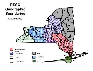
RSSC Geographic Boundaries (2005-2006). Lower Hudson Valley. Mid-State. East. Mid-West. West. Long Island. NYC. Statewide Accountability Data (2005-06). Regional Network Strategy (RNS) Regional Implementation Model 1.
Download
1 / 3
Télécharger la présentation 
Lower Hudson Valley
An Image/Link below is provided (as is) to download presentation
Download Policy: Content on the Website is provided to you AS IS for your information and personal use and may not be sold / licensed / shared on other websites without getting consent from its author.
Content is provided to you AS IS for your information and personal use only.
Download presentation by click this link.
While downloading, if for some reason you are not able to download a presentation, the publisher may have deleted the file from their server.
During download, if you can't get a presentation, the file might be deleted by the publisher.
E N D
Presentation Transcript
RSSC Geographic Boundaries (2005-2006) Lower Hudson Valley Mid-State East Mid-West West Long Island NYC
Regional Network Strategy (RNS) Regional Implementation Model1 1The implementation steps in this model are set out in a linear fashion. Actual implementation will be recursive and strategic.


More Related