Download
1 / 149
1.49k likes | 1.86k Vues
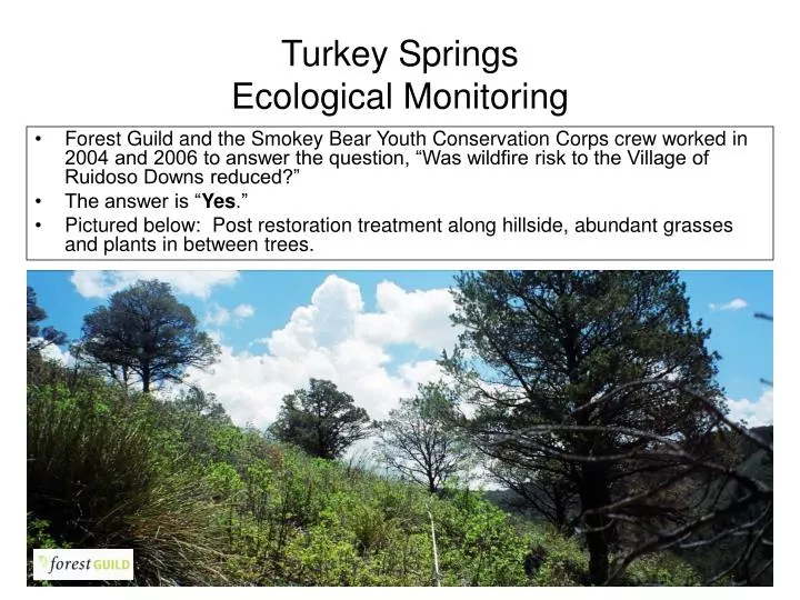
Turkey Springs Ecological Monitoring. Forest Guild and the Smokey Bear Youth Conservation Corps crew worked in 2004 and 2006 to answer the question, “Was wildfire risk to the Village of Ruidoso Downs reduced?” The answer is “ Yes .”

E N D
Turkey SpringsEcological Monitoring • Forest Guild and the Smokey Bear Youth Conservation Corps crew worked in 2004 and 2006 to answer the question, “Was wildfire risk to the Village of Ruidoso Downs reduced?” • The answer is “Yes.” • Pictured below: Post restoration treatment along hillside, abundant grasses and plants in between trees.
Turkey SpringsEcological Monitoring Before Treatment: • Trees were dense (473 trees/acre) • Canopy was closed (51% closed) • Ladder fuels abundant (199 saplings/acre)
Turkey SpringsEcological Monitoring After Treatment: • Tree Density Lowered (55 trees/acre, 88% reduced) • Canopy was opened (22% closed, 83% reduced) • Ladder fuels removed (11 saplings/acre, 94% reduced)
Turkey SpringsEcological Monitoring Youth: • 15 members of the Smokey Bear YCC Crew were trained in ecological monitoring in 2004 and 2006 and collected all ecological data Sampling: • 36 tree plots equaling 32,400 ft2 or .75 acre were sampled • 60 canopy cover plots read (densiometer method)
Hazardous Fuels Reduction & Wildland-Urban Interface ProjectsMescalero Apache Tribe Division of Resource Management & Protection Thora Padilla, Program Manager Sharon Paul, Supervisory Forester Lyman Shendo, Field Supervisor Mike Bigmouth, Crew Boss Mark Hicks, Crew Boss 3/10/2014 5
Mescalero, NM: 1892 to 2003 • Changes in the Landscape: • Increased tree density • Encroachment into meadows & wetlands • Reduction in wetlands due to Civilian Conservation Corps projects (1930’s) • Introduction and proliferation of non-native species, such as Chinese Elm 3/10/2014 6
Mescalero, NM in 1892 3/10/2014 7
Mescalero, NM 111 years later → 2003 3/10/2014 8
“Thinning” Project Goals Create a spatial arrangement of treatments that will modify fire behavior. Develop and maintain defensible spaces around residential and other developed areas. Beneficial “Side Effects” Restoring historic landscape conditions & ecological functions Restoring fire regimes Increasing water yield? Collaborative partnerships with Bureau of Indian Affairs, US Forest Service, Village of Ruidoso, NM State Forestry & Industry 3/10/2014 9
Focus on leaving large trees in treatment areas such as Skyline Fuel Break. 3/10/2014 10
Skyline Fuel Break also resulted in enhanced wildlife usage. 3/10/2014 11
Treatment results in large amounts of slash on the ground. The dilemma is often how to treat or remove material economically. 3/10/2014 12
Prescribed burning can be used to treat slash in thinning areas and improve range conditions. 3/10/2014 13
Peña Canyon Housing Area Fuels Treatment to Create “Defensible Space” 3/10/2014 14
Hand crews with chainsaws, thinning behind the Golf Course at Inn of the Mountain Gods WUI Project. 3/10/2014 15
Chipping slash in high visual quality area adjacent to Inn of the Mountain Gods. 3/10/2014 16
Masticating equipment used to treat Piñon-Juniper encroachment into meadows. 3/10/2014 17
PJ treated with masticator, near residential areas in Mescalero. 3/10/2014 18
Koller K-300 Yarder is used to treat steep slopes, such as US70 corridor north of Apache Summit. 3/10/2014 19
Wildfire and forest health concerns at the southern boundary of the reservation. Mescalero Apache Reservation Lincoln National Forest 3/10/2014 20
16 Springs Stewardship Contract between the Mescalero Apache Tribe and the Lincoln National Forest was authorized under the Tribal Forest Protection Act, allowing the Tribe to address concerns for catastrophic wildfire and forest health along the southern reservation boundary. 3/10/2014 21
DRMP Project Accomplishment(since 1999) HFR & WUI Treatments (on-reservation) 16,193 acres Forest Stand Improvement (following commercial harvest) 21,982 acres US Forest Service lands, 16 Springs Stewardship Contract (signed in 2006) 1,335 acres 3/10/2014 22
3/10/2014 23
'Ixéhe For more information call Division of Resource Management & Protection at (575) 464-4711. 3/10/2014 24
Turkey Springs Canyon Fuels Reduction and Forest Restoration Project 2004 CFRP South Central Mountain RC&D Council Clark Taylor
Statement of Need • The existing topography, heavy fuel load, and semi-arid windy weather patterns create a deadly wildfire situation • Communities at risk include Mescalero Apache Reservation, City of Ruidoso Downs, Village of Ruidoso, and Lincoln NF
Project Partners • South Central Mountain RC&D Council • Mescalero Apache Tribe • City of Ruidoso Downs • New Mexico State Forestry – Capitan District • Lincoln NF – Smokey Bear Ranger District • SBS Woodshavings, Inc.
Objective - proposed • Reduce the threat of large, high intensity wildfires, negative effects of excessive competition between trees by restoring ecosystem functions, structures, and species competition, including the reduction of non-native species populations
Objective - accomplished • 313 acres of ponderosa pine stands thinned on Mescalero Apache Reservation, New Mexico • 50 acres of pinon-juniper woodland thinned on City of Ruidoso Downs, New Mexico • 450 acres of pinon-juniper woodlands thinned on LNF-Smokey Bear District • 100 acres of ponderosa pine stands thinned on private property with assistance from NM State Forestry
Objective - proposed • Re-establish fire regimes approximating those that shaped forest ecosystems prior to fire suppression
City of Ruidoso Downs • The thinning was designed to reduce pinon-juniper tree density and extent canopy cover • Treatments were intended to alter forest structure to inhibit crown fire that threatened homes/businesses
Objective - accomplished • Fuel loads are maintained with low intensity fires that are a functional part of pinon-juniper and ponderosa pine ecosystem processes
Objective - proposed • Improve the use of or add value to small diameter trees
Objective - accomplished • 35 loads of small diameter trees removed from thinning sites to manufacturing plant
Objective - proposed • Watershed rehabilitation
Purpose • To reduce the sediment load that could reach the Rio Ruidoso, a state classified impaired cold water fishery • The project consist of: • Boulder retaining structures • Rock and wire checks • Planting native trees/shrubs
Mescalero Apache Reservation • The Resource Management & Protection Division of the Mescalero Apache Tribe, in conjunction with BIA, marked, thinned, and monitored their acreage for fuel reduction and future timber production.
Monitoring – existing conditions • Ponderosa pine stands were heavily stocked with an average 1600 trees/acre resulting in a basal area in excess of 150 square feet/acre • Pinon-juniper woodlands are overstocked with trees in excess of 200 square feet basal area/acre
Monitoring • The Forest Guild was contracted to enter, analyze, and interpret ecological data collected by the Forest Guild and Smokey Bear District YCC crews in 2004 and 2006 • Monitoring protocols were used from Handbook 4-Monitoring Ecological Effects (Derr et al. 2004) • Ecological Monitoring Report prepared by Eytan Krasilovsky
City of Ruidoso Downs • Ecological indicators were: • Adult tree density, size (<5”dbh),species and live/dead • Sapling (>5”dbh), <4.5’ height) species and density • Percent under story cover-plant, bare soil (excluding rock), and litter categories • Photo points • Extent canopy cover
City of Ruidoso Downs • 14 local youth working with the Smokey Bear District YCC were trained in ecological monitoring methods • Quantitative data was acquired from 6 transects containing 36 tree sub-plots
What was affected in the stand by the prescription? • It is unclear from % ground cover data (due to possible errors in recording) if the site conditions are favorable for low–intensity surface fire • Reduction in canopy cover was achieved and will reduce the threat of large, high intensity crown dominated wildfire
Discussion – ecological monitoring • Many of the grant objectives were met: • Reduced tree density/basal area mitigates effects of fuel and likelihood of a crown fire • Reduced tree competition • The mean adult pinon live tree size indicates that old/live trees are preserved • Sapling size trees density was reduced by 94% and mitigated effects of ladder fuels • The most significant change measured was the reduction in canopy cover
Thank you Clark Taylor South Central Mountain RC&D Council PO Box 457 Carrizozo, NM 88301 (505) 648-2941 ext 105 clark.taylor@nm.usda.gov
Ruidoso, New Mexico Ruidoso, New Mexico
By studying tree rings and fire scars of large old trees, snags and stumps, forest scientists have been able to determine the frequency of fire before extensive European settlement in New Mexico Dendrochronology
Species Frequency Pinyon-Juniper 10 - 30 years Ponderosa pine 2 – 10 years Mixed Conifer 5 – 25 years Spruce/Fir 150+ years Pre –Settlement Fire By studying tree rings it became apparent that ponderosa pine forests historically experienced frequent low intensity ground fires
What stopped the frequent low intensity ground fires? • Heavy grazing beginning around 1870 and lasting several decades reduced the grass cover that carried the ground fires