1 / 59
590 likes | 786 Vues
This is the first PowerPoint of this six PPT series covering the NSW Year 7 Geography syllabus.

E N D
Topic 1 - Landscapes and Landforms Sub Topic 1 – Landscapes and Landforms
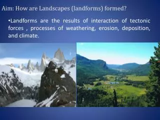
Landscapes and Landforms Main focus • The Earth is made up of many different types of landscapes and their distinctive landform features, which are shaped by geomorphic processes. Why it’s relevant to us • Geomorphic processes directly impact people. Sustainable human use of land resources depends on knowing how landscapes develop and change. Inquiry questions • What are the different types of landscapes and landforms? • Do different rocks produce different landforms? • In what ways do weathering and erosion contribute to landform development? • What were the effects of the Tambora volcano eruption in 1815?
Let’s begin Let’s begin • Geography is an important subject as it is the study of places and the relationships between people and their environments. • A landscape is an area, created by a combination of geological, geomorphological, biological and cultural layers that have evolved over time e.g. riverine, coastal or urban landscapes. • Landforms are the individual surface features of the Earth identified by their shapee.g. dunes, plateaus, canyons, beaches, plains, hills, rivers, valleys.
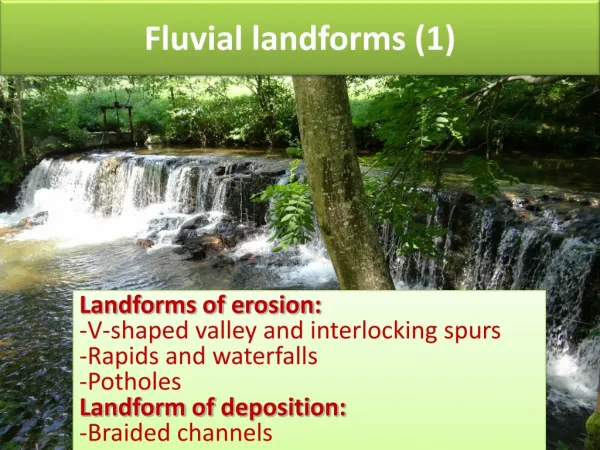
Different landscapes and landforms • Landforms of varying sizes and shapes, when taken together, are referred to as a landscape. • Landscapes can be seen and studied on topographic maps. • There are many different types of landscapes, including but not limited to: • coastal landscapes • riverine landscapes • arid landscapes • mountain landscapes • karst landscapes (Karst is a topography formed from the dissolution of soluble rocks such as limestone, dolomite, and gypsum. It is characterized by underground drainage systems with sinkholes and caves). • See definitions on the next slide..
Different landscapes and landforms • Landforms within each landscape have distinctive features. In downstream riverine landscapes, for example, landforms will include a channel, possibly a levee, and a flood plain or terrace. • Some landforms, like the arid zone dunes found in the Arabian Peninsula or central Australia, are very large and can extend for hundreds of kilometres. • Other landforms, like individual pedestal rocks shaped like an anvil or mushroom, are generally small and reach only a metre or so in height. • Geographers and others try to explain these differences in size, shape and grouping of landforms.
ICT Activity - worksheet • Using pages 51-52 Oxford Insight Geography and/or the Internet (on your device) to help you fill in the worksheet. • The worksheet can be found on Google classroom (or you can create a similar table)
Geomorphic processes • The geomorphic processes that produce landforms are both large and small in scale. • The Earth’s entire surface, whether exposed as landmasses or lying beneath the ocean, is constantly being changed by a combination of constructive and destructive forces acting at different rates; it is affected by weathering, erosion, deposition and tectonic activity.
Geomorphic processes • Large-scale plate movements, tectonic uplift and volcanic eruptions contribute to new or higher areas of ground. • At the same time, these surfaces are continuously being worn down by weathering and erosion, and the products of these processes accumulate as sediments in lower parts of continents and oceans. • Both constructive and destructive forces are operating, but with different intensities and effectiveness at different times and in different places. • When we look at landforms, we are seeing features that have evolved over time in response to different forces acting on them.
Weather and climate • People often use the terms ‘weather’ and ‘climate’ interchangeably, believing they mean the same thing. They certainly are related, but their meaning is quite different. https://www.youtube.com/watch?v=YbAWny7FV3w
Weather and climate Weather refers to the short-term conditions in a certain location. Our weather comes from the layer of the atmosphere closest to the earth’s surface, called the troposphere, and is largely driven by air pressure. Day-to-day weather conditions vary in terms of: • temperature • wind speed and direction • cloud cover • precipitation (rain, hail, snow) • humidity.
Weather and climate • Climate, on the other hand, refers to long-term patterns in a region. • Meteorologists collect weather data over time and can determine trends such as seasonal ranges in temperature and average annual rainfall. • For example, Darwin is classified as having a tropical climate based upon longterm data collected (over months and years). • In comparison, Sydney’s climate is described as ‘temperate’. • This means that the city tends to experience warm days in summer and cool days in winter.
Weather and climate • Weather is more immediate and short term, whereas climate refers to the long-term patterns. • You could also describe climate as being the ‘average’ of all the weather for a particular region.
Weather and Climate - Weathering and Erosion • Weathering and erosion are closely linked biophysical processes, sometimes being so connected that it can be difficult to separate them. • On a windy day at the beach, sand grains will impact against bare legs and do the same to any rocks exposed nearby. • Loose grains on rock surfaces will then be removed and transported by the wind. • If local topography is sloping and water erosion is active, weathered materials will be transported away from their original site and moved further downslope. • Sometimes sediments will be transferred directly into drainage networks, but more usually sediment transport on hill slopes is a ‘stop–start’ operation, with temporary storage points in small depressions or flatter areas. • Sediment that enters drainage lines following heavy rainfall will make the water turbid; this water becomes visible in estuaries and in any rivers entering the sea. https://www.youtube.com/watch?v=R-Iak3Wvh9c https://www.youtube.com/watch?v=exS9gFXgib0
A landscape produced through soil erosion around Lake Bogoria, Kenya
Weathering and Erosion Questions… 1 - Identify sites in your local area that have been affected by weathering and erosion. 2 - Outline how weathering and erosion alter the Earth’s surface. 3 - Research via the internet and then list some iconic landforms and landscapes that have been affected by weathering and erosion.
Weather and Climate – Deposition -In coastal landscapes • Coastal landscapes are formed by weathering, erosion and deposition. • Ocean currents and tides play large roles in these processes. • For most people, the coast means the beach. Beaches can be composed of quartz sands, calcareous sands (broken pieces of shells), volcanic (black) sands or boulders. • The material making up beaches comes from a combination of rock weathering along the coastline, through hydraulic action moving sediments from the continental shelf to the beach, and rivers depositing their load in the ocean. • Sand or other sediment can be moved along a coastline by ocean currents (longshore drift) and be shifted from one end of a beach to the other. https://www.youtube.com/watch?v=4RiHd4c1F8c
Weather and Climate – Deposition -In coastal landscapes • Ocean currents are large-scale, uninterrupted flows of seawater that follow a definite path. • Currents can be either mainly at the surface or in ocean depths. • At the surface, the ocean currents are mainly driven by winds. • At depths of more than 400 metres the movement of seawater is controlled by temperature and salinity differences. World map of ocean currents
Weather and Climate – Deposition -In coastal landscapes • Each of the major oceans has its own system of currents due to continents interrupting oceanic flows. • As there are no continents to obstruct currents flowing around Antarctica, the west wind drift is the only uninterrupted global current. The Disney character Nemo, a clownfish like this one here, used the Eastern Australian Current (EAC) on his journey in the cartoon film Finding Nemo.
Weather and Climate – Deposition -In coastal landscapes • Tides are caused mainly by the gravitational pull of the moon. • A high tide will happen when the moon and sun are aligned, and the largest tides during the year are recorded when the Earth is closest to the sun. • When tidal ranges are very large, there are usually local topographic and seabed features that contribute. The Hopewell Rocks at the Bay of Fundy, in New Brunswick, Canada. The Bay of Fundy has the largest tidal range (15 metres) in the world.
1.43 m 9 m 0.021336 m
Coastal Landforms Research Activity • Choose two places on the coast in Australia, one in northern Australia and one in southern Australia. • Describe the coastal landforms in each area. • Identify any differences in landforms between the two areas. • Explain why coastal landforms may not all be the same in northern and southern Australia.
Weather and Climate – Deposition -In riverine landscapes • Both deposition and erosion are processes that occur in rivers. • Large-scale deposition usually happens in the downstream or slow-moving sections of rivers, while major erosion tends to be concentrated in the upper reaches. https://www.youtube.com/watch?v=8ISfVu8Y-GY
Weather and Climate – Deposition -In riverine landscapes • Large rivers can temporarily deposit sediment within their channels, usually as a result of meandering or when the river flow slows down and is unable to keep moving all the sediment delivered to the stream. • Large rivers entering the sea often carry massive amounts of clay, silt and sand, and these are deposited at the river mouth in the form of a delta.
Deposition and Rivers Research Question What type of deposition has occurred in one of Australia’s rivers??? The Finke River is an example of deposition as it deposits various types of sediment throughout it’s water body.
Weather and Climate – Deposition -In arid landscapes • About 70% of Australia is classified as arid or semi-arid due to our low rainfall. • In Australian deserts, such as the Simpson Desert, there are many dunes. Sand particles are transported and deposited by aeolian(wind) processes, often forming interesting patterns such as longitudinal dunes, crescent-shaped dunes, star-shaped dunes and transverse dunes. https://www.youtube.com/watch?v=kH-W_2w1WzI
Deposition and Erosion in Deserts Questions 1 - Discuss how rivers are agents of both erosion and deposition. Refer to distinct features you might expect to see as evidence of these processes. 2 - Identify why deserts are generally found at a latitude of 30° north or south of the Equator. Explain why deserts are mostly located on the western side of continents or inland. 3 - Reflect on whether deserts are always hot and dry (with the exception of the Gobi Desert and Antarctica).
Weather and Climate – Deposition -In karst landscapes • Karst generally refers to the system of caves and fissures underground and their unique environments. • More specifically, it refers to a situation when water infiltrates into the Earth’s surface in sufficient quantities, and moves down to a zone of saturation, the upper limit of which is termed the water table. • Groundwater moves more slowly than overland flow, as groundwater can only circulate through small, interconnected pore spaces within rock or sediment, but it can still contribute to the formation of landforms. A karst landscape. These landscapes are characterised by eroded rock formations that result in caves and sinkholes.
Weather and Climate – Deposition -In karst landscapes • In limestone terrain, bedding and joint planes allow surface water to enter and take calcite into the solution, thereby widening any existing weaknesses or fractures. • Over time, this may lead to the development of underground streams, which emerge either as springs or as fully fledged rivers fed by underground water. • Freshwater springs appear in the ocean off the coast of Montenegro in the Adriatic Sea, and offshore from Yucatán in the Gulf of Mexico.
Weather and Climate – Deposition -In karst landscapes Limestone regions and those with soluble rocks like gypsum have often developed distinctive karst topography due to the action of underground water. On the surface, small-scale features like karren are common. At a slightly larger scale, various other features appear: sinkholes, disappearing streams and springs. More extensive landforms, like limestone pavements, karst or flat-bottomed valleys and tropical-region tower karst, also occur. When dense, compacted limestone is uplifted, gorges can be cut through the rock. Because surface water tends to disappear quickly into limestone terrain through bedding planes and joints, and then enlarge them, another characteristic of limestone regions is the development of extensive cave systems.
Formations of karst: https://www.youtube.com/watch?v=XMgattdqc_I
1. Suggest what conditions lead to the formation of a desert. 2. Describe how mountains are formed. 3. List two landforms developed in limestone by groundwater, and two developed in non-limestone areas. 4. Explain why groundwater is so important to landform development in limestone terrain. Questions
Weather and Climate – Deposition – Tectonic Activity • Plate tectonics movements tend to influence the formation of mountains over millions of years. • Tectonic plate movements occur both on continents and on ocean floors.
Weather and Climate – Deposition – Tectonic Activity and volcanoes • Volcanic activity occurs along collision, convergent and divergent plate boundaries, both under the oceans and on landmasses, and along fault lines. • Transform plate boundaries, where plates move past each other, generally are not associated with volcanic activity. • Much of the volcanism found along convergent plate boundaries is explosive, while most volcanic activity taking place along divergent boundaries involves non-explosive outpourings of lava.
Weather and Climate – Deposition – Tectonic Activity and volcanoes https://www.youtube.com/watch?v=1PVMs2NSdmc https://www.youtube.com/watch?v=R3T8wM_4Fis https://www.youtube.com/watch?v=DrwYtGf40hA As many convergent plate boundaries are on or near landmasses, explosive volcanism is what people generally experience. The ‘Ring of Fire’ around the Pacific Ocean represents more than 1000 volcanoes that have appeared on convergent plate boundaries. Of those volcanoes that have erupted during historical time, the highest is in the Andes in northern Chile, at an elevation of nearly 7000 metres. There is evidence of submarine volcanism having taken place over the last 150 years at depths of about 5300 metres in the Mid- Atlantic Ridge (divergent plate boundary).
Copy the graphic organiser below and give an example of each boundary type and associated landforms. Remember!!! Use the internet to search for your answers!!!
Examining a landscape and its landforms - Mountain landscapes • Generally mountains are formed due to collision plate boundaries. • These boundaries occur when plates are moving towards one another, resulting in the plates colliding. • Even though plates are moving slowly, they often adjust quickly, causing earthquakes.
Examining a landscape and its landforms - Mountain landscapes If the plates have approximately the same rock density, the collision forces parts of the landmasses upwards. The top of a fold is known as an anticline, whereas the bottom of the fold is the syncline, which represents the nearby rocks that have been squeezed downwards into a convex shape. Monoclines are a more simple and gentle fold – for example, the Lapstone Monocline at the eastern part of the Blue Mountains Range in New South Wales. Recumbent folds are those that have folded over themselves or overturned (‘reclining’), so that initially the youngest rocks are on the surface. Recumbent folds are frequently sighted in strongly folded terrains like the European Alps.
Matterhorn in the Swiss Alps, part of the European Alps, which has many examples of recumbent folds