Download
1 / 18
1.08k likes | 3.13k Vues
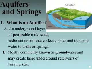
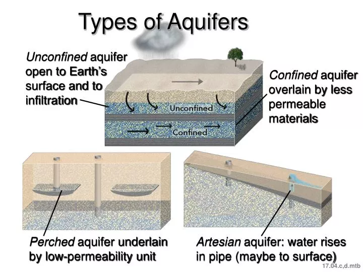
Types of Aquifers. Unconfined aquifer open to Earth’s surface and to infiltration. Confined aquifer overlain by less permeable materials. Perched aquifer underlain by low-permeability unit. Artesian aquifer: water rises in pipe (maybe to surface). 17.04.c,d.mtb.

E N D
Types of Aquifers Unconfined aquifer open to Earth’s surface and to infiltration Confined aquifer overlain by less permeable materials Perched aquifer underlain by low-permeability unit Artesian aquifer: water rises in pipe (maybe to surface) 17.04.c,d.mtb
How Does Water Move Between the Surface and Subsurface? Water can soak into subsurface and become groundwater Water table generally below surface, so water can seep in Where water table intersects surface, water can flow out 17.05.a1
How Are Lakes and Wetlands Related to Groundwater? Observe the settings of lakes compared to the water table Perched above water table Wetlands at water table or perched Water table intersects surface On topographic bench Valley bottom 17.05.c1
How Do Streams Interact with Water Table? Observe how each stream relates to water table and flow of groundwater Stream lower than water table: gains water Stream higher than water table: loses water Mound of groundwater below stream from water flowing into subsurface 17.05.d
How Do Caves Form? Most in limestone (soluble) Groundwater dissolves material Above water table, cave may be dry Features widen to cavities and caves Below water table water further dissolves material 17.06.a1
What Features Accompany Caves? Roof collapse can form sinkhole on surface Dripping water evaporates, precipitates calcite Cave formations on roof, floor, and walls Surface with sinkholes, limestone pillars, disappearing streams = karst topography 17.06.c1
How Do We Study Groundwater? Field studies: sequence and character of rocks Measure discharge, losses/gains, and water quality Geophysical surveys: depth to bedrock and water Drilling: verify geology, depth to water table, provide samples, pump tests 17.07.a1
How Do We Depict the Water Table? Numbers show elevations of the water table: what is the pattern? Compare water table to other features Contour: water table at same elevation; blue arrows show flow 17.07.b
Effects of Overpumping Groundwater Before overpumping After pumping: cone of depression 17.08.a
Other Problems of Overpumping Water table drops, aquifer compacts, land subsidence Earth fissures Along coast: freshwater floats on saltwater, so draw in saltwater 17.08.b,c
How Can Water Become Contaminated? Identify possible sources of surface water and groundwater contamination Factory wells, spills, emissions Mining and naturally mineralized rock Fuel storage tanks Landfill Dry cleaner Farm Households Septic tank Brought by river Leaking tank in gas station Truck fuel spill Brought from outside area by groundwater 17.09.a1
How Does Groundwater Contamination Move? With groundwater down water table Can be filtered if flows slowly, like through sands Not filtered if flows rapidly, like in limestone caves 17.10.a
How Do We Track and Remediate Groundwater Contamination? Spreads out due to diffusion and mixing, forming contamination plume Contour water table and contamination Drill wells to intercept plume, pump and treat water 17.10.c
Setting of the Ogallala Aquifer Unconfined aquifer; water levels dropping in south; some parts may run dry (graphs below) 17.11.a
Ogallala Water Supplies and Usage Thickest in north More rain in east Water table decline greatest in south (Kansas & Texas) 17.11.b-c