Download
1 / 35
350 likes | 834 Vues
Chapter 2 - Map Projection. Week 2 Spring 2007. Introduction. Same coordinate system is used on a same Data Frame in ArcMap Projection - converting digital map from longitude/latitude to two-dimension coordinate system. Re-projection - converting from one coordinate system to another

E N D
Chapter 2 - Map Projection Week 2 Spring 2007
Introduction • Same coordinate system is used on a same Data Frame in ArcMap • Projection - converting digital map from longitude/latitude to two-dimension coordinate system. • Re-projection - converting from one coordinate system to another • Certain map projections are better than others for representing different parts of the earth’s land area. Such as, the Albers conical equal-area projection is uniquely suited for portraying the United States.
Measuring Earth’s Circumference • Pythagoras(6 B.C.) and Aristotle(4.B.C.) decided the earth was round. • Eratosthenes (276-194 B.C.)-calculated the equatorial circumference to be 40,233 km and today’s measurement is 40,072 km. Error = 161/40072 = 0.4%
Size and Shape of the Earth • Shape of the Earth is called “geoid” Newton and Huygens stated earth was flattened at the poles and bulged at the equator. • The sciences of earth measurement is called “Geodesy” • “ellipsoid” - reference to the Earth shape. b=semiminor axis (polar radius) f = (a-b)/a - flattening 1/298.26 for GRS1980, and 1/294.98 for Clarke 1866 a = semimajor axis (equatorial radius) The geoid bulges at the North Pole and is depressed at the South Pole
Geoid (shape of the earth) • Ellipsoid – used for showing earth shape • Clark ellipsoid of 1866, used until recently. (NAD27) • NAD (North American Datum) uses Geodetic Reference System (GRS80) reference ellipsoid.
Geographic Grid • The location reference system for spatial features on the Earth’s surface, consisting of Meridians and Parallels. • Meridians - lines of longitude for E-W direction from Greenwich (Prime Meridian) • Parallels - line of latitude for N-S direction • North and East are positive for lat. and long. such as Cookeville is in (-85.51, 36.17).
Scale • Map Scale = map distance / earth distance • RF (representative fraction) – such as 1:25,000, 1:50,000… • Compute the scale with 10-in radius globe • Scale Bar, Verbal Scale (1 in = 2 miles) • Determine scale of “1 inch to 4 miles • Scale problem – distance between two points is 5 mile, what is the scale of a map on which the points is 3.168 inches apart?
DMS and DD (sexagesimal scale) • Longitude/Latitude can be measured in DMS or DD, • For example in downtown Cookeville, a point with (-85.51, 36.17) which is in DD. To convert DD to DMS, we will have to do several steps: for example, to convert -85.51 to DMS, • 0.51 * 60 = 30.6, this add 30 to minute and leave 0.6. • 0.6 * 60 = 36, this add 36 to seconds. Thus, the longitude is (-85o30’36”)
Exercise - convert New York City’s DMS to DD • New York City’s La Guardia Airport is located at (73o54’,40o46’). Convert this DMS to DD.
Exercise - convert New York City’s DMS to DD • New York City’s La Guardia Airport is located at (73o54’,40o46’). Convert this DMS to DD. • 54/60 = 0.9 and 46/60 = 0.77 • (73.90, 40.77) is the answer.
Applications of GPS • Location Identification – find out where you are in a big city or highway • Travel – find out distance to the next exit • Survey – streets, building, school, etc. • Forest – where are you now? • Boating/Fishing – locations • Aviation – landing, navigation • Defense Industry – where is the target?
SVs (Space Vehicles) • GPS Constellation consists of 24 satellites that orbit the earth in 12 hours. There are more than 24 operational satellites as new ones are launched to replace older. • Six orbital planes (4 sat. each), 20,200 km altitude, equally spaced (60o apart), and inclined at about 55o with respect to the equatorial plane, which provides 5-8 SVs visible from any point on the earth
Exercise • Copy Jan19P1.xls to your folder from G:\4210\Data\GPS • Start ArcMap • Use Tools|Add XY Data…. • Select Jan19P1.xls from your folder. • Latitude and Longitude will be automatically shown on the X and Y field. • You may now confirm your coordinate system. (undefined coordinate system…Click –Edit – Select – Geographic Coordinate Systems – World – WGS 1984.prj)
You may simply ignore this message by clicking OK. Now you have chance to view the points in DMS. You can change your dataframe coordinate system to UTM16 to view the point in meters. However, the GPS points are still in WGS1984.
Length of Parallels/Angular/Great Circle • Length of parallels = cos() * length of equator • Meridians and parallels intersect at right angles. • Loxodrome – meridians, parallels and equator all have constant compass bearing. • Great circle arc – shortest distance between 2 points on earth, formed by passing a plane through the center of the sphere. • All meridians and equator are great circle. (Is Loxodrome a Great Circle?) • Small Circle – circles on the grid are not great circle. Parallels of latitude of small circle (except equator). • Travel along N-S is the shortest, but not E-W (except along equator) • Azimuth – angle between great circle and meridian (fig 2.10). The azimuth from A to B is the angle made between the meridian passing through A and the great circle arc passing from A to B. Measuring clockwise from geographic north, although possible from the south.
Measure Distance on a Spherical Surface • cos D = sin a * sin b + cos a * cos b * cos c • where D is the distance between A and B in degrees • a is the latitude of A, b is the latitude of B and c is the difference in longitude between A and B. • Multiply D by by the length of one degree at the equator,which is 69.17 miles. For example: • Between Cookeville and New York City, we have a = 36.17, b=40.77, and c = -85.51 - (-73.90) = - 11.61 • cos D = sin36.17 * sin 40.77 + cos 36.17 * cos 40.77 * cos (-11.61) = 0.988, cos-1 0.988 = 8.885 • Distance = 8.885 * 69.17 = 615 miles
Exercise • Add another Dataframe to your current ArcMap Project. • Add layers (cities/contiguous-states) from G:\4210\Data\ESRIDATA\USA to the current dataframe. • Find Cookeville and New York (use Selection | Select By Attribute to select ‘New York’) and find their distance and you will get decimal degrees. So, you need to change the measuring unit from the little tool icon shown in the measuring window.
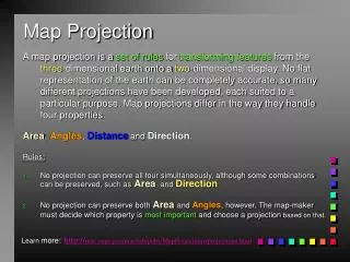
Projection – to represent the earth as a reduced model of reality • Transformation of the spherical surface to a plane surface. Graticule – meridians and parallels on a plane surface. • Projection Process (fig 2.12) • Best fit (earth geoid) • Find a “Reference ellipsoid” and reduce to • “Generating globe” then • Map projection (2D surface)
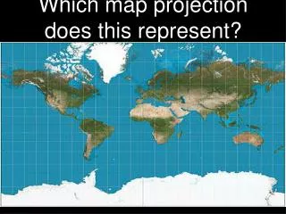
Map projections • Surface Transformation and Distortion caused by tearing, shearing and compression from 3D to 2D. • For a large scale map, distortion is not a major problem. However, the mapped is larger, then distortion will occur. • Conformal - preserves local shapes • Equivalent - preserves size • Equidistant - maintain consistency of scale for certain distance • Azimuthal - retains accurate direction • Conformal and Equivalent - mutually exclusive, otherwise a map projection can have more than one preserved property
Projections • Equal-Area Mapping - distort Shape, but important in thematic mapping, such as in population density map. • Conformal Mapping – shapes of small areas are preserved, meridian intersect parallels at right angles. Shapes for large areas are distorted. • Equidistance Mapping – preserve great circle distances. True from one point to all other points, but not from all points to all points. • Azimuthal Mapping – true directions are shown from a central point to other points, not from other points to other points. This projection is not exclusive, it can occur with equivalency, conformality and equidistance.
Measuring Distortion • Overlay shapes on maps (fig 2-14) (angular distortion value: 2ω
Distortion • Tissot’s indicatrix (fig 2-15) • S=max. areal distortion, if S= 1.0, no area distortion • a=b conformal projection. S varies • ab not conformal
Simple Case Secant Case Conic Cylindrical Azimuthal
Standard line - the line of tangency between the projection surface and the reference globe • Simple case has one standard line where secant case has two standard lines. • Scale Factor(SF) - the ratio of the local scale to the scale of the reference globe • SF =1 in standard line. • Central line - the center (origin) of a map projection • To avoid having negative coordinates , false easting and false northing are used in GIS. Move origin of map to SW corner of the map.
Planes of deformation • darker areas represent greater distortion source of data: Dent, 1999
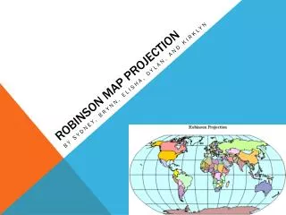
Commonly used map projections • Transverse Mercator - use standard meridians, required parameters: central meridian, latitude of origin (central parallel) false easting, and false northing. • Lambert Conformal Conic - good choice for mid-latitude area of greater east-west than north-south extent (U.S. Tn,,,,). Parameters required: first/second standard parallels, central meridian, latitude of projection’s origin, false easting/northing. • Albers Equal-Area Conic - requires same parameters as Lambert Conformal, with standard parelles at 29.5o and 45.5o is a good choice for mapping the US • Equidistant Conic - preserves distance property along all meridians and one or two standard parallels.
Spheroid or ellipsoid- a model that approximate the Earth - datum is used to define the relationship between the Earth and the ellipsoid. • Clarke 1866 - was the standard for mapping the U.S. NAD 27 is based on this spheroid, centered at Meades Ranch, Kansas. • WGS84 spheroid (almost identical to GRS80 spheroid) - from satellite orbital data. More accurate and it is tied into a global network and GPS. NAD 83 is based on this datum. • Horizontal shift between NAD 27 and NAD can be large.. HARN: High Accuracy Reference Network being developed
Coordinate Systems • Plane coordinate systems are used in large-scale mapping such as at a scale of 1:24,000. • Accuracy in a feature’s absolute position and its relative position to other features is more important than the preserved property of a map projection. • Most commonly used coordinate systems: UTM, UPS, SPC and PLSS
UTM • Divide the world into 60 zones with 6o of longitude each,covering surface between 84oN and 80oS. • Use Transverse Mercator projection with scale factor of 0.9996 at the central meridian. The standard meridian are 180 km east and west of the central meridian. • N Hemisphere: false origin at the equator and 500,000 meters west of the central meridian: • S Hemmisphere: 10,000,000 m south of the equator and 500,000 m west of the central meridian. • Maintain the accuracy of at least one part in 2500 (within one meter accuracy in a 2500 m line)
The SPC System • Developed in 1930. • To maintain required accuracy of one in 10,000, state may have two ore more SPC zones. • Transvers Mercator is used for N-S shapes, Lambert conformal conic for E-W direction. • Points in zone are measured in feet origianlly. • State Plane 27 and 83 are two systems.
PLSS • Divide state into 6x6 mile squares or townships. Each township was further partitioned into 36 square-mile parcels of 640 acres, called sections
TN Physiological Map • Spatial_Reference_Information: • Horizontal_Coordinate_System_Definition: • Planar: • Map_Projection: • Map_Projection_Name: ALBERS conical equal area • Albers_Conical_Equal_Area: • ALBERS conical equal area • Standard_Parallel: 29.5 • Standard_Parallel: 45.5 • Longitude_of_Central_Meridian: -96 • Latitude_of_Projection_Origin: 23 • False_Easting: 0.00000 • False_Northing: 0.00000 • Planar_Coordinate_Information: • Planar_Coordinate_Encoding_Method: coordinate pair • Coordinate_Representation: • Abscissa_Resolution: 1.0 • Ordinate_Resolution: 1.0 • Planar_Distance_Units: METERS • Geodetic_Model: • Horizontal_Datum_Name: North American Datum of 1983 • Ellipsoid_Name: GRS1980 • Semi-major_Axis: 6378206.4 • Denominator_of_Flattening_Ratio: 294.98
Exercise • Let’s change the coordinate system of the layer of United States from NAD1983 to Albers Equal Area -Conic • Predefined • Projected Coordinated Systems • North America • North America Albers Equal Area Conic North_America_Albers_Equal_Area_Conic Projection: Albers False_Easting: 0.000000 False_Northing: 0.000000 Central_Meridian: -96.000000 Standard_Parallel_1: 20.000000 Standard_Parallel_2: 60.000000 Latitude_Of_Origin: 40.000000 Linear Unit: Meter