Download
1 / 14
150 likes | 208 Vues
Concept of Map Projection. Map Projection.

E N D
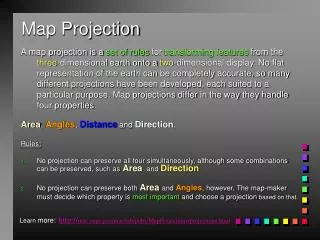
Map Projection A map projection is a set of rules for transforming features from the three-dimensional earth onto a two-dimensional display. No flat representation of the earth can be completely accurate, so many different projections have been developed, each suited to a particular purpose. Map projections differ in the way they handle four properties: Area, Angles, Distance and Direction. Rules: • No projection can preserve all four simultaneously, although some combinations can be preserved, such asArea and Direction • No projection can preserve both Areaand Angles, however. The map-maker must decide which property is most important and choose a projection based on that.
Projections and Coordinates • There are many reasons for wanting to project the Earth’s surface onto a plane, rather than deal with the curved surface • The paper used to output GIS maps is flat • Flat maps are scanned and digitized to create GIS databases • Rasters are flat, it’s impossible to create a raster on a curved surface • The Earth has to be projected to see all of it at once • It’s much easier to measure distance on a plane
Coordinate Systems • Spatial data are referenced to locations on the earth’s surface using coordinate systems • Ensure all map layers share a common coordinate system • Recognized global coordinate systems consist of: • A Spheroid: a mathematical description of the earth’s shape • A Map Projection: a mathematical conversion from spherical to planar coordinates
conformal equal area direction distance Universal Transverse Mercator (UTM) • Projection properties • All Transverse properties • Standard line is a meridian • 60 zone divided • Projection uses • World Map
Georeferencing • Is essential in GIS, since all information must be linked to the Earth’s surface • The method of georeferencing must be: • Unique, linking information to exactly one location • Shared, so different users understand the meaning of a georeference • Persistent through time, so today’s georeferences are still meaningful tomorrow
Georeferences as Measurements • Some georeferences are metric • They define location using measures of distance from fixed places • E.g., distance from the Equator or from the Greenwich Meridian • Others are based on ordering • E.g. street addresses in most parts of the world order houses along streets • Others are only nominal • Placenames do not involve ordering or measuring
Placenames • The earliest form of georeferencing • And the most commonly used in everyday activities • Many names of geographic features are universally recognized • Others may be understood only by locals • Names work at many different scales • From continents to small villages and neighborhoods • Names may pass out of use in time
Linear Referencing • A system for georeferencing positions on a road, street, rail, or river network • Combines the name of the link with an offset distance along the link from a fixed point, most often an intersection
Users of Linear Referencing • Transportation authorities • To keep track of pavement quality, signs, traffic conditions on roads • Police • To record the locations of accidents
Converting Georeferences • GIS applications often require conversion of projections and ellipsoids • These are standard functions in popular GIS packages • Street addresses must be converted to coordinates for mapping and analysis • Using geocoding functions