Download
1 / 20
200 likes | 384 Vues
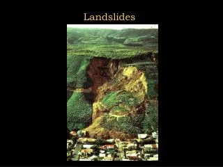
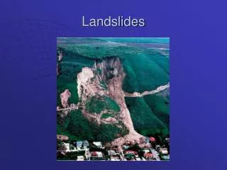
Giant landslides, topography, and erosion. Korup O. , Clague J.J. , Hermanns R.L. , Hewitt K. , Strom A.L. , Weidinger J.T. Earth and Planetary Science Letters 261 (2007) 578–589. 指導教授 : 董家鈞 老師 報告 者 : 劉正隆 日期 :2010/12/16. Introduction. C ritical hillslope height

E N D
Giant landslides,topography,and erosion Korup O. , Clague J.J. , Hermanns R.L. , Hewitt K. , Strom A.L. , Weidinger J.T. Earth and Planetary Science Letters 261 (2007) 578–589 指導教授:董家鈞 老師 報告者:劉正隆 日期:2010/12/16
Introduction • Critical hillslope height • Threshold hillslopeangle :long-term erosion rate :orogen-scale mean local relief More stable :erosion rate due to chemical weathering :rate constant :limiting relief Montgomery and Brandon (2002) More stable
Key questions • What are the relationships between topographic relief and the largest landslides on Earth ? • Are these giant slope failures fully explained by hillsloperelief ? • How do these landslides contribute to relief adjustment and erosion ?
Topographic controls on erosion rates • Powell(1876) and Gilbert(1877) recognized a strong connection between slope morphology and erosion rates. • Ahnert(1970) report alinear relation between erosion rate and mean local relief in mostly tectonically inactiveareas. • Topographic relief and erosion rates may become decoupled in tectonically active areas. Montgomery and Brandon (2002)
Topographic controls on erosion rates • Olympic Mountains - Accretion and erosion 14 Myr - High-resolution digital elevation models 10-m-grid
Topographic controls on erosion rates • shallow landsliding by debris flows (Campbell,1975) Sediment flux: Erosion rates: Montgomery and Brandon (2002) Roering et al. (1999)
Topographic controls on erosion rates • Mean slope is more strongly influenced by DEM grid size than mean local relief. (Polidori et al. ,1991) • High-resolution DEM (10-m-gird) Erosion rates: Montgomery and Brandon (2002)
Topographic controls on erosion rates • (Summerfield,1991) • SRTM30 global digital elevation data (~860m) • close to Montgomery and Brandon (2002) Montgomery and Brandon (2002)
Landslide inventory • Landslide volumes • Over 300 landslides • Satellite images and digital terrain models • Most of the largest landslides are clustered in tectonically active mountain belts and volcanic arcs. Kamchatka Caucasus TienShan Japan European Alps Pamir American Cordilleras Himalayas Central America Papua New Guinea Andes Southern Alps
Key questions • What are the relationships between topographic relief and the largest landslides on Earth ? • Are these giant slope failures fully explained by hillslope relief ? • How do these landslides contribute to relief adjustment and erosion ?
Giant landslides and topography • The topographic relief mainly produced by tectonic uplift and bedrock incision by glaciers and rivers. • More than 70% have occurred in terrain with . • More than 50% have occurred in the steepest 15% of these mountain belts.
Key questions • What are the relationships between topographic relief and the largest landslides on Earth ? • Are these giant slope failures fully explained by hillslope relief ? • How do these landslides contribute to relief adjustment and erosion ?
Giant landslides in subcritical relief • Soft rocks • Extensive low-angle discontinuities • High rates of fluvial bedrock incision • Slope loading
Key questions • What are the relationships between topographic relief and the largest landslides on Earth ? • Are these giant slope failures fully explained by hillslope relief ? • How do these landslides contribute to relief adjustment and erosion ?
Giant landslides and erosion rates • Giant landslides are responsible for 5% of the total erosion. • The contribution of giant landslides to erosion rate increases nonlinearly withmean local relief . • Giant landslides may be slightly more important contributors to total erosion in areas of lower mean local relief.
Giant landslides and erosion rates • The volume of individual giant landslides does not increase systematically with mean local relief or erosion rate. • Higherosion rates may lead to more rapid removal of geomorphic evidence and therefore potential undersampling of previous events.
Key questions • What are the relationships between topographic relief and the largest landslides on Earth ? • Are these giant slope failures fully explained by hillsloperelief ? • How do these landslides contribute to relief adjustment and erosion ?
Conclusions • About half of the largest landslides are clustered in tectonically active mountain belts and volcanic arcs where mean local relief and erosion rates are highest. • Several giant slope failures are located in areas where mean local relief is below the regional average. • The proportional contribution of giant landslides to erosion rates increases nonlinearly with mean local relief. • Numerical landscape evolution models that use critical relief thresholds for landsliding may underestimate the contribution to erosion by large events.