Download
1 / 4
40 likes | 239 Vues
In-Flight Guidance. BE CONSERVATIVE: Tactical maneuvers should remain within 12 NM of Travis AFB (Note: TZZ VOR 8.7 NM NE of KSUU) BE AWARE: Tactical maneuvers can begin from the surface or from altitudes exceeding 10,000’ MSL. Climb/Descent rates

E N D
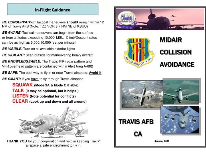
In-Flight Guidance • BE CONSERVATIVE: Tactical maneuvers should remain within 12 NM of Travis AFB (Note: TZZ VOR 8.7 NM NE of KSUU) • BE AWARE: Tactical maneuvers can begin from the surface • or from altitudes exceeding 10,000’ MSL. Climb/Descent rates • can be as high as 5,000/10,000 feet per minute! • BE VISIBLE: Turn on all available exterior lights • BE VIGILANT: Scan outside for maneuvering heavy aircraft • BE KNOWLEDGEABLE: The Travis IFR radar pattern and • VFR overhead pattern are contained within Alert Area A-682 • BE SAFE: The best way to fly in or near Travis airspace: Avoid it • BE SMART: If you have to fly through Travis airspace: • SQUAWK (Mode 3A & Mode C if able) • TALK(It may be optional, but it helps!) • LISTEN (Note potential for conflicts) • CLEAR (Look up and down and all around) • THANK YOU for your cooperation and help in keeping Travis’ airspace a safe environment to fly in MIDAIR COLLISION AVOIDANCE TRAVIS AFB CA January 2007
TRAVIS AFB MILITARY AIRCRAFT Lockheed C-5 ‘Galaxy’ Final Approach Speed: 125 Kts. Radar Pattern Speed: 210 Kts. Gross Wt: 769,000 Caution Wake Turbulence Call Signs: FRED, HEFTY, REACH McDonald-Douglas KC-10 ‘Extender’ Final Approach Speed: 150 Kts. Radar Pattern Speed: 210 Kts. Gross Wt: 590,000 Caution Wake Turbulence Call Signs: EXTENDER, GUCCI, QUEST, ORCA, TOGA, REACH Boeing C-17 ‘Globemaster III’ Final Approach Speed: 125 Kts. Radar Pattern Speed: 210 Kts. Gross Wt: 585,000 Caution Wake Turbulence Call Signs: BEE-LINER, COVERT, REACH
RUNWAY21 DEPARTURES TRAVIS AIRSPACE The airspace serviced by Travis Approach Control is used by military aircraft operating in this area, along with IFR and numerous VFR aircraft out of Buchanan Field (Concord), Napa County, Nut Tree, Yolo and four other local airports. This all leads to the increased potential for midair collisions in the Travis AFB area. Travis AFB’s mission is to provide airlift support and refueling capabilities worldwide. However, there are frequent training flights in the local area by C-5s, KC-10s, E-6s, and C-17s. In addition to these locally based aircraft, transiting aircraft like the C-130, KC-135 and T-38 fly approaches at Travis from a variety of directions, airspeeds and from altitudes ranging from 1800 to 10000 MSL. Commercial “heavy” airframes, including the Boeing 747 and 757, routinely fly into and out of Travis AFB. Travis Approach and the Travis Control Tower operate 24 hours a day, 365 days a year. Radar flight following and traffic advisories can be provided to aircraft operating north of V-150 below 5000’ MSL on 128.4 MHZ (UHF 294.7) and above 5000’ MSL on 126.6 MHZ (UHF 291.0). Operating south of V-150 on 119.9 MHZ (UHF 322.325). The tower can provide service to aircraft flying in class D airspace on 120.75 MHZ (UHF 254.4). Automatic Terminal Information Service (ATIS), is available on 116.4 MHZ (UHF 384.9). The majority of military traffic in the alert area (A-682) are in the “Heavy” category. Extreme caution should be exercised when flying in this area due to the wake turbulence these aircraft generate. A-682 lateral boundaries are depicted in yellow on the maps on the following pages. The vertical limits extend up to 6000’ MSL north of Travis’ extended runway centerline and 3000’ MSL to the south. The radar and overhead patterns are contained within its limits. If you have any questions about flying in the Travis area contact the 60th Air Mobility Wing Flight Safety Office at (707) 424-5437/1107. For more information visit the Travis AFB Midair Collision Avoidance (MACA) public website at: http://public.travis.amc.af.mil TACAN A and B (not depicted) are circling approaches used for training in the local Travis area. Approaches are flown on the SUU 12 DME arc southeast of the field and fly almost directly over Rio Vista airfield. The arc is flown at 3000 ft MSL followed by a descent down to 1800 ft MSL on the inbound legs.
TRAVIS TACTICAL REPORTING POINTS GOLF or North Entry (SUU/355/5) TZZ(SUU/031/8.7) Museum (SUU/110/4) TEALL (SUU/212/7) • Expect random maneuvering over the top of and in the vicinity of all tactical reporting points by large aircraft from 1600’ MSL up to 10,000’ MSL • High rate descents of up to 10,000 fpm are possible in the vicinity of all tactical points and Travis AFB. Aircraft are initially assigned to 6000’ MSL. Departure control 126.6 will climb the aircraft 10,000’ MSL traffic permitting and initiate a handoff to Oakland Center. Cell Departures (flights of up to four KC-10s) are common. The flights will consist of a block altitude (normally 4000 to 6000 feet) and depart in one minute intervals.