Download
1 / 1
10 likes | 114 Vues
Modeling the Impacts of Climate Change on Surface Erosion in a Dryland Agricultural Basin Erika Ottenbreit a , Jennifer Adam a , Michael Barber a , Jan Boll b , and Jeffrey Ullman c

E N D
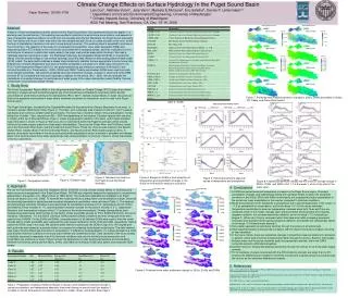
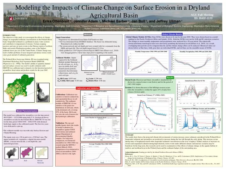
Modeling the Impacts of Climate Change on Surface Erosion in a Dryland Agricultural Basin Erika Ottenbreit a, Jennifer Adam a, Michael Barber a, Jan Boll b, and Jeffrey Ullman c a Department of Civil and Environmental Engineering, Washington State University, b Department of Biological and Agricultural Engineering, University of Idaho, c Department of Biological Systems Engineering, Washington State University Author Contacts: eottenbreit @wsu.edu and jcadam @wsu.edu AGU Fall Meeting ID: H41F-1135 Global Climate Models Methods INTRODUCTION The objective of this study is to investigate the effects of climate change on suspended sediment concentrations in the Potlatch River basin. Suspended sediment is a pollutant in many water systems and contributes to impairment of streams. Certain cropping practices and rain-on-snow events in the Palouse region of northern Idaho and eastern Washington produce some of the highest sediment losses per acre in the United States. Climate change may lead to further problems if more frequent and intense storm events cause great amount of sediment generation. The Potlatch River basin near Julietta, ID was examined using Distributed Hydrology Soil Vegetation Model (DHSVM; [Wigmosta et al., 1994]). The model’s ability to quantify channel and soil surface erosion was used to model sediment yield. DHSVM was calibrated and evaluated over the historical period of streamflow observation and predicts results for the year 2045. Global Climate Models (GCMs): Nine GCMs were chosen to be run for the year 2045. They were chosen based on a model ranking for the Pacific Northwest (Mote and Salathé, 2010). Both the GCMs were run for A1B and B1 emissions scenarios. The changes to mean monthly temperature and precipitation were analyzed for a 30 year period. The statistically downscaled future metrological data were derived by perturbing the historical record (Elsner et al., 2010). As a result, overlapping time periods can be compared directly and the climate change effect can be analyzed. Historical values are shown below as blue lines, while gray lines are individual GCMs, and red lines are the ensemble means of GCMs. • Input Generation: • Vegetation was determined from Idaho GAP landcover data. • Soil was determined from SSURGO database. The basin was delineated using Watershed tools within ArcGIS. • The stream network and soil depth grid were created with Arc commands from the DEM and mask file. The soil depth ranged from 0.5-2.0 m. • Daily gridded (to 1/16th degree) meteorological (MET) data (Elsner et al., 2010) were disaggregated to 3-hour time steps prior to inputting to the model. • Sediment Module: Inputs • required for the Sediment • Module include Manning’s n • for all soil types, d50 & d90 • sizes for debris flow and • channel parent particles, • parameters that determine • cohesiveness, and a d50 for • each soil type. • d50 Silt Loam: 0.055 mm d50 Loam: 0.206 mm • d50 Cobbly Silt Loam: 0.303 mm d50 Debris Flow: 0.06 mm Observed streams (ESRI’s TIGER lines) Modeled stream network Results Storm Event: Historical and future streamflow simulations are shown for a typical winter event (below) and for the period of 1967-1983 (right). Erosion: It is shown that most of the hillslope erosion occurs when the streamflow is within the upper 25% of daily flow volumes (bottom right). Calibration and Validation Calibration: Calibration was sensitive to lateral conductivity and exponential decay in soil conductivity. The sediment module of DHSVM 3.0 was sensitive to the grain size distribution of silt loam, which is the dominant soil, covering 95% of the basin. Silt Loam was also the soil of interest for the hydrologic calibration. Validation: The top and middle figures show the results of model evaluation for streamflow against USGS observations and sediment against Department of Environmental Quality samples. For long-term comparison, reconstructed streamflow for 1966-1984 was created using the MOVE.2 method (Hirsch 1982). Comparison of reconstructed to observed streamflow (2003-2006) is shown to the right. Model Parameterization Calibration may be improved by using observed precipitation values. • The model was calibrated for streamflow over the time period 08/15/2003 – 12/31/2006 using daily U.S. Geological Survey streamflow records for the Potlatch River. DHSVM 3.0 was run for the time period 10/01/1970 – 10/01/1976 with identical hydrologic inputs to the calibrated model. The first two years were dedicated to spin-up. • The sediment module was run with only Surface Erosion and Channel Routing. • The inputs were on a 150 m grid over a 1520 km2 area. The inputs included soil, vegetation, a digital elevation model (DEM), a stream network file, a soil depth file, and meteorological data. SUMMARY The results show that as the projected climate-driven intensity of storms increase, more sediment is predicted in the Potlatch River. Suspended sediment and streamflow are predicted to increase during the late fall through the early spring. This increase occurs during times of heightened runoff when suspended sediment concentration in the river is highest. Further analysis of increases in erosion and suspended sediment during high-intensity storm events under different climate and land use scenarios may be beneficial. In the long-term, this research can be used to examination of the effects of climate change on the aquatic habitat of rainbow and steelhead trout in the Potlatch basin and the sediment budget of the surrounding area. Acknowledgements: Funding provided by the Inland Northwest Research Alliance (INRA) References: Elsner, M., L. Cuo, N. Voisin, J. Deems, A. Hamlet, J. Vano, K. Mickelson, S. Lee, and D. Lettenmaier (2010), Implications of 21st century climate change for the hydrology of Washington State, Climatic Change, 225-260. Hirsch, R. M., 1982: A comparison of 4 streamflow record extension techniques. Water Resources Research, 18, 1081-1088. Mote, P., and E. Salathe (2010), Future climate in the Pacific Northwest, Climatic Change, 29-50. Wigmosta, M.S., L.W. Vail, and D.P. Lettenmaier (1994), A distributed hydrology-vegetation model for complex terrain, Water Resour. Res., 30, 1665-1669. DEM Soil Stream Network