Download
1 / 20
200 likes | 407 Vues
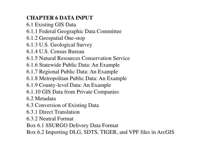
CHAPTER 6 DATA INPUT 6.1 Existing GIS Data 6.1.1 Federal Geographic Data Committee 6.1.2 Geospatial One-stop 6.1.3 U.S. Geological Survey 6.1.4 U.S. Census Bureau 6.1.5 Natural Resources Conservation Service 6.1.6 Statewide Public Data: An Example 6.1.7 Regional Public Data: An Example

E N D
CHAPTER 6 DATA INPUT 6.1 Existing GIS Data 6.1.1 Federal Geographic Data Committee 6.1.2 Geospatial One-stop 6.1.3 U.S. Geological Survey 6.1.4 U.S. Census Bureau 6.1.5 Natural Resources Conservation Service 6.1.6 Statewide Public Data: An Example 6.1.7 Regional Public Data: An Example 6.1.8 Metropolitan Public Data: An Example 6.1.9 County-level Data: An Example 6.1.10 GIS Data from Private Companies 6.2 Metadata 6.3 Conversion of Existing Data 6.3.1 Direct Translation 6.3.2 Neutral Format Box 6.1 SSURGO Delivery Data Format Box 6.2 Importing DLG, SDTS, TIGER, and VPF files in ArcGIS
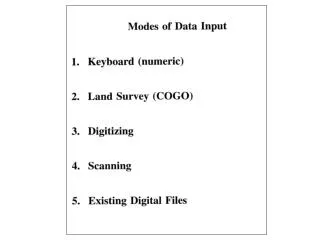
6.4 Creating New Data 6.4.1 Remotely Sensed Data 6.4.2 Field Data Box 6.3 An Example of GPS Data 6.4.3 Text Files with x-, y-Coordinates 6.4.4 Digitizing Using a Digitizing Table 6.4.5 Scanning Box 6.4 Vectorization Settings in ArcGIS 6.4.6 On-Screen Digitizing 6.4.7 Importance of Source Maps Key Concepts and Terms Review Questions Applications: Data Input Task 1: Download and Process DEM and DLG from the Internet Task 2: Digitize On-Screen in ArcMap Task 3: Add X Y Data in ArcMap Challenge Question References
Figure 6.1 The MIF to Shapefile tool in ArcGIS converts a MapInfo file to a shapefile.
Figure 6.2 To accommodate users of different GIS packages, a government agency can translate public data into a neutral format such as SDTS format. Using the translator in the GIS package, the user can convert the public data into the format used in the GIS.
Figure 6.3 A digital orthophoto (DOQ) can be used as the background for digitizing or updating of existing maps.
Figure 6.4 A bearing and a distance determine a course between two stations.
Figure 6.5 Use four GPS satellites to determine the coordinates of a receiving station. xi, yi, and ziare coordinates relative to the center of mass of the Earth. Ri represents the distance (range) from a satellite to the receiving station.
Figure 6.6 A portable GPS receiver. (Courtesy of Trimble.)
Figure 6.7 Elevation readings from a GPS receiver are measured from the surface of the geoid rather than the spheroid.
Figure 6.8 A large digitizing table and a cursor with a 16-button keypad. (Courtesy of GTCO Calcomp, Inc.)
Figure 6.9 The end of a new line can be automatically snapped to an existing arc if the gap is smaller than the specified snapping tolerance.
Figure 6.10 A point (node or vertex) can be automatically snapped to another point if the gap is smaller than the specified snapping tolerance.
Figure 6.11 Large format drum scanners. (Courtesy of GTCO Calcomp, Inc.)
Figure 6.12 A binary scanned file: the lines are soil lines, and the black areas are the background.
Figure 6.13 A raster line in a scanned file has a width of several pixels.
Figure 6.14 Semiautomatic tracing starts at a point (shown with an arrow) and traces all lines connected to the point.
Figure 6.15 The width of a raster line doubles or triples when lines meet or intersect.
Framework data http://www.fgdc.gov/framework/framework.html/ Federal Geographic Data Committee http://www.fgdc.gov/ Geospatial One-stop http://www.geo-one-stop.gov/ U.S. Geological Survey: National Map http://geography.usgs.gov/ National Land Cover Data 1992 http://landcover.usgs.gov/ USGS DEMs download sites: GIS Data Depot http://data.geocomm.com/ USGS DEMs download sites: Map-Mart http://www.mapmart.com/ USGS DEMs download sites: LAND INFO International http://www.atdi-us.com/ National Elevation Data set (NED) http://gisdata.usgs.gov/ned/
AmericaView http://americaview.usgs.gov/ OhioView http://www.ohioview.org/ U.S. Census Bureau http://www.census.gov/ Montana GIS data clearinghouse http://www.nris.state.mt.us/ Greater Yellowstone Area Data Clearinghouse http://www.sdvc.uwyo.edu/gya/ San Diego Association of Governments http://www.sandag.cog.ca.us/ Clackamas County, Oregon http://www.co.clackamas.or.us/gis/ MapInfo http://www.mapinfo.com/ Geography Network http://www.geographynetwork.com/
Geographic Data Technology http://www.geographic.com/home/index.cfm Tele Atlas North America http://www.teleatlas.com/landingpage.jsp FGDC metadata http://www.fgdc.gov/metadata/metadata.html/ Metadata tools http://www.fgdc.gov/metadata/metatool.html/ Spatial Data Transfer Standard http://mcmcweb.er.usgs.gov/sdts/ National Imagery and Mapping Agency http://www.nima.mil/ International Steering Committee for Global Mapping http://www.iscgm.org/html4/index.html USGS Geographic Data Download website http://edc.usgs.gov/geodata/ Northern California Earthquake Data Center http://quake.geo.berkeley.edu/ California GIS data clearinghouse http://casil-mirror1.ceres.ca.gov/casil/