Download
1 / 16
160 likes | 215 Vues
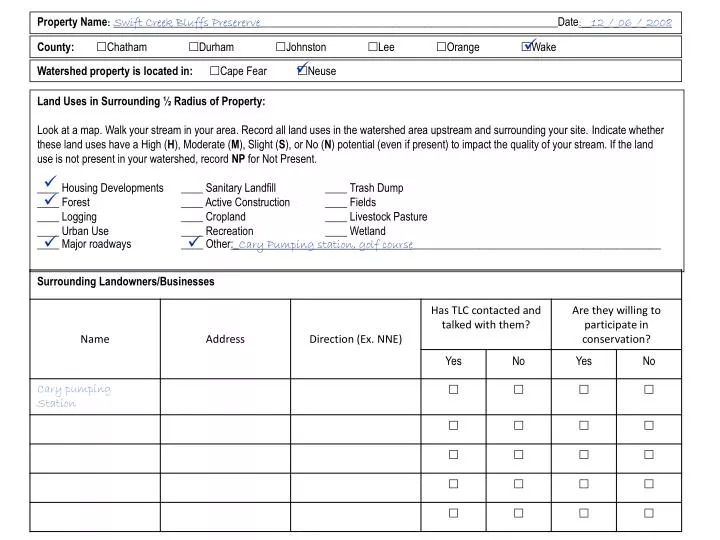
Property Name : Swift Creek Bluffs Presererve ______________________________________________________Date :__12_/_06_/_2008. . County: Chatham Durham Johnston Lee Orange Wake. .

E N D
Property Name: Swift Creek Bluffs Presererve______________________________________________________Date:__12_/_06_/_2008 County: Chatham Durham Johnston Lee Orange Wake Watershed property is located in: Cape Fear Neuse Land Uses in Surrounding ½ Radius of Property: Look at a map. Walk your stream in your area. Record all land uses in the watershed area upstream and surrounding your site. Indicate whether these land uses have a High (H), Moderate (M), Slight (S), or No (N) potential (even if present) to impact the quality of your stream. If the land use is not present in your watershed, record NP for Not Present. ____ Housing Developments ____ Sanitary Landfill ____ Trash Dump ____ Forest ____ Active Construction ____ Fields ____ Logging ____ Cropland ____ Livestock Pasture ____ Urban Use ____ Recreation ____ Wetland ____ Major roadways ____ Other:_Cary Pumping station, golf course_____________________________________________
Stream/Riparian Sampling Point 1 (Start of Stream Flow on TLC property) Describe overall appearance of riparian habitat bordering the stream: Natural, undisturbed Managed (signs of mowing, pruning, logging, etc.) Buffer contains undisturbed and managed sections Is the width of the riparian buffer at least 50 ft.? Yes No Are there any gaps in the riparian buffer between 2nd and 3rd stream sampling point? Yes No If yes, how many? __________ How steep, on average, is the riparian habitat? Mostly flat (0-6%) Slight incline (6-10%) Moderate incline (10-15%) Steep incline (>15%) Riparian Buffer Composition Woody Vegetation _35_% Trees (saplings, mature) _55_% Shrubs _10_% Tree/shrub seedlings __0_% Other: ____________ Ground Cover _15_% Grass _85_% Leaf litter/detritus __0_% Bare Soil __0_% Other: ____________ Riparian Buffer Soil Type __0_% Sand __0_% Gravel _60_% Silt _40_% Clay Soil Type Descriptions Sand: Loosely/densely packed stones measuring <¼ inches. Gravel: Loosely/densely packed stones measuring ¼ to 2 inches. Silt: Fine grain appearance; muddy texture when wet; powdery when dry. Wet and shake a small pat of the soil. If water appears on the pat’s surface but disappears after pressing the pat between fingers, soil is mostly silt. Clay: Fine grain appearance; easily molded when wet; shape retained when dry. • Riparian Buffer Design • If a forested riparian, are there more • saplings in the understory than older trees • in the canopy? • Yes No • If a forested riparian, are there canopy • gaps allowing sunlight to penetrate the • ground? • Yes No • If shrubs are present, is the shrub density • highest along the stream’s edge? • Yes No - evenly distributed • Other:_lots of downed, old logs_____ Riparian Buffer Water Saturation Dry: soil is hard and devoid of moisture Moist: soil is damp to the touch; can press thumb into the ground Wet: soil is soft but feet do not sink into the ground Saturated: soil is soft and feet sink into the ground
Date:_12/_06_/_2008_ Stream Name: __Swift Creek___________________Latitude/Longitude (GPS point):_______________________ Location: (please be specific – where on property is it located?)________________________________________________________________ Name(s) of certified monitor/participants:________________________________________________________________________________ Average stream width:__37___ft. Average stream depth:__5___in. Water temperature:_______°FAir temperature:__47___°F Stream flow rate: High Normal Low NegligableStream movement: Meander Straight Weather conditions last 72 hours:__Average temp. about 50 deg. F. Sunny to partly cloudy, no precipitation_________________ Fish: Scattered individuals Scattered schools Trout (pollution sensitive) Bass (somewhat sensitive) Catfish (pollution tolerant) Carp (pollution tolerant) None Not applicable Other:_________________ Barriers to Fish Movement: Beaver dams Man-made dams Waterfalls (>1ft) Trash buildup None Not applicable Other:_downed logs blocking flow_______________________ Surface Water Appearance: Clear Clear, but tea colored Colored sheen (oily) Foamy Milky Cloudy/turbid Muddy Other:__________________ Stream Bottom Deposit: Gray Orange/Red Yellow Black Brown/tan Silty/muddy Sandy Other:__________________ Odor: None Rotten eggs Musky Oil Sewage Other:___________________ Stability of Stream Bed: Bed sinks beneath feet in: No spots A few spots Many Spots Algae Color: No algae present Light green Dark Green Brown coated –on rocks, minimal Matted on stream bed Hairy/filamentous Algae Located: Everywhere In spots: _up to 30% of bed covered Stream Channel Shade: Full: >75% High: 50-74% (with leaves) Moderate: 25-49%(general area) Slight: 1-24% (no leaves) None: 0% Riffle Composition: (=100%) __0_% Silt (mud) _30_% Sand (1/64” – ¼” grains) _30_% Gravel (1/4” – 2” stones) _40_% Cobbles (2” – 10” stones) ____% Other :_______________ No riffles present Stream Bank Composition: (=100%) _20_% Trees _30_% Shrubs _20_% Grass _30_% Bare Soil _0__% Rocks _0__% Concrete ____% Other:__________________ Stream Bank Erosion: Severe: >75% High: 50-75% Moderate: 25-49% Slight: 1-24% None: 0%
Comments: Indicate what you think are the current and potential threats to your stream's health. Feel free to attach additional pages or photographs to better describe the condition of your stream ____Some trash was noted in areas that could potentially end up in stream due to runoff___________________________________ ____________________________________________________________________________________________________________________ ____________________________________________________________________________________________________________________ ____________________________________________________________________________________________________________________ ____________________________________________________________________________________________________________________ ____________________________________________________________________________________________________________________ ____________________________________________________________________________________________________________________ ____________________________________________________________________________________________________________________ ____________________________________________________________________________________________________________________ ____________________________________________________________________________________________________________________
Individual Metrics Metric 5: % Tolerant Metric 6: % Non-Insects
Save Our Streams Multimetric Index Write your metric value from the previous page in the 2nd column (Your Metric Value). Determine whether each metric should get a score of 2,1, or 0 – depending upon the range of your metric value. Put a check in the appropriate box for your metric value under 2,1, or 0. Count the total number of 2’s, 1’s, and 0’s. Follow the multiplication at the bottom of the chart to determine your Save Our Streams Multimetric Index score and determine whether the site has acceptable or unacceptable ecological condition.
General Shapes of Stream Fish [Image credit: http://www.floridaconservation.org/Fishing/Fishes/anatomy.html]
Trout: torpedo shape; one soft dorsal fin; small adipose fin in front of caudal fin; pectoral fin in thoracic region near underside; pelvic fin on abdomen; small, smooth scales. [Brook trout image credit: http://www.denniskalma.com/brooktrout.html] Bass: laterally compressed body; two dorsal fins that appear joined, with first dorsal fin spiny; pectoral fin in thoracic region over pelvic fin; spiny anal fin; toothed, rough scales. [Smallmouth bass image credit: http://www.denniskalma.com/smallmouthbass.html]
Bullhead Catfish: long body with bull shaped head; 4 pairs of barbels/whiskers around mouth; one fanlike dorsal fin; adipose fin in front of caudal fin; caudal fin may or not have split; long anal fin aligned closely to pelvic fin; stout spines near dorsal and pectoral fins; no scales [Yellow bullhead catfish image: http://www.dfw.state.or.us/swwd/yellow_bullhead.jpg] Carp: deep, thick, body with significant arch from head to dorsal fin; 2 barbels near mouth; long soft dorsal fin; pectoral fin in thoracic region; pelvic fin on abdomen; caudal fin with deep split, smooth scales. [Common carp image: http://upload.wikimedia.org/wikipedia/commons/a/a8/Common_carp.jpg] Reference for fish descriptions: Page, L.M. and B.M. Burr. 1991. Peterson Field Guides: Freshwater Fishes. Houghton Mifflin Company: Boston/New York. 432 pp.
http://h2o.enr.state.nc.us/admin/rules/documents/redbook_1may07_full_with_cover.pdf http://www.epa.gov/owow/monitoring/volunteer/stream/vms59.html http://www.dep.state.fl.us/water/bioassess/posters.htm#bugid
http://h2o.enr.state.nc.us/csu/documents/ncactable290807.pdf