Download
1 / 21
210 likes | 376 Vues
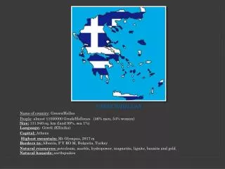
Photogrammetry and Remote Sensing in Hellas (Greece). Introduction - Εισαγωγή. Geography - Γεωγραφία History - Ιστορία Education - Εκπαίδευση Current status – Τρέχουσα κατάσταση. 1. Geography of Greece. 11.000.000 inhabitants. 132.000 km 2 area.

E N D
Photogrammetry and Remote Sensing in Hellas (Greece) Photogrammetry and Remote Sensing in Greece Yannis Yanniris MSc
Introduction -Εισαγωγή • Geography - Γεωγραφία • History - Ιστορία • Education - Εκπαίδευση • Current status – Τρέχουσα κατάσταση Photogrammetry and Remote Sensing in Greece Yannis Yanniris MSc
1. Geography of Greece • 11.000.000 inhabitants. • 132.000 km2 area. • 16,000 km coast line (half in islands). • 300 mountains. • 40 mountains height >2000m. Photogrammetry and Remote Sensing in Greece Yannis Yanniris MSc
2. History (1) 1889 the “Geodetic Mission” later “Hellenic Geographic Army Service”. 1918 Hydrographic military Service, Surveying in ministry of Transportations, Surveying in ministry of Agriculture. 1937 Photogrammetric projects. 1953 Dakota flights. 1962 mapping of Greece 1:5000 HMGS. Photogrammetry and Remote Sensing in Greece Yannis Yanniris MSc
History (2) • 1972 first computer aerial triangulation. • 1970ies, analytical instruments. • 1980ies digital photogrammetric systems. • 1990 remote sensing “CORINE” (2000). • 1990 Geographic Information Systems. • 1995 Ktimatologio S.A. is established. • 2000- Many big projects. Photogrammetry and Remote Sensing in Greece Yannis Yanniris MSc
3. Education • N.T.U.A. (National Technical University of Athens), 1917. • A.U.T (Aristotle University of Thessalonica), 1963. • T.E.I.A (Technological Educational Institute of Athens), 1980. • Other Universities and technological Institutes 1980. Photogrammetry and Remote Sensing in Greece Yannis Yanniris MSc
N.T.U.A. (National Technical University of Athens) • 100 new students every year. • Geodesy, surveying, photogrammetry, remote sensing, geography, cadastral surveying, regional planning, infrastructure, rural developement, geoinformatics. • Analog, analytical, digital instruments. • Research. Photogrammetry and Remote Sensing in Greece Yannis Yanniris MSc
A.U.T. (Aristotle University of Thessalonica) • 100 new students every year. • Geodesy, surveying, photogrammetry, remote sensing, geography, regional planning, infrastructure, rural developement. • Analog, analytical, digital instruments. • Research. Photogrammetry and Remote Sensing in Greece Yannis Yanniris MSc
T.E.I.A (Technological Educational Institute of Athens) • 80 new students every year. • Geodesy, surveying, photogrammetry,. • Analog, digital instruments. Photogrammetry and Remote Sensing in Greece Yannis Yanniris MSc
Other Universities and Technological Institutes • University of Athens, geology and geoenvironment. • Agricultural University of Athens. • A.U.T (Aristotle University of Thessalonica), Forestry dept. • Aegean University, School of the environment. • T.E.I. in geoinformation of Seres, Kavala. • T.U.Crete. Dept of mineral resources. Photogrammetry and Remote Sensing in Greece Yannis Yanniris MSc
4. Current Status • Main state organizations. • Professional organizations. • Data • Main projects. Photogrammetry and Remote Sensing in Greece Yannis Yanniris MSc
Main State Organizations (1) • Hellenic Military Geographic Service (HMGS). • Hellenic NavyHydrographic Service (HNHS). • Hellenic Mapping & Cadastral Organization (HEMCO), ministry of Environment & Public Works • Ministry of Agriculture. Directory of Surveying. • Ktimatologio SA. (Cadastral Company of the ministry of Environment & Public Works). Photogrammetry and Remote Sensing in Greece Yannis Yanniris MSc
Main State Organizations (2) Ministry of Culture. Directory of Surveying, Photogrammetry and Cadastre. Public Power Corporation SA. National Observatory of Athens. Greek Institute of Geology & Mineral Exploration. Photogrammetry and Remote Sensing in Greece Yannis Yanniris MSc
Professional Organizations • Hellenic Society for Photogrammetry & Remote Sensing (HSPRS). • Hellenic Association of Rural & Surveying Engineers (HARSE). • Technical Chamber of Greece (TCG). Photogrammetry and Remote Sensing in Greece Yannis Yanniris MSc
Professionals About 500 with studies in Photogrammetry and R.S. 6.500 Rural & Surveying engineers 110.000 engineers. Photogrammetry and Remote Sensing in Greece Yannis Yanniris MSc
Data (1) • Aerial photographs: • 350.000 (HMGO), • 300.000 (HEMCO), • 60.000 all Greece (min. of Agriculture), • 20.000 all Greece (Ktimatologio SA) • Maps: 387 sheets, 1:50.000 scale (HMGO) • Drawing: • 11.500 sheets, 1:5.000 scale (HMGO) • 4.000 km2,1:1.000 scale cities (HEMCO) Photogrammetry and Remote Sensing in Greece Yannis Yanniris MSc
Data (2) Orthophotos: ~15.000 sheets 0.5m pixel, gray, at ministry of Agriculture, ~13.500 sheets 0.5m pixel, rgb, at Ktimatologio SA, ~13.500 sheets 0.5m pixel, gray 1945 photos, at Ktimatologio SA, 16.000 km coast 0.25m pixel, rgbn, at Ktimatologio SA, 3.500 km2, 0.20m pixel, true ortho, rgb, cities, at Ktimatologio SA total Greece from satellite images, min Agriculture National Agricultural Research Foundation (N.AG.RE.F.) Photogrammetry and Remote Sensing in Greece Yannis Yanniris MSc
Data (3) DTM: all Greece 40m and 20m, at ministry of Agriculture, all Greece 5m, at Ktimatologio SA, 16.000 km coast 1m, at Ktimatologio SA, DSM: 3.500 km2, 0.80m, at Ktimatologio SA, Photogrammetry and Remote Sensing in Greece Yannis Yanniris MSc
Main Projects Hellenic Nationall Cadastre. Land Parcel Identification System (every year). Olive trees tracking. Compilation of maps. Remote Sensing projects. 3d model of Acropolis pilot project for detection of illegal buildings. Photogrammetry and Remote Sensing in Greece Yannis Yanniris MSc
HE.PO.S. Hellenic Positioning System 98 permanent GPS stations (Ktimatologio SA). Photogrammetry and Remote Sensing in Greece Yannis Yanniris MSc