Download
1 / 21
210 likes | 379 Vues
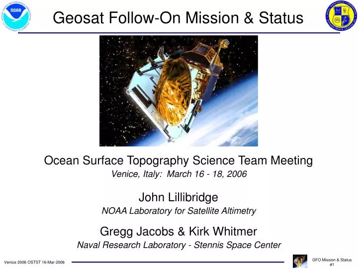
Geosat Follow-On Mission & Status. Ocean Surface Topography Science Team Meeting Venice, Italy: March 16 - 18, 2006 John Lillibridge NOAA Laboratory for Satellite Altimetry Gregg Jacobs & Kirk Whitmer Naval Research Laboratory - Stennis Space Center. GFO Spacecraft & Sensors.

E N D
Geosat Follow-On Mission & Status Ocean Surface Topography Science Team Meeting Venice, Italy: March 16 - 18, 2006 John Lillibridge NOAA Laboratory for Satellite Altimetry Gregg Jacobs & Kirk Whitmer Naval Research Laboratory - Stennis Space Center
GFO Spacecraft & Sensors • Ku-band Altimeter • Dual-ƒ Radiometer • 4 GPS Receivers • Doppler Beacon • Laser Retro-reflector • Fixed Solar Array • Solid State Memory
A Brief History • Launch: 10-Feb-1998 from Vandenberg AFB • 8-year nominal lifetime, celebrated 8th anniversary in 2006 • Initial hardware difficulties • Onboard CPU resets during first two years • GPS receivers failed in spite of 4-unit redundancy • Loss of primary orbit determination system • Loss of precision time-tagging • Ground-based time-tag unit at NAVSOC: June, 1999 • Precision orbit determination based on SLR tracking • CPU reset problems solved: November, 1999 • Navy acceptance: November 29, 2000 • Momentum wheel anomalies - temperature sensitivity
Payloads off - Thermal Issues Start of GDRs Momentum Wheel Anomaly Navy Acceptance Altimetry Data Return
Interagency Participation • U.S. Navy • SPAWAR • Program management • Navy Cal/Val team • NAVSOC • Satellite Command/Control • Data Telemetry • Operational Doppler orbits • NAVO/NRL - Stennis • Payload Operations Center - ADFC • Near real-time altimetry -> GODAE • Military data requests • NASA • Wallops Flight Facility • Instrument performance monitoring & Cal/Val • Goddard Space Flight Center • Precise Orbit Determination from laser ranging • Ice-sheet monitoring via altimeter waveforms • NOAA • Final Science-quality GDRs • Near real-time IGDRs • Civilian Data Requests (Foreign & National) • Funding OSU Cal/Val team & GSFC Orbits • Funded CLS for sea-state bias model
European Partners • CNES - Corsica absolute calibration • CLS - Real-time “DUACS” system • Validation of all corrections • Editing thresholds and engineering flags • Sea surface height, SWH, Wind & Attitude • S.O.S. (U.K.) - SWH/Wind Buoy validation
Before orbit error reduction Crossover RMS (cm) After orbit error reduction Near Real-Time AVISO Processing - GFO Courtesy: M-H. de Launay CLS
Crossover rms (m) Near Real-Time Navy ADFC Processing
GFO & T/P Sea Surface Height • SSH-MSS residuals: 11 cm for GFO; 10 cm for T/P • Geocenter offsets applied (B. Beckley/GSFC)
Improved Mesoscale Sampling Pascual, A., Y. Fauge`re, G. Larnicol, and P.-Y. Le Traon (2006), Improved description of the ocean mesoscale variability by combining four satellite altimeters, Geophys. Res. Lett., 33, 2006.
East Australia Current Analysis - CSIRO Courtesy: D. Griffin -CSIRO
Hurricane Katrina & Altimetry Scharroo, Smith and Lillibridge, EOS, 86(40), 2005
Continuing GFO Operations • GFO has reached its nominal 8-year lifetime • Navy, NOAA, & NASA will continue operations as long as possible • Two significant hardware issues to face: • Thermal sensitivity of reaction wheels • Wheel #1 taken offline: may still be viable, but requires further study • Wheel #3 sensitive to overheating • Reduced operations when orbit in “full-sun” orientation • Battery aging effects • Will reach manufacturer’s spec. on charge/discharge cycles this year • During orbital eclipse voltages approach undervoltage limit • Direct Downlink mode has been terminated (transmitter off) • Implement ‘one-failed-cell’ battery mode to lower UV limits • Place altimeter in standby for portion of eclipse (each rev…) • Power off Water Vapor Radiometer for extended periods of time