Download
1 / 18
180 likes | 323 Vues
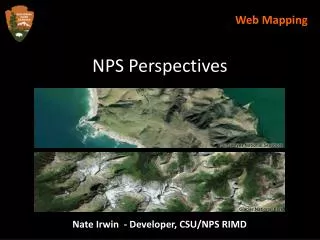
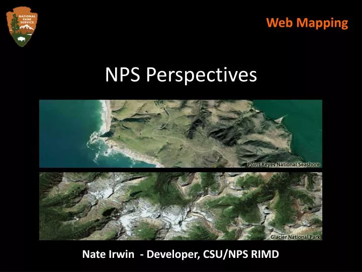
NPS Perspectives. Web Mapping. Nate Irwin - Developer, CSU/NPS RIMD. Web Mapping. Web mapping and EGIS. Our initial approach. Current and planned web map apps. Challenges that we face. Rethinking our approach. NPS use cases. Outsourcing base mapping. NPS Perspectives: What it does.

E N D
NPS Perspectives Web Mapping Nate Irwin - Developer, CSU/NPS RIMD
Web Mapping • Web mapping and EGIS. • Our initial approach. • Current and planned web map apps. • Challenges that we face. • Rethinking our approach. • NPS use cases. • Outsourcing base mapping. • NPS Perspectives: • What it does. • Technology behind it. • Demo.
Web Mapping Where does web mapping fit into EGIS? • Just a small piece of the puzzle. • If data and services don’t exist, web mapping is irrelevant. • The presentation tier is a good place for integration of disparate services.
Web Mapping Our Initial Approach • Full-steam ahead with ArcGIS Server. • Build our own tile cache. • Use ArcSDE as our spatial engine. • Problems: • Enterprise-class ArcGIS Server installs can be difficult to setup. • Generating tile cache for large areas at many different scales is unsustainable. • The Web ADF is way too “heavy” for us.
Web Mapping RIMD Web Map Applications • Current applications: • Facilities Management Mapping Application • NPS System Viewer • Radio Program Mapping Application • Civil War 150 • Several more applications planned for this FY.
Web Mapping Challenges that We Face • Sustainability is the biggest challenge. • Lack of support and development resources. • Limited infrastructure (bandwidth/servers).
Web Mapping The “Aha!” Moment • EGIS should focus on creating and maintaining high quality spatial data. • EGIS is in a great position to integrate services at the national level. • The NPS does not have the resources to maintain and serve service wide base imagery. • All of our mapping applications are the same!
Web Mapping NPS Use Cases • Only ~20% of NPS web map applications need advanced capabilities. • Most important features/considerations: • Speed is everything! • It’s the data, stupid! • Access to high-resolution imagery. • Ability to overlay and interact with NPS-specific datasets. • Usability trumps all.
Web Mapping Why Outsource Base Mapping? • Resources Saved = Lots of Money Saved • Development time saved. • Hardware freed up for other uses. • Bandwidth conserved. • BetterData • Tremendous Performance Gains
Web Mapping Factors Considered • Type, Breadth, and Quality of API(s). • Licensing and Development Costs. • Quality of Base Data. • Built-in Features and Data Support. • Ability to Integrate with a GIS. • Go to http://www.nateirwin.net and search for “Web Mapping”.
Web Mapping The Choices • ESRI ArcWeb Services • Google Maps • Yahoo! Maps • Microsoft Virtual Earth • Solid, well-supported JavaScript API. • Competitive pricing and integration with existing ELA. • Huge investment in data development. • Geocoding, routing, KML/GeoRSS support.
Web Mapping What We Get/Don’t Get with Virtual Earth • We Do Get: • Aerial, hybrid, and street data. • Geocode and routing services. • 3D capabilities in the browser. • Access to API and developer tools. • Integration with Microsoft architecture. • What We Don’t Get: • Internal access to oblique imagery.
NPS Perspectives Concepts Behind NPS Perspectives • An “object oriented” approach. • Build a solid foundation for all web map apps. • Allow for customization through “modules”. • Connect to data service. • Add routing capability. • Export data to KML. • Highly portable – code can be run anywhere. • Database-driven generation of code.
NPS Perspectives Advantages (Developers and Managers) • For developers: • Re-use of code. • Targeted development. • Easily extended. • For project/program managers: • Ability to focus on data. • Wide exposure for data.
NPS Perspectives Advantages (Sys Admins and Users) • For system/database administrators: • Focus on creating a single, highly-available system. • Can avoid chasing down requirements for project after project. • For users: • A rich/intuitive interface. • Access to all NPS services in a single place. • Only have to learn one application.
NPS Perspectives Technology Behind It • SQL Server 2005/2008. • ArcGIS Server 9.3. • ArcSDE 9.2. • ASP.NET Web Services w/a number of open source projects. • Database-driven. • Ext JavaScript library. • Microsoft Virtual Earth API. • Microsoft MapPoint Web Services.
NPS Perspectives Demo • Civil War 150. • Facilities Management Demo. • NPS Perspectives.
NPS Perspectives Questions?