Download
1 / 89
980 likes | 1.21k Vues
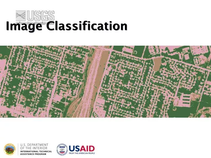
Image Classification. I mage C lassification The process of sorting pixels into a finite number of individual classes, or categories of data, based on their spectral response (the measured brightness of a pixel across the image bands, as reflected by the pixel’s spectral signature).

E N D
Image Classification The process of sorting pixels into a finite number of individual classes, or categories of data, based on their spectral response (the measured brightness of a pixel across the image bands, as reflected by the pixel’s spectral signature).
Image Classification The underlying assumption of image classification is that spectral response of a particular feature (i.e., land-cover class) will be relatively consistent throughout the image.
General Approaches to Image Classification Unsupervised Supervised
Unsupervised Classification • Unsupervised classification (a.k.a., “clustering”) identifies groups of pixels that exhibit a similar spectral response • These spectral classes are then assigned “meaning” by the analyst (e.g., assigned to land-cover categories)
Supervised Classification Supervised classification uses image pixels representing regions of known, homogenous surface composition -- training areas -- to classify unknown pixels.
Unsupervised vs. Supervised Classification Unsupervised: bulk of analyst’s work comes after the classification process Supervised: bulk of analyst’s work comes before the classification process
Advantages and Disadvantages of Unsupervised Classification? • Advantages • No prior knowledge of the image area is required • Human error is minimized • Unique spectral classes are produced • Relatively fast and easy to perform
Disadvantages of Unsupervised Classification • Spectral classes do not represent features on the ground • Does not consider spatial relationships in the data • Can be very time consuming to interpret spectral classes • Spectral properties vary over time, across images
Process of Unsupervised Classification Determine a general classification scheme Assign pixels to spectral classes (ISODATA) Assign spectral classes to informational classes
Process of Unsupervised Classification • Determine a general classification scheme • Depends upon the purpose of the classification • With unsupervised classification, the scheme does not need to be very specific • Assign pixels to spectral classes (ISODATA) • Assign spectral classes to informational classes
Process of Unsupervised Classification • Determine a general classification scheme • Assign pixels to spectral classes (ISODATA) • Group pixels into groups of similar values based on pixel value relationships in multi-dimensional feature space (clustering) • Iterative ISODATA technique is the most common • Assign spectral classes to informational classes
Feature Space • Multi-dimensional relationship of the pixel values of multiple image bands across the radiometric range of the image • Allows software to examine the statistical relationship between image bands
Feature Space Plot • Feature space images represent two-dimensional plots of pixel values in two image bands (with 8-bit data, in a 255 by 255 feature space) • The greater the frequency of unique pairs of values, the brighter the feature space • Distribution of pixels within the spectral space at bright locations, correspond with important land-cover types
ISODATA • “Iterative Self-Organizing Data Analysis Technique” • Uses “spectral distance” between image pixels in feature space to classify pixels into a specified number of unique spectral groups (or “clusters”)
ISODATA Parameters & Guidelines • Number of clusters: 10 to 15 per desired land cover class • Convergence threshold: percentage of pixels whose class values should not change between iterations; generally set to 95%
ISODATA Parameters & Guidelines • A convergence threshold of 95% indicates that processing will cease as soon as 95% or more of the pixels stay the same from one iteration to the next (or 5% or fewer pixels change) • Processing stops when the # of iterations or convergence threshold is reached (whichever comes first)
ISODATA Parameters & Guidelines • Maximum number of iterations: ideally, the convergence threshold should be reached • Should set “reasonable” parameters so that convergence is reached before iterations run out
ISODATA a) ISODATA initial distribution of five hypothetical mean vectors using +/- 1 standard deviation in both bands as beginning and ending points.
ISODATA b) In the first iteration, each candidate pixel is compared to each cluster mean and assigned to the cluster whose mean is closest
ISODATA c) During the second iteration, a new mean is calculated for each cluster based on the actual spectral locations of the pixels assigned to each cluster. After the new cluster mean vectors are selected, every pixel in the scene is assigned to one of the new clusters
ISODATA d) This split-merge-assign process continues until there is little change in class assignment between iterations (the threshold is reached) or the maximum number of iterations is reached
ISODATA • ISODATA iterations; pixels assigned to clusters with closest spectral mean; mean recalculated; pixels reassigned • Continues until maximum iterations or convergence threshold reached
Process of Unsupervised Classification • Determine a general classification scheme • Assign pixels to spectral classes (ISODATA) • Assign spectral classes to informational classes • Once the spectral clusters in the image are identified, the analyst must assign them to the “informational” classes of the classification scheme (i.e., land cover)
Example: Image to be Classified • Multiple clusters likely represent a single type of “feature” on the ground. • Someone needs to assign a landcover class to all of these clusters; can be difficult and time consuming.
General Approaches to Image Classification Unsupervised Supervised
Supervised Classification Supervised classification uses image pixels representing regions of known, homogenous surface composition -- training areas -- to classify unknown pixels.
Supervised Classification The underlying assumption is that spectral response of a particular feature (i.e., land-cover class) will be relatively consistent throughout the image.
Advantages • Generates informational classes representing features on the ground • Training areas are reusable (assuming they do not change; e.g. roads)
Disadvantages • Information classes may not match spectral classes • (e.g., a supervised classification of “forest” may mask the unique spectral properties of pine and oak stands that comprise that forest) • Homogeneity of information classes varies • Difficulty and cost of selecting training sites • Training areas may not encompass unique spectral classes
Process of Supervised Classification Determine a classification scheme Create training areas Generate training area signatures Evaluate and refine signatures Assign pixels to classes using a classifier (a.k.a., “decision rule”)
1 | Determine Classification Scheme • Depends upon the purpose of the classification • Make the scheme as specific as resources and available reference data allow • You can always generalize your classification scheme to make it less specific; making it more specific involves starting over
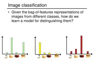
2 | Create Training Areas • Digitizing: drawing polygons around areas in the image • Seeding: “grows” areas based on spectral similarity to seed pixel • Using existing data: existing maps, field data (GPS, etc.), high-resolution imagery • Feature space image training areas
Digitizing Selecting ROIs Alfalfa Cotton Grass Fallow
Training Areas “Best Practices” • Number of pixels > 100 per class • Individual training sites should be between 10 to 40 pixels • Sites should be dispersed throughout the image • Uniform and homogeneous sites
3 | Generate Training Areas Signatures • Signatures represent the collective spectral properties of all the training areas defined for a particular class • the most important step in supervised classification
Types of Signatures • Parametric: signature that is based on statistical parameters (e.g., mean) of the pixels that are in the training area (normal distribution assumption) • Non-parametric: signature that is not based on statistics, but on discrete objects (polygons or rectangles) in a feature space image
Parametric Signatures e.g., mean of the pixels that are in the training area
Parametric Signatures e.g., mean of the pixels that are in the training area
Non-Parametric Signatures e.g., polygons in a feature space
4 |Evaluate and Refine Signatures • Attempt to reduce or eliminate overlapping, non-homogeneous, non-representative signatures • Signatures should be as “spectrally distinct” as possible
Some Signature Evaluation Methods • Ellipse evaluation (feature space) • Contingency matrices • Training area histograms • Signature plots
Contingency Matrix Contingency analysis produces a matrix showing the percentage of pixels that are classified correctly in a preliminary image classification of only the training areas • It assumes that most of the training area pixels should be assigned to their respective land-cover class • If a significant percentage of training pixels are classified as another land-cover, it indicates that the spectral signatures are not distinct enough to produce an accurate classification of the entire image