Download
1 / 17
170 likes | 266 Vues
UTLS Plume Alerts: observations from MODIS, MISR, TOMS, SeaWiFS Mike Fromm, Naval Research Lab, DC mike.fromm@nrl.navy.mil LANCE UWG Meeting, 16 November 2010.

E N D
UTLS Plume Alerts: observations from MODIS, MISR, TOMS, SeaWiFS Mike Fromm, Naval Research Lab, DC mike.fromm@nrl.navy.mil LANCE UWG Meeting, 16 November 2010
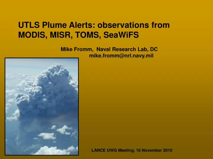
PyroCumulonimbus (pyroCb): 17 August 2003 Conibear Lake fire Northeast Alberta, near Fort Smith, NWT * Background: pre-LANCE example * Satellite-image highlights and challenges * LANCE added value
Here’s what “caught my eye”: TOMS Aerosol Index (AI): Top 4 of All Time Level 3 AI=18.8 Here! AI factors: 1. single scatter albedo 2. Optical depth 3. Plume altitude Extremely large AI values uniquely identify deep (e.g. UT/LS) AND optically thick plumes.
Aqua MODIS True Color 18 Aug 2003 1820 UTC (~2 hrs after TOMS) -90° -80° TOMS AI max 60°N How deep is this plume? Where did it come from?!
Sniffing out the “Smoking Gun:” Launch back trajectories at several altitudes, from AI max to prior afternoon. 10 km 12 km 14 km
Proof in living color: smoke in, on, and/or above anvil. SeaWiFS 17 August 2003 2113 UTC N Thanks to Norman Kuring, NASA GSFC!
By 11 am local, pyro-convection was bubbling. MISR multi-angle flyover 60º forward - 60º backward Time interval: 19:06 - 19:11 UTC
Satellite-image highlights and puzzles ! Brown, cold anvil ! Hot spot spread
AQUA MODIS 3.7 um Tb 19:15 UTC 17 Aug 2003 (true-color view below) Hand-drawn red outline encloses the hottest (black) pixels
AQUA MODIS 3.7 um Tb 20:55 UTC 17 Aug 2003 (true-color view below) 100 min. later Solid red outline copied from 19:15 image. Dotted red line shows change at 20:55 Fire rate of spread can be estimated
AQUA MODIS 11 um Tb 19:15 UTC 17 Aug 2003 Here is the IR view, showing the rapid blowup. In 100 min., we go from small pyroCu to…
AQUA MODIS 11 um Tb 20:55 UTC 17 Aug 2003 …two mature Cb pulses. Eastern anvil is now detached from the fire.
Plume Alerts in the LANCE Era * Forward Alerts: * Fire hot spots * volcano locations/hot spots * cloud brightness temperature * Backward alerts: * OMI AI, SO2 * AIRS CO, * MODIS cloud properties * CALIPSO VFM * LANCE requirements: 3 hr OK, Non-NASA data sets.