Download
1 / 21
260 likes | 579 Vues
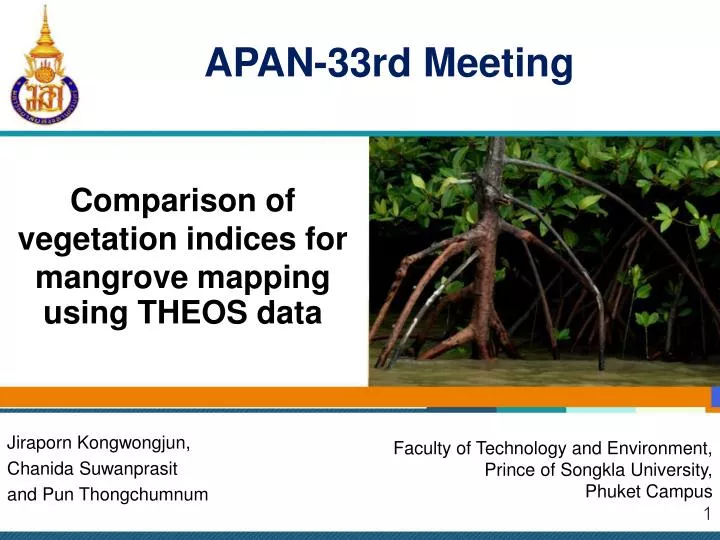
APAN-33rd Meeting. Comparison of vegetation indices for mangrove mapping using THEOS data. Jiraporn Kongwongjun, Chanida Suwanprasit and Pun Thongchumnum. Faculty of Technology and Environment, Prince of Songkla University, Phuket Campus. Outline. Introduction Objectives Study area

E N D
APAN-33rd Meeting Comparison of vegetation indices for mangrove mapping using THEOS data Jiraporn Kongwongjun, Chanida Suwanprasit and Pun Thongchumnum Faculty of Technology and Environment, Prince of Songkla University, Phuket Campus
Outline • Introduction • Objectives • Study area • Methodology • Result • Conclusion • Acknowledgement
The importance of mangroves Mangrove forests are useful as fishing areas, wildlife reserves, for recreation, human habitation, aquaculture and natural ecosystem. 1 2 3 4 5 6
Mangrove vegetations (a) Rhizophora mucronata Poir I (b) Rhizophora apiculata Blume (c) Sonneratia ovata Backer (Department of marine and coastal resource, 2011) (e) Rhizophora Bruguiera s. (d) Rhizophora Ceriops Decandra 1 2 3 4 5 6
Vegetation indices • The remote sensing is applicable for mangrove mapping. • The vegetation indices (VIs) in forest areas have been widely used and provide accurate classification. • Different VIs is suitable for different vegetation cover. 1 2 3 4 5 6
Objectives • To classify mangrove and non-mangrove areas. • To find out a suitable vegetation index for identifying mangrove area. 1 2 3 4 5 6
Study area Pa Khlok sub-district, Phuket, Thailand 1 2 3 4 5 6
Study area source: www.technicchan.ac.th, 2011 source: http://cccmkc.edu.hk 1 2 3 4 5 6
Methodology Input THEOS data Pre-Image Processing Visual Interpretation Image classification • 5 VIs • NDVI • SR • SAVI • PVI • TVI Post classification unsupervised supervised Compare Image K-mean Output mapping data Training ROI Test 1 2 3 4 5 6
THEOS Satellite (Pitan, 2008) 1 2 3 4 5 6
THEOS Spectral bands Band1: Blue 0.45 -0.52 µm Band2: Green 0.53 – 0.60 µm Band3: Red 0.62 – 0.69 µm Band4: NIR 0.77 – 0.90 µm 1 2 3 4 5 6
Selection of ROIs 1 2 3 4 5 6
ROIs Table Training Sample ROI Test Sample ROI 1 2 3 4 5 6
5 Vegetation Indices 1 2 3 4 5 6
Vegetation Indices NDVI SR SAVI PVI TVI 1 2 3 4 5 6
Image Classification Supervised Unsupervised K-mean MLC MLC+NDVI MLC+SR MLC+SAVI MLC+PVI MLC+TVI Classification 2 classes : mangrove and non – mangrove areas Blue = Mangrove Yellow = Non-mangrove 1 2 3 4 5 6
Overall accuracy 1 2 3 4 5 6
Conclusion • NDVI, SR and SAVI are the best indices between mangrove and non-mangrove forests with 96.78% overall accuracy. • THEOS with 15 m resolution is appropriate for visual interpretation. However, spectral resolution of 4 bands seems to give limited vegetation classification. 1 2 3 4 5 6
Acknowledgement • Faculty of Technology and Environment, Prince of Songkla university, Phuketcampus, providing invaluable assistance during work • Geo-Informatics and Space Technology Development Agency organization (GISTDA) • UniNet • Adviser and co-adviser in particular to Dr.ChanidaSuwanprasit and Dr.PunThongchumnumwho give suggestion • and Dr.NaiyanaSrichai and my graduate friends for encouragement. 1 2 3 4 5 6
References • PitanSinghasneh (2011). " THEOS Satellite Data Service " <http://www.gisdevelopment.net/technology/rs/mwf09_theos.htm> ( 10 February 2012) • Cccmkc University (2011). "Mangrove in Phuket, Thailand" <http://cccmkc.edu.hk/~kei-kph/Mangrove/mangrove_page%201.htm> ( 10 February 2012) • Huete A. (1988). “A soil-adjusted vegetation index (SAVI).” Remote Sensing of Environment, 25 (3), 295-309. • Richardson A. J. and Wiegand C. L. (1977). “Distinguishing vegetation from soil background information(by gray mapping of Landsat MSS data” Photogrammetric Engineering and Remote Sensing., 43(12), 1541-1552. • Pearson, R. L. and Miller, L. D. (1972). “Remote mapping of standing crop biomass for estimation of the productivity of the shortgrass prairie, Pawnee National Grasslands, Colorado” Proceedings of the 8th International Symposium on Remote Sensing of the Environment II., 1355-1379. • Broge, N. H., & Leblanc, E. (2000). “Comparing prediction power and stability of broadband and hyperspectral vegetation indices for estimation of green leaf area index and canopy chlorophyll density”. Remote Sensing of Environment, 76, 156−172. • Department of marine and coastal resource. (2011). " Research Paper 14th Mangrove National Seminar" < http://issuu.com/mffthailand/docs/mangrove14th > ( 10 February 2012) 1 2 3 4 5 6
APAN-33rd Meeting THANK YOUFORYOUR ATTENTION Jiraporn Kongwongjun, Chanida Suwanprasit and Pun Thongchumnum Faculty of Technology and Environment, Prince of Songkla University, Phuket Campus