Download
1 / 16
160 likes | 256 Vues
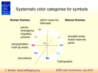
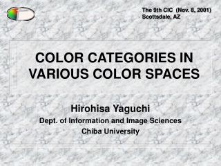
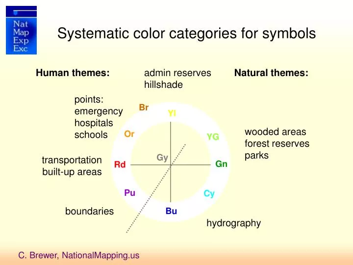
Systematic color categories for symbols. Human themes:. admin reserves hillshade. Natural themes:. points: emergency hospitals schools. Br. Yl. wooded areas forest reserves parks. Or. YG. Gy. transportation built-up areas. Gn. Rd. Pu. Cy. boundaries. Bu. hydrography.

E N D
Systematic color categories for symbols Human themes: admin reserves hillshade Natural themes: points: emergency hospitals schools Br Yl wooded areas forest reserves parks Or YG Gy transportation built-up areas Gn Rd Pu Cy boundaries Bu hydrography
Systematic color categories for symbols Human themes: admin reserves hillshade Natural themes: points: emergency hospitals schools Br Yl wooded areas forest reserves parks Or YG Gy transportation built-up areas Gn Rd Pu Cy boundaries Bu hydrography
Color contrasts Red roads vs brown contours hard to distinguish – use gray contours All colors lighter than black labels – few halos This is not a road map – do not use whole contrast range on road categories Leave contrast available for update and overlay of operational information magenta could be used for additions if no magenta symbols Contrasting outlines on point symbols separate from each other and background
Halos and casings • Dull greenish brown halo on contour labels • Slightly blue halo on hydro labels • Slightly beige casing on local roads • Slightly gray fill in road shields • Slightly gray drop shadow on populated place names • Other labels dark enough to read over content
Geoprocessing for map design Contour cracking for faster drawing Polygon-to-line for dashed lines Dissolve on attribute to join small segments (e.g., roads) Pair layers with version not symbolized for labels with different classes (e.g., flowlines, admin areas, populated places) Flowline upstream drainage area (UDA) calculated for stream tapering Smooth DEM firstto create generalized contours and hillshade for terrain
HydrographyMO 1:50K Tapered by symbolizing upstream drainage area (stream order or length not useful) Intermittent and perennial symbolized
Stream tapering Width (pts) RGB lighter 0.38 100,180,200 0.75 100,180,200 med blue 1.13 50,165,200 1.50 50,165,200 darker 1.88 0,150,200 2.25 0,150,200
Examples of international topo maps using stream tapering Viet Nam Japan Botswana Brazil
HydrographyMO 1:50K Tapered by symbolizing upstream drainage area (stream order or length not useful) Intermittent and perennial symbolized
Stream tapering details Perennial Flowlines
WV 1M ArcMap capture
Flowlines PerrenialFlowlines Intermittent Flowlines Flowline Labels 24K…
Waterbodies Inundation Area Wash Sand/Mud Flat Swamp/Marsh Lake/Pond Reservoir Intermittent Lake 24K…