Download
1 / 33
340 likes | 634 Vues
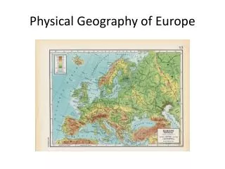
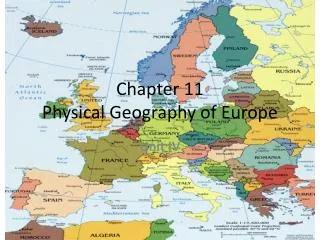
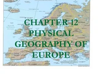
The physical geography of Europe. Chapter 11, Section 1: The Land. Standards and Objectives. Standards: Create and use maps, technology, imagery, and other geographical representations to extrapolate and interpret geographic data.

E N D
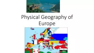
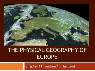
The physical geography of Europe Chapter 11, Section 1: The Land
Standards and Objectives Standards: • Create and use maps, technology, imagery, and other geographical representations to extrapolate and interpret geographic data. • Engage in informed and respectful deliberation and discussion of issues, events, and ideas. Objectives: At the end of this section, students will be able to: • Define terms related to the physical geography of Europe. • Use maps of Europe to identify, locate and compare regions, locations, places, movements, and physical features • Compare and contrast the land areas of Russia and Europe by writing a five paragraph essay. • Research and discuss current issues/events related to physical features of Russia
Class Work • Page 229: Questions 1, 2, 3, and 4 • Answers • fjord: long, steep-sided glacial valley now filled with water; polder: drained areas; peat: compacted vegetable matter composed of mosses • Interior, and along northern and southern edges • Peninsulas, irregular, islands, fjords • Iron and coal
Peninsulas and Islands • Scandinavian Peninsula • Norway: Last Ice Age glaciers scraped out huge areas along the coast that filled with water (fjords) and today make excellent, deep harbors • Sweden is the eastern half of the Scandinavian Peninsula
Peninsulas and Islands • Jutland Peninsula • Denmark • Western coast of sandy beaches • Marshes in Southwest due to tides of North Sea • Eastern coast is rolling hills
Peninsulas and Islands • The Iberian Peninsula • Spain and Portugal: large, semi-arid plateau • Plains along western and southern coasts; • Rugged Pyrenees Mountains run along border with France
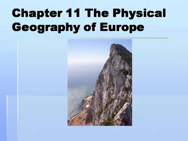
Peninsulas and Islands • Apennine Peninsula: Italy; Apennine Mountains run down center, • Northern part mostly plains; rugged coast with cliffs
Peninsulas and Islands • Balkan Peninsula: • Made up of many countries • Bosporus and the Dardanelles Straits connect the Mediterranean with the Black Sea • Highly mountainous and subject to earthquakes and volcanic activity
Map Work • Locate the following places and label them on your map. • Scandinavian Peninsula, Norway, Sweden • Jutland, Denmark, North Sea, Baltic Sea • Apennine Peninsula, Apennine Mountains, Mt. Vesuvius, Italy, Mediterranean Sea • Balkan Peninsula, Greece, Turkey, Albania, Bulgaria, Slovenia, Croatia, Bosnia, Serbia, Hungary, Romania, Dardanelles Strait, Bosporus
Bell Work: Vesuvius Shorts Number a blank page 11 and write the questions and answers on it. • Near what Italian city is Mt. Vesuvius located? • When was it’s last eruption? Though the volcano's last eruption was in 1944, it still represents a great danger to the cities that surround it, especially the busy metropolis of Naples.
Bell Work: Vesuvius Shorts 3. What plate is sub ducting under Italy? 4. How is the magma formed? Magma produced from the melting African plate creates the large, violently explosive volcanoes of the Italian Peninsula.
Bell Work: Vesuvius Shorts 5. How do we know the exact date and time of the eruption? The 79 AD eruption of Vesuvius is why volcanologists use "Plinian" to describe large volcanic eruption clouds. Pliny the Younger, a Roman historian who witnessed the 79 AD eruption, wrote the oldest surviving description of the tall, tree-shaped cloud that rose above the volcano.
Peninsulas and Islands Video and Video Questions: Pompeii: The Last Day
Primary Source: Use page 11 Bell Work: Select five items from the quote below that match the film and be prepared to defend them. "On 24 August, in the early afternoon, my mother drew [my uncle's] attention to a cloud of unusual size and appearance. its general appearance can be best expressed as being like an umbrella pine, for it rose to a great height on a sort of trunk and then split off into branches, I imagine because it was thrust upwards by the first blast and then left unsupported as the pressure subsided, or else it was borne down by its own weight so that it spread out and gradually dispersed. Sometimes it looked white, sometimes blotched and dirty, according to the amount of soil and ashes it carried with it."
Peninsulas and Islands • Iceland: located near Arctic Circle in North Atlantic Ocean • on the mid-Atlantic Ridge, it has volcanoes, geysers, and hot springs next to glaciers
Peninsulas and Islands • British Isles • Two islands: Great Britain and Ireland • Rugged coastlines with rocky cliffs • Great Britain is mountainous in the north and flatter in the south • Ireland has a mild, cool climate and is very green, so called the Emerald Isle
Peninsulas and Islands • Mediterranean Islands • Islands off coast of Italy—Corsica, Sardinia, Sicily and Malta; rugged, mountainous with warm climates that attract tourism • Greek Islands are mainly hills and fertile valleys Locate the following places on your maps: Iceland, Great Britain, Ireland, Corsica, Sardinia, Sicily, Malta, Aegean Sea, Ionian Sea
Peninsulas and Islands Video Clip: How the Earth Was Made: Iceland
Peninsulas and Islands • Complete questions 1-4 on page 225. • How does the Rhine River contribute to Germany’s economy? • What mountain chain extends through the Italian peninsula? • What body of water separates the United Kingdom from Denmark? • What city is the capital of Portugal? Answers Transport goods Apennines North Sea Lisbon
Mountains and Plains • The Pennine Range forms the backbone of the Great Britain; oldest rocks in world • The Scottish Highlands are rocky, barren and include low mountains and high plateaus • Scottish Highlands
Mountains and Plains • Alpine Mountain system runs from the Alps to the Carpathians; the Alps are the largest, touching four countries—France, Switzerland, Italy, and Austria
Mountains and Plains • Locate the following places on your map: Pennine Range, Scottish Highlands, Alps, Carpathians, English Channel
Mountains and Plains Europe is plains interrupted by Mountains • The North European Plain stretches from France to the Urals (gray) • Mostly rolling land with low hills and mountains • Netherlands reclaimed some of the land from the sea by pumping water; this land is referred to as polders
Mountains and Plains • The Hungarian Basin is a treeless stretch of land known for horse racing and agriculture Label the North European Plains and the Hungarian Basin on your map
Rivers and Lakes • The Rhine River • Most important river in western Europe • Connects many industrial cities to the port of Rotterdam on North Sea
Rivers and Lakes • The Danube River • Most important waterway in eastern Europe • Carries millions of tons of cargo to the Black Sea
Rivers and Lakes • Lakes • Sweden and Finland are covered with lakes • Lake Geneva reflects the beauty of the Alps and lies on the border between France and Switzerland; half of the lake is controlled by France and half by the Swiss
Rivers and Lakes • Locate the Rhine River, the Danube River, and Lake Geneva on your map Danube River Cruise Tour—HD
Natural Resources • Europe has large amounts of iron and coal, which are requirements for an industrial society Discuss and answer the questions based on the maps. Iron Ore Coal, 2005
Natural Resources • Other Mineral Resources • Many of Europe’s industrial and transportation centers developed around mineral deposits • Bauxite—ore used to make aluminum • Potash—used in fertilizer • Copper, lead, zinc, uranium, gold, silver Great Copper Mountain, Sweden
Natural Resources • Other Energy Sources • In past times, many Europeans relied on the burning of peat for energy, but now they use oil, coal, gas, nuclear and hydroelectric • The world’s first tidal power plant started in France in the 1966 Read the article on modern tidal power and answer the questions.
Natural Resources • Article Questions and Answers • If the project costs 40 million Euros to build and will serve 4000 homes, how much per home will the project cost? • In what ways will this French project dwarf all others? • What are the advantages of tidal energy power over other reusable sources?
Capstone Project • Compare and contrast the lands of Europe with those of Russia • Write a five paragraph essay • The thesis should include any three of the following: mountains, plains, rivers, lakes, seas, natural resources • The three body paragraphs should include at least three facts about the Russian topic and three facts about the European topic • The concluding paragraph should sum up the essay