Download

1 / 42
700 likes | 1.46k Vues
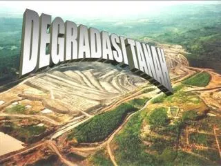
KETAHANAN SUMBERDAYA ALAM DAN PANGAN smno.psdl.ppsub. DEGRADASI LAHAN. DEGRADASI LAHAN PERTANIAN. DEGRADASI LAHAN.

E N D
KETAHANAN SUMBERDAYA ALAM DAN PANGAN smno.psdl.ppsub DEGRADASI LAHAN
DEGRADASI LAHAN Degradasilahanmerupakanprosesmenurunnyakualitasdankuantitassuatulahan yang meliputiaspekfisikatanah, kimiatanah, biologitanah, padasuatubidanglahantertentu. Dalampraktekbudidayapertaniansendiriseringakanmenimbulkandampakpadadegradasilahan. Duafaktorpentingdalamusahapertanian yang potensialmenimbulkandampakpadasumberdayalahan, yaitutanamandanmanusia (sosiokultural) yang menjalankanpertanian. Faktor AKTIVITAS manusiadapatmemberikandampakpositipataunegatippadasuatulahan, tergantungpadaaktivitaspengelolaanpertanian yang dilakukan. Apabiladalammenjalankanpertaniannyabenarmakaakanberdampakpositip, namunapabilacaramenjalankanpertaniannyasalahmakaakanberdampaknegatif. Kegiatanbudidayapertanian yang menimbulkandampakantara lain meliputikegiatanpengolahantanah, penggunaansaranaproduksi yang tidakramahlingkungan (pupukdaninsektisida) sertasistembudidayatermasukpolatanam yang merekagunakan. Tigafaktorpenyebabdegradasitanahakibatcampurtanganmanusiasecaralangsung, yaitu : pertanianintensif, pembukaantambang, deforestasi. Faktor-faktortersebutdi Indonesia padaumumnyaterjadisecarasimultan, berikutadalahpembahasandariketigadegradasipadatigabidang. Diunduhdari: http://andikks.blogspot.com/2012/06/degradasi-lahan_05.html……… 24/12/2012
DEGRADASI LAHAN • DEGRADASI LAHAN PERTANIAN • Aktivitasbudidayapertaniandapatmenyebabkandampaknegatifpadasumberdayalahan. • Erosidanpencemarantanahterjadiakibatbudidayapertanian yang melampauidayadukungtanah. Penggunaanbahan-bahanagrokimia yang berlebihandapatmencemarilingkungandanmengganggukelestariankualitastanah. Cara-carabudidayapertanian yang tidakmengindahkankaidahkaidahkonservasilahanmenyebabkankualitaslahanmenurunsejalandenganhilangnyalapisantanahsuburakibaterosidanpencucianhara. • Kegiatanpembangunan yang berpotensimenimbulkandampakterhadapdegradasilahanantara lain kegiatandeforesterisasi, industri, pertambangan, perumahan, dankegiatanpertaniansendiri. Apabilakegiatantersebuttidakdikeloladenganbaik, makaakanmengakibatkanterjadinyadegradasilahanpertanian yang mengancamkeberlanjutanuasahatanidanketahananpangan. Olehkarenanya, dalamkegiatanpembangunanhendaknyaharusdipikirkankeberlanjutannyadimasamendatang (sustainabilitas). • Praktekbudidayapertanianseringmengakibatkandegradasilahan. Kegiatanbudidayapertanian yang menimbulkandampaknegatifantara lain meliputikegiatanpengolahantanah, penggunaansaranaproduksi yang tidakramahlingkungan (pupukdanpestisida), sertasistembudidayatermasukpolatanam yang tidaktepat. Diunduhdari: http://andikks.blogspot.com/2012/06/degradasi-lahan_05.html……… 24/12/2012
DEGRADASI LAHAN • Barrow (1991) merincifaktor-faktorutamapenyebabdegradasilahan : • 1) Bahayaalami • 2) Perubahanjumlahpopulasimanusia • 3) Marjinalisasitanah • 4) Kemiskinan • 5) Status kepemilikantanah • 6) Ketidakstabilanpolitikdanmasalahadministrasi • 7) Kondisisosialekonomi • 8) Masalahkesehatan • 9) Praktekpertanian yang tidaktepat, dan • 10) Aktifitaspertambangandanindustri. • Degradasilahanadatigaaspek, yaitu : aspekfisik. kimiadanbiologi. • Degradasifisikterdiridaripemadatan, pengerakan, ketidakseimbangan air, terhalangnyaaerasi, aliranpermukaan, danerosi. • Degradasikimiawiterdiridariasidifikasi, pengurasanunsurhara, pencucian, ketidakseimbanganunsurharadankeracunan, salinisasi, danalkalinisasi. • Degradasibiologismeliputipenurunankarbonorganiktanah, penurunankeanekaragamanhayatitanah, danpenurunankarbonbiomas. Diunduhdari: http://pinterdw.blogspot.com/2012/06/penyebab-degradasi-lahan.html……… 24/12/2012
DEGRADASI LAHAN TYPES OF SOIL DEGRADATION Soil degradation is any type of problem that removes soil in an area or makes high-quality soil become poor. Careless agricultural practices, pollution and deforestation cause lots of soil degradation in the world. Several types of soil degradation exist and are a threat to natural forests and planted crops. Read more: Types of Soil Degradation | eHow.comhttp://www.ehow.com/list_6523052_types-soil-degradation.html#ixzz2FuczEfSE SOIL EROSION Erosion occurs when the topsoil that many plants need to grow gets blown or washed away. While some erosion is natural, the humans often remove plants that cover soil and, therefore, speed up erosion. Since topsoil takes so long to build back up through natural processes, erosion damage is almost irreversible. NUTRIENT LOSS Nutrient loss often occurs in conjunction with salinization. The nutrient loss occurs through a variety of mechanisms, including leaching, erosion, runoff, crop uptake and denitrification. The crops uptake too many soil nutrients that farmers do not always replace. Deforestation and careless agricultural processes lead to soil degradation in the form of nutrient loss. After soil becomes nutrient-poor, crops and naturally occurring plants have a hard time growing in the area. Diunduhdari: http://www.ehow.com/list_6523052_types-soil-degradation.html……… 24/12/2012
DEGRADASI LAHAN SOIL DEGRADATION When plants (trees & shrubs) are cleared from a site, soil is exposed to sunlight and the eroding effects of wind and water. Soil aeration is increased and the rate of weathering increases.Apart from erosion, the proportion of organic matter in the soil gradually decreases, through the action of microbes in the soil which use it as a source of energy ‑ unless the new land use provides some replacement. TYPES OF SOIL DEGRADATIONA number of major soil related problems occur in Australia these include: Kehilangankesuburantanah Erosi Tanah Salinitas Pemadatan Tanah Pengasaman Tanah Pencemarantanaholehbahankimiaberbahaya. Diunduhdari: http://www.acsgarden.com/articles/other-gardening/soil-degradation.aspx……… 24/12/2012
HILANGNYA KESUBURAN TANAH KESUBURAN TANAHLand use, human nutrition and the carbon cycle form an intricate set of relationships. Healthy plants use carbon dioxide, give off oxygen and increase soil organic matter (OM), thereby enhancing soil fertility. Practices that increase organic matter can increase soil fertility while decreasing greenhouse gas emissions. Diunduhdari: http://www.fertilizer101.org/science/?seq=7 ……… 24/12/2012
HILANGNYA KESUBURAN TANAH BASIC PLANT NUTRIENT CYCLE The basic nutrient cycle usually describes the outstanding role of soil organic matter. Cycling of many plant nutrients, especially N, P, S, and micronutrients, are similar to the Carbon Cycle. Plant residues, grain green manure, farmyard manure and other substances are returned to the soil. This organic matter pool of carbon compounds serve as food for bacteria, fungi, and other decomposers. As organic matter is decomposed to simpler compounds, plant nutrients are released in available forms for root uptake and the cycle begins again. Plant-available macronutrients such as N, P, K, Ca, Mg, S and micronutrients are also released when soil minerals dissolve. Diunduhdari: http://www.tankonyvtar.hu/hu/tartalom/tamop425/0010_1A_Book_angol_02_tapanyaggazdalkodas/ch05.html ……… 24/12/2012
HILANGNYA KESUBURAN TANAH POTENTIAL FOR N LOSSES Greater losses occur when soils enter the spring season with recharged subsoil moisture, when more N is in the nitrate form, and when soils are warm. Deciding if losses are substantial enough to warrant supplemental N application must therefore take into consideration the following factors: (1) amount of nitrate present, which is affected by time of N application, form of N applied, rate applied, and use of a nitrification inhibitor; (2) when and the length of time soils are saturated; (3) subsoil recharge, leaching rate, and drainage--water amount moved through the soil; and (4) loss of crop yield potential from water damage. Diunduhdari: http://www.ipm.iastate.edu/ipm/icm/2007/5-14/nitrogenloss.html ……… 24/12/2012
HILANGNYA KESUBURAN TANAH Integrated plant nutrient components in the Nepalese farming system An integrated nutrient model developed quite some time ago as shown below was a successful programme but it has not been popularized or has not been well adopted by large number of farmers. There should be a follow up study to see the impact on soil fertility management and to look on how best we can promote to wider areas. Diunduhdari: http://www.fao.org/docrep/010/ag120e/AG120E10.htm ……… 24/12/2012
HILANGNYA KESUBURAN TANAH KEHILANGAN HARA DARI TANAH There are several losses from soil nutrient pools caused by either unfavorable soil conditions or improper use of fertilizers. The main characteristics of these losses are the following: Losses will result in a decrease in the amounts of plant available soil nutrients Nutrient losses occur by: Releases from the soil - leaving the soil-plant system Transformation of soil nutrients into non-available forms (i.e. precipitation, chemical reactions resulting insoluble forms etc.) = „internal losses” PELEPASAN HARA DARI TANAH Crop removal by yields Erosion losses – nutrients in soil particles removed from soil by water Runoff – loss of dissolved nutrients moving across the soil profile Leaching– moving dissolved nutrient forms downward into the groundwater Gaseous losses to the atmosphere by volatilization and denitrification. Under various cropping systems, both internal and external losses of nutrients from soils may be rather diverse. „INTERNAL LOSSES” Transformation of soil nutrients into non-available forms (i.e. precipitation, chemical reactions resulting insoluble forms etc.) Transformation into insoluble forms – typical for P Strong fixation in interlayer sites of clay minerals – ammonium and K+ ions These forms do not leave the soil = therefore referred as „internal losses” http://www.tankonyvtar.hu/hu/tartalom/tamop425/0010_1A_Book_angol_02_tapanyaggazdalkodas/ch05.html
HILANGNYA KESUBURAN TANAH What happens if we lose soil fertility, we will eventually cease to exist as soil is alive and we require soil for almost all of the food that we grow today around the world. The healthy soil contains: It has sufficient concentrations of nitrogen, phosphorous, and potash (potassium) to support plant life. It also has sufficient levels of the trace minerals needed for plant nutrition, including boron, chlorine, cobalt, copper, iron, manganese, magnesium, molybdenum, sulfur, and zinc. Diunduhdari: http://www.examiner.com/article/permaculture-from-a-to-z-fertility-of-the-soil ……… 24/12/2012
EROSI TANAH Soil erosion is a natural process characterized by the transport or displacement of particles (sediment) that are detached by rainfall, flowing water, or wind. Soil erosion can be caused by the improper use of lands for cultivation or grazing and by deforestation. The types of soil erosion associated with agricultural activities are : Splash erosion, which occurs when rain hits exposed soils. Sheet and rill erosion, which mainly moves soil particles from the surface or plough layer of the soil. Surface sediments typically contain higher pollution potential due to richer nutrient content, the presence of chemicals from past fertilizer and pesticide applications, and natural biological activities. Rill and gully erosion, severe erosion in which trenches are cut to a depth greater than 1 foot. Generally, trenches too deep to be crossed by farm equipment are considered gullies (USEPA, 1994). Stream and channel erosion, which occurs due to increased rates and volumes of runoff from agricultural land uses flowing through a stream or channel. Diunduhdari: http://www.cep.unep.org/pubs/Techreports/tr41en/section3.html……… 24/12/2012
EROSI TANAH Effect on soil erosion Slope angle and length affects runoff generated when rain falls to the surface. Examine the diagram below showing the relationship between hill slope position, runoff, and erosion. The amount of water on a particular hill slope segment is dependent on what falls from precipitation and what runs into it from an upslope hill slope segment. The hill slope has been divided into several segments and the amount of precipitation falling on each segment is the same. As water runs down slope, the water that has accumulated in segment A runs off adding to what falls into segment B by precipitation. The water in B runs into C, and C into D, and so on. The amount of water increases in the down slope direction as water is contributed of water from upslope segments. The velocity of the water increases as well as it moves towards the base of the slope. As a result, the amount and velocity of water, and hence rate of erosion increases as you near the base of the slope. Diunduhdari: http://www.earthonlinemedia.com/ebooks/tpe_3e/soil_systems/soil__development_soil_forming_factors.html……… 24/12/2012
EROSI TANAH PENGENDALIAN EROSI Soil erosion occurs naturally when rain falls. Runoff flows to the lowest point of the landscape. The velocity depends on the characteristics of the soils, the slope of the land and the vegetative cover. Erosion can be a serious environmental problem when the land is disturbed by development, agriculture, or forestry. Surfaces like roads, roofs, driveways and hard-packed soils will not absorb water, and the runoff increases. Expanses of pavement like parking lots reduce the chances for ground water recharge. Exposed soils are lost and the land becomes less productive. Fertilizers and pesticides that may have been applied wash away, too, causing water quality problems for people living downstream. Diunduhdari: http://www.ecy.wa.gov/programs/wq/wqguide/erode.html……… 24/12/2012
EROSI TANAH EROSION EFFECTS ON SOIL WATER STORAGE, PLANT WATER UPTAKE, AND CORN GROWTH B. J. Andraski and B. Lowery SSSAJ. 1992. Vol. 56 No. 6, p. 1911-1919 Levels of past erosion were based on depth to red clay (2Bt horizon): slight, 0.95 m; moderate, 0.74 m; and severe, 0.45 m. The total quantity of plant-extractable water that could be stored in the upper 1 m of slightly eroded soil (181 mm) was 7% more than that for moderately eroded soil (169 mm) and 14% more than that for severely eroded soil (159 mm). For all erosion levels, water retained in the 0.5- to 1.0-m soil depth was utilized by corn. Erosion level had no negative effect on early-season plant growth. As plant-extractable water decreased to <55 to 60% of total, evapotranspiration (ET) and vegetative-growth rates decreased as erosion level increased. The greatest differences in ET rates among erosion levels were observed during a 35-d period in the drought year of 1988 when rates averaged 3.7 mm d−1 for slight erosion, 2.6 mm d−1 for moderate erosion, and 2.2 mm d−1 for severe erosion. For the 3 yr in which plant water stress was observed, maximum plant heights for the slight erosion level averaged 7% more than those for moderate erosion and 13% more than those for severe erosion. Although the soil's capacity to store and supply water decreased as erosion increased, the observed effects of erosion level on grain and stover yields, grain-yield components, and harvest populations typically were not significant. Diunduhdari: ……… 24/12/2012
EROSI TANAH . CROPPING AND TILLAGE SYSTEMS EFFECTS ON SOIL EROSION UNDER CLIMATE CHANGE IN OKLAHOMA X.-C.(John) Zhang SSSAJ. 2012. Vol. 76 No. 5, p. 1789-1797 Soil erosion under future climate change is very likely to increase because of increases in occurrence of heavy storms. The objective of this study is to quantify the effects of common cropping and tillage systems on soil erosion and surface runoff during 2010 to 2039 in central Oklahoma. A combination of 18 cropping and tillage systems is evaluated using the Water Erosion Prediction Project (WEPP) model for 12 climate change scenarios projected by four global climate models (GCMs) under three emissions scenarios. Tillage systems include conventional, reduced, delayedno tillage. Cropping systems include continuous monocultures of winter wheat, soybean, sorghumcotton and double crops of wheat and soybeans. Compared with the present climate, overall t tests show that the future mean precipitation will decrease by some 6% (>98.5% probability), daily precipitation variance increase by 12% (>99%), and mean temperature increase by 1.36°C (>99%). Despite the projected precipitation declines, the overall averaged runoff and soil loss will increase by 19.5 and 43.5% because of increased occurrence of large storms. Soil erosion is positively related to the degree of tillage disturbances in all cropping systems. Compared with the conventional till, reduced, delayedno tillage substantially reduce soil erosion, showing that adoption of conservation tillage will be effective in controlling soil erosion in the next 30 yr. Cropping systems decrease runoff and soil loss from continuous cotton to soybean to sorghum to wheat in all tillage systems under climate change, indicating a preference of winter wheat for controlling runoff and soil loss in the region. Diunduhdari: https://www.soils.org/publications/sssaj/abstracts/76/5/1789……… 24/12/2012
DEGRADASI LAHAN .SOIL EROSION EFFECTS ON CORN YIELDS ASSESSED BY POTENTIAL YIELD INDEX MODEL E. M. Craft , R. M. Cruse and G. A. Miller SSSAJ. 1992. Vol. 56 No. 3, p. 878-883 Soil erosion alters crop production via alteration of the soil chemical and physical environment. The objectives of this study were to: (i) develop a Potential Yield Index (PYI) model to index soil productivity based on simulated root growth, soil properties, and potential nutrient and water uptake of corn (Zeamays L.) through a growing season, (ii) utilize the PYI to estimate erosion effects on soil productivity by simulating the removal of 15 and 30 cm of soil, and (iii) simulate the impact of fertilizer additions to the eroded soil on the PYI. The PYI model independently estimates P, K, and water (W) uptake by corn. From these estimates, three separate yield indexes (PYIP, PYIK, and PYIW) are calculated. The lowest yield index is identified as the PYI for a given soil. The predicted PYIs for 45 soils in Iowa compared well to the 1984 10-yr average corn yield (R2 = 0.83) and corn suitability rating (R2 = 0.73) for each soil. Changes in the PYI were predicted for 15 and 30 cm of simulated erosion. After 15-cm soil loss, the PYI for all soils decreased, with all but three soils remaining within 15% of the uneroded PYI. The PYI decreased further after 30-cm soil loss, with only 12 soils remaining within 15% of the uneroded PYI. Fertilizer additions to the plow layer of the eroded soils were then simulated. The PYI returned to within 5% of the uneroded PYI for 38 soils with 15-cm soil loss and for 27 soils with 30-cm soil loss. The PYI indicated that the soil factor that most limited plant yield changed with the soil, amount of soil loss, and plow-layer soil fertility status. Diunduhdari: https://www.agronomy.org/publications/sssaj/abstracts/56/3/SS0560030878 ……… 24/12/2012
EROSI TANAH PERKIRAAN TINGKAT EROSI TANAH DI SUB DAS BESAI, LAMPUNG BARAT AsepMulyono Jurnal Riset Geologi dan Pertambangan, Vol 19, No 1 (2009) Tingkat erositanahdi sub DAS Besaitelahdiperkirakansebagaidasarkuantitatifdalammerekomendasikanupayamempertahankan, memulihkan, meningkatkankesuburandanfungsitanahsebagaipengaturtata air. Perkiraantingkaterositanahdilakukandenganmetoda RUSLE yang dilakukansecaraspasialdenganmenggunakanperangkatlunakSisteminformasigeografis (SIG). Erosivitas, erodibilitas, kemiringanlereng, panjanglereng, sistempenanamandanfaktorkonservasimerupakan 6 parameter data yang dimasukandalampendekatan RUSLE. Tingkat konversilahan, khususnyahutanlindungmenjadilahanpertaniandanperkebunan, sangatpesatterjadidi Sub DAS Besai. Sub DAS Besai yang terletakdiwilayahKecamatanSumber Jaya, Kabupaten Lampung Barat merupakansalahsatubagianhulu DAS TulangBawang Lampung. Selamarentangwaktu 30 tahun (1970 – 2000) telahterjadipenurunantutupanlahanhutansebesar 48 %. Perubahanterjadisebagaiakibattingginyaaktivitasmasyarakatdalamusahatani kopi monokulturdantanamansemusim. Hasilstudimenunjukkan 23.62% wilayahpenelitiandikategorikandalamtingkaterositanah yang normal, tingkatringanseluas 42.98%, tingkatmoderatseluas 14.57%, tingkatberatseluas 15.38% dansangatberatseluas 3.45%. Seluas 45% wilayahdengantutupanlahanperkebunan kopi mengalamitingkaterosidalamkategoriringansampaisangatberatpadasemuarentangkelerengandanjenistanah. Perkebunan kopi sistemmonokulturmengakibatkanlapisantanahsangatmudahtergerusolehadanyaaliranpermukaandikarenakantidakadanyatutupantanahdibawahkanopitanaman kopi tersebut. Diunduhdari: http://www.geotek.lipi.go.id/riset/index.php/jurnal/article/view/28 ……… 25/12/2012
EROSI TANAH EVALUASI SEDIMENT YIELD DI DAERAH ALIRAN SUNGAI CISANGGARUNG BAGIAN HULU DALAM MEMPERKIRAKAN SISA UMUR WADUK DARMA Muhammad Nursa’ban. HasilPenelitianDosenmudatahun 2006, DosenJurusanPendidikanGeografi UNY. Hasilpenelitianmenunjukanbahwatingkaterositanahpermukaanyaitu 31.558,74 ton/tahun, atau rata-rata 573,795 ton/ha/tahun, erosi total 39.448,43 ton/tahunatau 717,244 ton/ha/tahundanerositanah yang diperbolehkanyaitu 686,033 ton/tahunatausekitar 12,473 ton/ha/tahun. Data-data tersebutmenunjukkanbahwatingkaterosipermukaanmaupunerosi total berlangsungcukuptinggidibandingkandenganbesarerosi yang diperbolehkan. Sediment Yield tahunandiWadukDarmayaitu 32.996,419 ton/tahunatau 14.873,660 m3. WadukDarmatidakdapatberfungsilagiyaitupadasaatmencapaiumur ± 84,25 tahun. Tahun 2006 WadukDarmatelahberoperasiselama 36 tahunsehinggasisaumurWadukDarmasampaiterpenuhinyatampunganmatiolehsedimenyaitu ± 48,25 tahunatautampunganmatiakanterisipenuhyaitupadatahun ± 2054. Diunduhdari: staff.uny.ac.id/..../artikel_sediment%20yield_sainte... ……… 25/12/2012
EROSI TANAH PREDIKSI BEBAN NUTRIEN DAN SEDIMEN DAS SUMPUR DANAU SINGKARAK MENGGUNAKAN MODEL AGNPS TuahtaTarigandanIwanRidwansyah. LIMNOTEK, 2005, Vol, XII, No, 2, p. 34-40 AGNPS merupakansebuah program model untukmensimulasikankualitas air dansedimendarisuatu catchment yang didominasilahanpertanian. Model inidikombinasikandenganperangkat program GIS untukmemperkirakankemungkinanpenambahanfosporke DAS Sumpur, Paket Program GIS (ArcView 3.1, 3D Analyst, Spatial Analyst) digunakanuntukmempersiapkan input data model danprosespenempatandarihasilsimulasi. Perkiraandari loading nutrient dari Sungai Sumpur yang masukkeDanauSingkarakmemperlihatkannilai 1.875 ton tahun-1 sedimen, 52,5 ton tahun-1 Total N dan 37,5 ton tahun-1 Total P dan 195 ton tahun-1 COD. Diunduhdari: www.limnologi.lipi.go.id/.../makalah.php?... ……… 25/12/2012
EROSI TANAH MODIFIKASI FAKTOR C-USLE DALAM MODEL ANSWERS UNTUK MEMPREDIKSI EROSI DI DAERAH TROPIKA BASAH (STUDI KASUS: DAS NOPU HULU, SULAWESI TENGAH) Y. Hidayat, N. Sinukaban, H. Pawitan, dan K. Murtilaksono Jurnal Tanah dan Iklim. Vol.26 No.4 Th. 2004 Penelitiandilakukanuntuk : a) mendefinisikannilaifaktorpengelolaantanamansebagai parameter input model ANSWERS, b) membangun model ANSWERS dalamPCRasteruntukmensimulasikanperubahanpenggunaanlahandanpenerapanteknikkonservasitanahdan air, dan c) mengkajidampakkonversihutanterhadapaliranpermukaan, erosidankehilanganhara. Aliranpermukaandanerosihariandiukurpadalahanhutan primer, hutansekunder, lahanterbuka, jagung, kakaomuda, kakaosedang, kakaodewasa, dantumpang sari antarakakaomudadenganjagung, pisangdanketelapohon. Pada outlet daerahaliransungai debit aliranditentukanmelaluipengukurantinggimuka air dankecepatanaliran, sedangkan volume sedimendiukurmelaluipengambilansampelsedimen. Penggunaanfaktorpengelolaantanamanparsialpada model ANSWERS dan ANSWERS-PCRastermemberikanhasilprediksierosilebihbaikdibandingkandenganmenggunakanfaktorpengelolaantanaman USLE (faktor C-USLE), khususnyapadacurahhujantinggi. Penghutanankembalilahanberlerengcuram (> 45%) yang diikutiolehpenerapanterasguludpadalahanpertanianmerupakantindakanpengelolaanterbaikdalammengendalikanaliranpermukaandanerosiuntukmenjaminpertanianberkelanjutandankeberlanjutanfungsidaerahaliransungai. Konversihutankelahanpertaniantelahmeningkatkanaliranpermukaan, erosidankehilanganhara. Diunduhdari: http://digilib.litbang.deptan.go.id/repository/repository/artikel/26/4/2004/0/1472 ……… 25/12/2012
EROSI TANAH . DEGRADASI TANAH DI LAHAN KERING WILAYAH BARITO KALIMANTAN TENGAH M. A. Firmansyah, R.Y. GalinggingdanSuparman (BalaiPengkajianTeknologiPertanian Kalimantan Tengah) A. Krismawati (BalaiPengkajianTeknologiPertanianJawaTimur) Degradasitanahdi Indonesia umumnyaterjadidilahankering yang dipicu oleherositanahdansalahkelolatanah. Tujuantulisaniniuntukmenunjukkanbesarnyaerosi yang terjadipadaberbagaisistemusahatanieksistingantara lain: padigogo, jagung, kacangtanah, ubikayu, dankaretrakyat. Lokasipenelitiandilaksanakandi Lagan (kemiringan 6%) diKabupaten Barito TimurdanJingah (kemiringan 16%) diKabupaten Barito Utara. HasilanalisismenunjukkanbahwaJingahmengalamierosilebihbesardibandingkan Lagan, halinidisebabkanolehtingginyafaktorerosivitashujan, kemiringanlereng, danteknikkonservasitanah yang buruk. ErosipotensialdiJingahmencapai 1.497 t/ha/thsedangkandi Lagan mencapai 431 t/ha/th. KondisitersebutmenyebabkankedualokasitergolongmemilikiIndeksBahayaErosi (IBE) ekstrem, dengannilai 47,4 untukJingahdan 11,2 untuk Lagan. ErosiaktualpadasistemusahatanidiJingahtertinggipadakaretrakyatmencapai 954 t/ha/th (91 mm/th), begitujugadi Lagan mencapai 183 t/ha/th (14 mm/th). Erosiaktualterendahpadasistemusahatanikacangtanah, diJingahmencapai 505 t/ha/t (48 mm/th) dandi Lagan mencapai 97 t/ha/th (8 mm/th). Erosi yang terjadidikedualokasijauhmelampauiEosi yang piperbolehkan (EDP) yang hanyamencapai 3 mm/th. Erosi yang terjadiberdampakterhadapkehilanganproduktivitascukupbesardiJingahyaitu 21% padakaretrakyat, danterendahsebesar 2% di Lagan untukpadigogodankacangtanah. Gunamencegaherosi yang besar, makadikedualokasiperludilakukanperbaikanterutamapadapengelolaanteknikkonservasitanah. Diunduhdari: jatim.litbang.deptan.go.id/.../index.php?...……… 25/12/2012
EROSI TANAH EROSI PADA BERBAGAI PENGGUNAAN LAHAN DI DAS CITARUM S. Sutono, S. H. Tala’ohu, O. Sopandi, dan F. Agus BalaiPenelitian Tanah, Bogor Prosiding Seminar NasionalMultifungsidanKonversiLahanPertanian Lahansawahmempunyaibanyakfungsi, termasukdiantaranyafungsiproduksi, danlingkungan. PenelitianbertujuanuntukmendugabesarnyaerosipadalahanpertaniandidaerahaliransungaiCitarumsertamendugabesarnyabiayapengganti (replacement cost method/RCM) pengamananerosijikaluaslahansawahberkurang. Pendugaanerosimenggunakanmetode universal soil loss equation (USLE). Hasilpenelitianmenunjukkanbahwaerosipadalahansawahlebihrendahdibandingkandengantegalan, kebuncampuran, kebunteh, kebunkaret, danhampirsamadengantingkaterosihutan. Erosi paling tinggiterjadipadalahantegalan. Lahansawaherosinyaberkisarantara 0,33 t/ha/tahundan 1,45 t/ha/tahun. Seluruh replacement cost untukCitarumpadatahun 2000 sebesarRp. 18,6 milyar. Jumlahiniadalahperkiraaninvestasi yang harusdikorbankanuntukpenanganansedimenapabilasawah yang adasekarangdiCitarummengalamikonversi. Diunduhdari: balittanah.litbang.deptan.go.id/.../sutonocitarum08... ……… 25/12/2012
EROSI TANAH NERACA AIR, EROSI TANAH DAN TRANSPOR LATERAL HARA NPK PADA SISTEM PERSAWAHAN DI SUB DAS KALI BABON, SEMARANG MuhamadKundarto 1, F. Agus 2, Azwar Maas 3, dan B. H. Sunarminto 3 JurusanIlmu Tanah UPN “Veteran” Yogyakarta, 2 BalaiPenelitian Tanah Bogor, 3 Jurusan Tanah UGM Yogyakarta Prosiding Seminar Nasional Air, Erosi Tanah KonversiLahanPertanian Penelitianinibertujuanuntukmengetahuineraca air, erositanah, dantranspor lateral hara NPK padasistempersawahan. PenelitiandilaksanakanselamaduamusimtanamdariOktober 2001 sampaiJuni 2002 di sub daerahaliransungai Kali Babon, Semarang. Hasilpenelitianpadamusimkeduamenunjukkan total input air sebesar 4031,81 mm yang berasaldari air irigasi 3530,41 mm dan air hujan 501,40 mm. Total output air sebesar 3035,13 mm terdiriatas air drainase 153,22 mm, infiltrasi/perkolasi 94,74 mm, evapotranspirasi 85,87 mm, dangenangan 2701,30 mm. Selisihantara input dan output air sejumlah 996,68 mm didugamerupakan total air yang menyusupsecara lateral melaluipematang (seepage danlubangtikus/ketam) dan air yang tersimpanpadalapisanolah. Total tanah yang tererosidaridaerahatas (upland) danmasukkesawahpadamusimsebesar 864,1 kg dan yang keluar (lewat outlet petak no. 18) sebesar 347,5 kg. Sehinggatanah yang mengendapdipetaksawahsebesar 516,6 kg (2,05 t/ha). Padamusimkedua, total tanahmasukkesawahsebesar 1567,1 kg dan yang keluardarisawah (lewat outlet petak 18) sebesar 209,6 kg. Sehinggatanah yang mengendapdipetaksawahsebesar 1357,5 kg (5,40 t/ha). Jumlahtanah yang mengendappadamusimkedua 2,5 kali lebihbesardibandingmusimpertama. Total hara N, P, dan K dalambentuk NH4+, NO3-PO43-, dan K+ yang terkandungdalam air irigasidanmasukkesawahmasing-masingsebesar: 98; 478; 29; dan 237 g/ha/musim. Sedangkan total hara NH4+, NO3-, PO43-, dan K+ yang terkandungdalam air drainasedankeluardarisawahmasing-masingsebesar: 10; 161; 413; dan 35 g/ha/musim. Penambahanhara NH4+, NO3-, dan K+ padasawahmasing-masingsebesar: 88; 317; dan 203 g/ha/musim. Hara PO43- mengalamipengurangansebesar 384 g/ha/musim. Diunduhdari: balittanah.litbang.deptan.go.id/.../kundarto17.pdf……… 25/12/2012
EROSI TANAH . APLIKASI SISTEM INFORMASI GEOGRAFIS (SIG) UNTUK IDENTIFIKASI LAHAN KRITIS dan ARAHAN FUNGSI LAHAN DAERAH ALIRAN SUNGAI SAMPEAN RuniAsmaranto, ErySuhartantodan Bias AnggaPermana JurusanPengairanFakultasTeknikUniversitasBrawijaya DAS Sampeanmerupakandaerahaliransungai yang kondisitopografinya rata-rata sangatcuram. Kondisitatagunalahan yang sebagianbesarsawahirigasiinicukupmemungkinkanterjadinyaerosi. Apalagitatagunalahanlainnyaberupaladang, semakdansawahtadahhujan yang tanamannyamerupakantanamanberkedalamanakarrendahdanberperanbesardalamprosespenyebabterjadinyakerusakantanah, mempercepatlajuerosidanmeningkatkan volume limpasanpermukaan. Metode yang digunakandalammenghitungbesarnyalajuerosiadalahmetode MUSLE dimanametodetersebutmenggunakanpendekatandarifaktorlimpasanpermukaan. Pengolahan data-datanyamenggunakanSistemInformasiGeografis (SIG) karenamemudahkandalampenganalisaandanpengelompokan data. Dari hasilanalisadiperoleh debit limpasanpermukaan yang terjadisebesar 247,967 m3/ dt. Total ErosivitasLimpasanPermukaan yang terjadiadalah 48.129,73 m2/jam, halinimemicuterjadinyalajuerosi yang rata-ratanyamencapai 43.939,94 ton/ha/thn, atauidentikdengankehilangantanahsebesar : 258,470 cm/thn. Besarnyalajuerosipada DAS Sampeaninimengakibatkantingkatbahayaerosisebesar 95,54% dariluaswilayahnyatermasuksangatberat. Sedangkanuntuktingkatbahayaerosilainnyayaitu, berat : 2,72%, sedang : 1,02%, ringan : 0,72%. Analisakemampuanlahandidominasikemampuankelas VII (75,39%), yang merupakandaerahPengembalaanTerbatas. Sedangkan ARLKT di DAS Sampeanterdiridari 3 (tiga) kawasan, yaituKawasanlindung (10,53%), KawasanPenyangga (52,23%), KawasanBudidayaTanamanTahunan (37,23%). Diunduhdari: jurnalpengairan.ub.ac.id/index.php/jtp/.../103 ……… 25/12/2012
EROSI TANAH TINGKAT EROSI PERMUKAAN PADA LAHAN PERTANIAN JAGUNG DI DAS ALO-POHU PROVINSI GORONTALO FitryaneLihawa PusatStudiLingkunganUniversitasNegeriGorontalo PROSIDING KONFERENSI DAN SEMINAR NASIONAL PUSAT STUDI LINGKUNGAN HIDUP INDONESIA KE 21. 13 – 15 SEPTEMBER 2012 DI MATARAM Fenomenapemanfaatanlahanuntukpertaniansemakinmeningkat, terlebihlagisetelahdicanangkannya Program AgropolitandiProvinsiGorontalo. PadaTahun 2003 luaspertanian lahankeringadalah 1.398 ha danTahun 2005 meningkathingga 30.338 ha, danpadaTahun 2010 mencapai 150.020 ha (Citra LandsatTahun 2003, Tahun 2005 dan BPS Tahun 2011). Perubahanpenggunaanlahantersebutdapatmengakibatkankerusakan DAS yang berdampakpadarusaknyafungsihidroorologis DAS. Salahsatu DAS penyumbangsedimenterbesarke DanauLimbotoadalah DAS Alo-Pohu. Pengukuranerosipermukaandilakukandenganmenggunakansistem plot denganbentukpersegipanjang. Ukuranpetakyaitulebar 2 m danpanjang 5 m danketinggian 20 cm diataspermukaantanah. Untukmengkajipengaruhcurahhujanterhadaperosipermukaanpadalahanpertanianjagungdigunakananalisisregresi. Hasilpengukuranerosipermukaanpadalahanpertanianjagungdengankemiringanlerengdatar (3,5%) menunjukkanbahwatingkaterosipermukaansebesar 1,04 ton/ha/tahun (sangatrendah), padalerenglandaitingkaterosipermukaansebesar 9,88 ton/ha/tahun (sangatrendah), padalerengagakcuramtingkaterosipermukaansebesar 40.588 ton/ha/tahun (rendah), danpadalerengcuramtingkaterosipermukaansebesar 176.490 ton/ha/tahun (sedang). Hasilpengamatanselamasatutahunmenunjukkanbahwaerosipermukaanakanberkurangseiringdenganumurpertumbuhanjagung. Hal inidisebabkankarenatelahdisertaidengantumbuhnyatanamanbawah (rumput-rumputan) padaumurjagungmemasukibulankeduadanketiga. Pengaruhcurahhujanterhadaperosipermukaanpadalahanpertanianjagunglerengdataradalah Log Y = -3,2 + 3,11 Log X; padalerenglandai Log Y = -3,02 + 2,93 Log X; padalerengagakcuram Log Y = -2,73 + 3,74 Log X; danpadalerengcuram Log Y = 0,28 + 1,71 Log X. Diunduhdari: repository.ung.ac.id/.../TINGKAT_EROSI_PERM... ……… 25/12/2012
EROSI TANAH ANALISIS SPASIAL TINGKAT BAHAYA EROSI DI WILAYAH DAS CISADANE KABUPATEN BOGOR TutiHerawati (PusatLitbangHutandanKonservasiAlam) JurnalPenelitianHutandanKonservasiAlam. Vol. VII No. 4 : 413-424, 2010 Penelitianinibertujuanuntukmenghitungtingkatbahayaerosidi DAS Cisadaneberdasarkanrumus USLE menggunakananalisis GIS. Berdasarkanrumus yang digunakan, makadiperlukanempatjenispetasebagaidasarperhitungantingkatbahayaerosi, yaitupetacurahhujan, petajenistanah, kemiringan, danpetapenutupanlahan. Padasetiappetadilakukanklasifikasimenjadiempatatau lima kelasberdasarkanstandartertentu. Proses overlay dilakukanuntukmendapatkanhasilakhirberupatingkatbahayaerosi yang dikategorikanmenjadi lima kelasyaitusangatringan, ringan, sedang, berat, dansangatberat. Hasilpenelitianmenunjukkanbahwatingkatbahayaerosidi DAS Cisadanemeliputisangatringanhinggasangatberatdenganpersentaseluaslahanberturut-turutdari yang sangatringanhinggasangatberat 55,85%; 15,74%; 6,33%; 0,81%; dan 0,30%. Lahandengantingkatbahayaerosisangatberatmeliputiluas 316 ha dantingkatberatmeliputi 851 ha. Tamansarimerupakankecamatan yang memilikiluaswilayahdengantingkatbahayaerosisangatberatterluasyaitu 87 ha. Beberapakecamatan lain yang memilikiluaslahandengantingkatbahayaerosiberatadalahTenjolaya, Caringain, Cijeruk, danNanggung. Hasilpenelitianinidapatdigunakansebagai data dasaruntukmembuatrencanapengeolaan DAS yang baik. Diunduhdari: www.forda-mof.org/index.php/content/.../788……… 25/12/2012
EROSI TANAH PENGKAJIAN PENERAPAN TEKNIK KONSERVASI TANAH PADA LAHAN USAHATANI BERBASIS TANAMAN SAYURAN DI SENTRA TEMBAKAU H. Sugandadan Ai Dariah Pengkajian Penerapan Teknik Konservasi Tanah BALITTANAH – LITBANG - DEPTAN. Studiinibertujuanuntukmendapatkaninformasitentangpenerapanteknikkonservasitanahdalamusahatanisayurandidaerahsentratembakau, KabupatenTemanggung. Penelitiandilaksanakantepatnyaditengahlokasidemontrasi plot penerapanteknologikonservasitanahdenganluaslahan 2,85 ha diDesaBatursaridengan 13 orangpetanikooperator, dan 2,53 ha diDesaKledungdengan 10 orangpetanikooperator. Pengamatanberlangsungmulaimusimhujan (MH) 2006/07 sampaidengan MH 2007/08. Tanah didualokasitersebuttergolongAndisol. Teknikkonservasitanah yang diterapkanadalahcaramekanikdengantambahanrumputpenguatteras. Hasilpenelitianmenunjukkanbahwadenganmenerapkanteknikkonservasitanahternyataerosipadalahansayurandisentratembakaudapatditurunkansebanyak 38,4 % - 66,2 %, bahkankehilangantanahakibaterosidapatditekanmenjadi < 6,0 t/ha. Rumputpenguatteras (paspah) denganluasan 1 m2, dapatmenghasilkanhijauan 3,6-4,0 kg, cukupuntukkebutuhanseharipakandomba yang bobotnyasekitar 20 kg. Penerapankonservasitanahdapatmengurangilajukehilanganharaakibaterosidanmempertahankankesuburantanah. PetanikooperatordiDesaKledung yang sudahmenerapkanteknikkonservasitanah, lahannyarelatiflebihsuburdibandingdenganlahanpetanikooperatordiDesaBatursari, sehingga rata-rata pendapatannya per tahunlebihtinggidariRp. 3.100.000 . Diunduhdari: balittanah.litbang.deptan.go.id/.../hsuganda_sayura...……… 25/12/2012
ANCAMAN KEKERINGAN SAWAH KERING, WARGA SHALAT ISTISQO’ PetaniNagariCanduang Koto Laweh was-was jikamusimkemarauterusberlanjuthinggasebulankedepan. Irigasi yang beradadinagariitutidaklagimampumengalirkan air kelahanpertanian. Sebab debit air semakinberkurangsejakkemaraubulanlalu. Menanggapipersoalan yang terjadi, pemerintahnagarimenganjurkanmasyarakatuntukmelaksanakanshalatmintahujan (istisqo’). ”Semogahujan yang turunbisamenjadikantanamankamibisakembalitumbuhsubur,” harap Wan saatberbincangdengan Padang Ekspresdisalahsatuwarung kopi diJorongTigoAluaNagari Koto Laweh. Diunduhdari: http://padangekspres.co.id/?news=berita&id=8183 ……… 25/12/2012
ANCAMAN KEKERINGAN .8.950 HEKTARE SAWAH DI LEBAK KEKERINGAN Rabu, 8 Agustus 2012 20:20 WIB Metrotvnews.com, Lebak: KekeringansawahdiKabupatenLebak, ProvinsiBanten, hinggasaatinimencapai 8.950 hektareakibatkemarau yang terjadibelakanganini. "Kekeringaninitentuberdampakterhadapberkurangnyaproduksipangan“.Iamengatakanpihaknyaterusmelakukanpenyelamatantanamanpadi yang mengalamikekeringandenganpengoptimalanpompanisasiterpadu. Diperkirakandari 8.950 hektareitudipastikanseluas 4.650 hektarebisadiselamatkandenganpengairanmenggunakanpompanisasiterpadu. Sedangkan 4.300 hektareterancamgagalpanen. Sebagianbesar areal persawahan yang terjadikekeringanitudidaerahsawahtadahhujan. Sawahtadahhujanitudisebabkantidakmemilikisaluranirigasi yang memadai. Akibatkekeringanini, petanimengalamikerugianhinggamiliaran rupiah apabilatanamanpadimerekagagalpanen. Saatini, biayaproduksi rata-rata Rp5 juta per hektare. Diunduhdari: http://www.metrotvnews.com/read/news/2012/08/08/101462/8.950-Hektare-Sawah-di-Lebak-Kekeringan/6……… 25/12/2012
ANCAMAN KEKERINGAN ANTARA. 20 Juni 2011 | 14:10 WIB 450 Ha sawahdiIndramayuterancamkekeringan INDRAMAYU: Sekitar 450 hektaresawahdiDesaSoge, Indramayu, Jawa Barat, terancamgagalpanenakibatkekeringan. Pasokan air memasukimusimkemarausemakinsulitdandiperkirakanratusanhektaresawahakanterancamgagalpanenakibatkekeringan. Duasungaipemasok air, yaitu kali Prawandan Kali Persijat, debitnyasemakinmenurun. Jikahujantidakturun, diperkirakantanamanmilikpetanisetempat yang baruberusiakurangdariduabulanakankeringakibatpasokan air terhambat. Petanikurangmemperhatikancuaca. Merekaterlalumemaksakantanampadi, padahalmulaimemasukikemarau. Musimtanamtahunsebelumnyapasokan air cukupmelimpah, sehinggamerekaterlenadiperkirakanhujanmasihpanjang. Menurutdia, petanididaerahpanturaIndramayuharustanggapmemperkirakanpasokan air hujankarenalahanpertanianmasihmengandalkantadahhujan. LahanpertaniandisepanjangpantaipesisirutaraIndramayumemasukikemarausetiaptahunmengalamikekeringan, sementaramusimhujansawahseringterendamakibatbanjir.. Diunduhdari: http://bisnis-jabar.com/index.php/berita/450-ha-sawah-di-indramayu-terancam-kekeringan……… 25/12/2012
ANCAMAN KEKERINGAN ANTARA. 12 September 2011 | 19:51 WIB 48.000 HEKTARE SAWAH DI KABUPATEN BEKASI KEKERINGAN BEKASI (bisnis-jabar.com): DinasPertanian Kota Bekasi, Jawa Barat, mencatatsekitar 48.000 hektarepersawahandiwilayahnyamengalamikekeringanakibat debit air yang terusmenurunselamamusimkemarau. Sumber air dariwadukJatiluhurmelalui kali Tarum Barat terusmenyusutselamamusim KEMARAU. Saluranirigasisawahdi 23 kecamatandiKabupatenBekasi, saatinisudahkeringseiringberkurangnya debit air tersebut. Wilayah paling parahdibagianselatan, sepertiKecamatanCibarusah, Cikarang Selatan, SerangBaru, danKecamatanSetu. Pompanisasidilakukanuntukmenjaga target produksiberasdiKabupatenBekasisebanyak 631 ribu ton setiap kali panentetapterjaga. Diunduhdari: http://bisnis-jabar.com/index.php/berita/48-000-hektare-sawah-di-kabupaten-bekasi-kekeringan ……… 25/12/2012
ANCAMAN KEKERINGAN PULUHAN HEKTARE SAWAH KEKERINGAN PuluhanhektaresawahdiDukuhKlampok, DesaSendangsikucing, KecamatanRowosarimengalamikekeringansejaksatupekanini. Akibatkekeringan, tanamanpadiberumursatumingguterancammati. Petanikesulitanmendapatkanpasokan air darisaluranirigasikarenalokasinyajauh. “Jikadalamjangkawaktutigaharikedepan, pasokan air tidakada, tanamanpaditerancammati,” (MenurutpetaniSulaemi). Setiapmusimkemarautiba, puluhanhektaresawahdidukuhnyakekurangan air. Selainitu, puluhanhektaresawahdiperbatasanDesaBulak- Sendangsikucingjugakekurangan air. Pemerintahdiharapkandapatmembuatsaluranirigasi yang permanen agar air dapatmengairilahanpertanian. Diunduhdari: http://www.beritakendal.com/2012/07/02/puluhan-hektare-sawah-kekeringan/ ……… 25/12/2012
ANCAMAN KEKERINGAN Jum'at, 07 September 2012 | 00:51 WIB BELASAN RIBU HEKTARE SAWAH ALAMI KEKERINGAN TEMPO.CO, Surabaya - KepalaBidangProduksiTanamanPanganDinasPertanianJawaTimur, AchmadNurfalakhi, mengatakan 13,9 ribuhektaresawahbertanamanpadidiJawaTimurmengalamikekeringan. Sebagaidampakakibatkekeringansawah, sejumlahtanamanpadimengalamipuso (gagalpanen).DinasPertanianJawaTimurmencatat, kekeringan paling luasterjadidiKabupatenBojonegoroseluas 5.410 hektare, Lamongan 2.102 hektare, Tulungagungseluas 2.102 hektare, Trenggalek 1.470 hektaredanNgawi 948 hektare. Gagalpanen yang dialamipetani, menurutdia, terbagidalamberbagaikriteria. Seluas 2.977,49 hektarepadimengalamigagalpanen 100 persendan 1.961 hektaregagalpanen 75 persen. Selainitu, seluas 3.429 hektaremengalamikekeringansedang (gagalpanen 50 persen) danseluas 5.588 hektaremengalamikekeringanringan (gagalpanen 25 persen). TEMPO/MarifkaWahyuHidayat Diunduhdari: http://www.tempo.co/read/news/2012/09/07/179427953/Belasan-Ribu-Hektare-Sawah-Alami-Kekeringan ……… 25/12/2012
ANCAMAN CEKAMAN AIR American-Eurasian J. Agric. & Environ. Sci., 5 (2): 264-272, 2009 EFFECTS OF DROUGHT STRESS ON GROWTH AND YIELD OF RICE (ORYZA SATIVA L.) CULTIVARS AND ACCUMULATION OF PROLINE AND SOLUBLE SUGARS IN SHEATH AND BLADES OF THEIR DIFFERENT AGES LEAVES A. Mostajeran and V. Rahimi-Eichi One of the main problems of rice cultivation and production is the lack of water resources, especially during periods of low rainfall which affect the vegetative growth rate and the amount of yield. In this study the effect of low water supply on the number of heading per hill, number of grain per hill, dry weight of vegetative tissues and panicle and 1000 grain weight in three new cultivars of rice including 216, 829 and Zayandeh-Rood were measured under submerged and non-submerged conditions in a randomize complete block design with three replicates. Simultaneously, the variation in proline and total sugars in sheaths and blades of leaves at different ages was determined. The data indicated that Zayandeh-Rood cultivar showed the lowest reduction in shoot dry weigh and the number of tillers per hill under non-submerged conditions. Furthermore, the panicle weight and the number of filled grains per spike were higher in Zayandeh-Rood cultivar than the other cultivars. In addition, the result of this study show that Zayandeh-Rood cultivar in which originated from local cultivars, have higher ability in solute accumulation such as proline and total carbohydrates than the other new lines. Due to correlation between drought tolerance of Zayandeh-Rood and solute accumulation, it may be suggested that the solute accumulation is one of the mechanisms for drought tolerance in rice. Diunduhdari: www.idosi.org/aejaes/jaes5(2)/18.pdf ……… 25/12/2012
ANCAMAN CEKAMAN AIR EFFECTS OF WATER STRESS ON RICE GRAIN YIELD AND QUALITY AFTER HEADING STAGE ZHENG Jia-guo; REN Guang-jun; LU Xian-jun; JIANG Xin-lu Chinese Journal of Rice Science 2003, 17(3): 239-243 . Pot experiment was conducted in 2000-2001. Results showed that water stress reduced rice yield significantly within 25 days after 80% of full heading; the effects were very weak after 25 days due to water in soil could maintain rice physiological activity about 10 days. The grain quality interrelated to the grain filling degree. It was better to keep water in paddy until 25 days after 80% of full heading for rice quality cultivation. Diunduhdari: http://www.ricesci.cn/EN/abstract/abstract887.shtml……… 25/12/2012
ANCAMAN CEKAMAN AIR . Ying Yong Sheng Tai XueBao. 2006 Jul;17(7):1201-6. EFFECTS OF WATER STRESS DURING GRAIN-FILLING PERIOD ON RICE GRAIN YIELD AND ITS QUALITY UNDER DIFFERENT NITROGEN LEVELS. Cai Y, Wang W, Zhu Z, Zhang Z, Lang Y, Zhu Q To examine the effects of nitrogen (N) supply and water stress on rice grain yield and its quality, a pot experiment was conducted at Yangzhou University. Three rice cultivars were grown under two N levels (high N and normal N) from initial heading, and two water conditions (well watering and water stress) were installed for each of the two N levels from flowering to maturity. The results showed that when the plants of test cultivars were grown under normal N level, water stress markedly reduced the grain-filling percentage and grain weight, resulting in a significant decrease of grain yield by 11.6% to approximately 14.7%. Though the head-milled rice had a slight increase, the percentage of chalkiness was significantly increased by 18.7% to approximately 33.1%, which resulted in an inferior performance in grain-apparent quality. In contrast, when the plants were grown under high N level, water stress increased the grain yield by 18. 8% to approximately 22.2% because of the increase of grain-filling percentage and grain weight. As compared with well watering, water stress decreased the percentages of chalky grain and chalkiness by 15.3% to approximately 37.2% and 13.7% to 29.9%, respectively, which improved the performance of grain-apparent quality. The pronounced effects of N application and water treatment were observed on the RVA profile and cooked quality. Under both two N levels, water stress decreased the peak viscosity and breakdown (except for Yangdao 6) while increased the setback. According to the performance in the indices of cooked quality, the palatability became poor when subjected to water stress under normal N level, as the result of the increase of hardness and cohesiveness. In contrast, under high N level, water stress availed the ascending of viscosity at the early stage when rice flours were pasting, peak viscosity and breakdown were increased, and setback was decreased, suggesting that the palpability got well. It was concluded that mild water stress during grain-filling period was benefit for the development of high quality grain when rice plants were grown under high N level. Diunduhdari: http://www.ncbi.nlm.nih.gov/pubmed/17044492……… 25/12/2012
ANCAMAN CEKAMAN AIR BIOLOGIA PLANTARUM (PRAHA) 26 (4) : 263--266, 1984 EFFECT OF WATER STRESS AT DIFFERENT DEVELOPMENTAL STAGES OF FIELD-GROWN RICE AJoY K. BISWAS and M. A. CHOUDHVRI Water-stress for 10d at different developmental stages, affected relative water content and leaf water potential of plants. Subsequent rewatering removed these effects. Water stress lowered the contents of chlorophyll, protein, RNA and the activity of catalase, while it increased free proline accumulation and activities of protease, RNase and peroxidase. An overall improvement in biochemical parameters was achieved as soon as the stress was withdrawn by watering and this was reflected in subsequent developmental stages. Water-stress at the reproductive stages induced similar changes as in the vegetative stage but the removal of stress could not improve these parameters to the same extent as at the vegetative stage. In consequence, stress applied at the vegetative stage augmented yield parameters but when applied at the reproductive stage it significantly reduced the yield. Diunduhdari: http://link.springer.com/content/pdf/10.1007%2FBF02902907……… 25/12/2012
ANCAMAN CEKAMAN AIR Study of water stress effects in different growth stages on yield and yield components of different rice (Oryza sativa L.) cultivars HemmatollahPirdashti, ZinolabedinTahmasebiSarvestani , GhorbanaliNematzadeh and A. Ismail. Australian Agronomy Conference. 2004 12th AAC, 4th ICSC. Water stress affects plant growth and development and ultimately, reduces grain yield of irrigated lowland rice. A field experiment was conducted during 2001-2003 to evaluate the effect of water stress on the yield and yield components of four rice cultivars commonly grown in Mazandaran province, Iran. The cultivars used were Tarom, Khazar, Fajr and Nemat. The different water stress conditions were water stress during vegetative, flowering and grain filling stages and well-watered was the control. Water stress at vegetative stage significantly reduced plant height of all cultivars. Water stress at flowering stage had a greater grain yield reduction than water stress at other times. The reduction of grain yield largely resulted from the reduction in fertile panicle and filled grain percentage. Water deficit during vegetative, flowering and grain filling stages reduced mean grain yield by 21%, 50% and 21% on average in comparison to control respectively. The yield advantage of two semidwaf varieties, Fajr and Nemat, were not maintained under drought stress. Diunduhdari: http://www.regional.org.au/au/asa/2004/poster/1/3/3/1095_pirdashtih.htm……… 25/12/2012
ANCAMAN CEKAMAN AIR . Journal of Agricultural Biotechnology and Sustainable Development Vol. 2(6), pp. 100-107, June 2010 EFFECT OF WATER DEFICIT AT GRAIN REPINING STAGE ON RICE GRAIN QUALITY M. Fofana, M. Cherif , B. Kone, K. Futakuchi and A. Audebert. Rice production is usually reduced by water stress that can evenly occur during rice cycle in West Africa under bimodal rainfall pattern. In order to determine the effects of water stress on rice grain quality, experiments were conducted on upland site (on ferralsol) at the main AfricaRice research center at M’be, 30 km North of Bouaké, Côte d’Ivoire. The rice varieties CG14 (Oryzaglaberrima), WAB56-104 (Oryza sativa), and NERICA1 (cross WAB56-104 x CG14) were sown at 25 × 25 cm spacing during the dry season cropping period of 2000, 2001 and 2002. Irrigation line (Boon irrigation) was used to supply water until flowering stage. Water was then supply manually from the milky stage of each variety to its full ripening stage. Physical (husking yield, milling recovery, and head rice ratio), chemical (amylose and proteins contents) and cooking parameters (cooking time, volume expansion, rice flour gelatinization temperature, consistency and viscosity) of the harvested grains were determined in the laboratory. The results showed a significant difference (p < 0.05) between all the parameters in comparison with the checks samples and stressed crop. In general, NERICA 1 showed better physical and cooking quality traits than its parents. Rice samples from plots subject to lower water availability during repining stage showed higher protein content for all varieties studied. Increase in the average protein content of stressed samples were 31, 11.8 and 13.3% times, respectively for NERICA 1, CG14 and WAB56 -104, where (using the protein content of check plots as 100%) NERICA 1 showed higher husking yield, total mean milling recovery and head rice ratio for samples collected on stressed plots than the glaberrima and the sativa samples recorded on similar plots. Finding showed that cooking properties that meet West African rice consumers’ preferences for cooked rice were more improved for NERICA 1 than its parents in comparison with samples collected from stressed plots. It is concluded that moisture stress at ripening stage should be further investigated as potential indirect means of improving rice grain quality. Diunduhdari: www.academicjournals.org/jabsd/PDF/.../Fofana%20et%20al.pdf……… 25/12/2012