Download
1 / 7
70 likes | 75 Vues
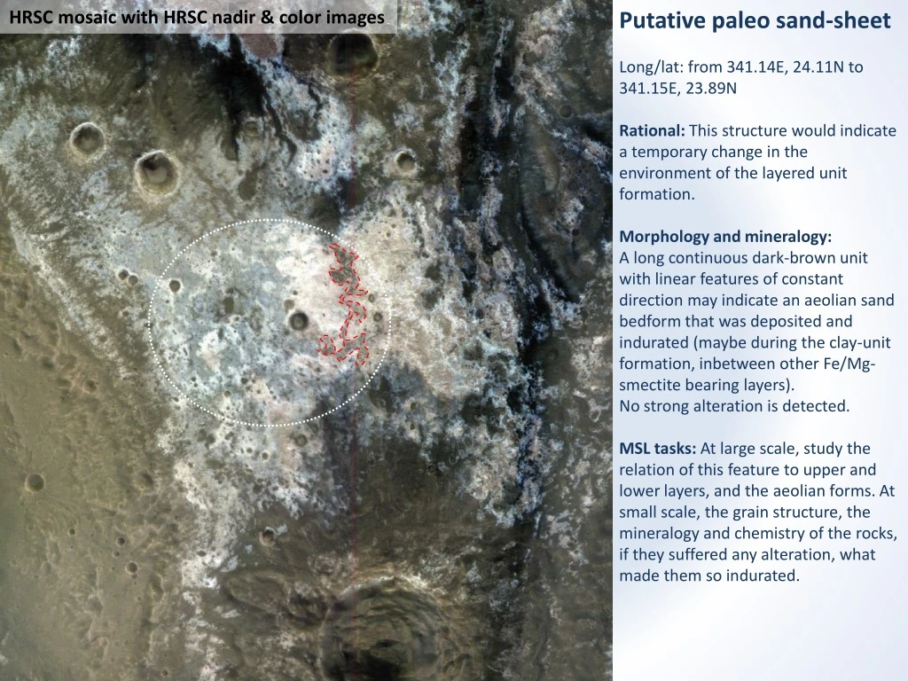
HRSC mosaic with HRSC nadir & color images. Putative paleo sand-sheet Long/lat: from 341.14E, 24.11N to 341.15E, 23.89N Rational: This structure would indicate a temporary change in the environment of the layered unit formation. Morphology and mineralogy:

E N D
HRSC mosaic with HRSC nadir & color images Putative paleo sand-sheet Long/lat: from 341.14E, 24.11N to 341.15E, 23.89N Rational: This structure would indicate a temporary change in the environment of the layered unit formation. Morphology and mineralogy: A long continuous dark-brown unit with linear features of constant direction may indicate an aeolian sand bedform that was deposited and indurated (maybe during the clay-unit formation, inbetween other Fe/Mg-smectite bearing layers). No strong alteration is detected. MSL tasks:At large scale, study the relation of this feature to upper and lower layers, and the aeolian forms. At small scale, the grain structure, the mineralogy and chemistry of the rocks, if they suffered any alteration, what made them so indurated.
Observation: We observe a long continuous dark-brown unit (mapped in the next slide) in the ellipse that differ from the dark cap that is present in many places on the plateau. It does not seem to be altered but its different color from the cap may reveal a different composition. 2 km HiRISE mosaic with HiRISE color images
2 km HiRISE mosaic with HiRISE color images
It has a strong thermal inertia, slightly stronger than the light toned clay unit, and much stronger than the general dark cap. 2 km First close-up HiRISE mosaic with THEMIS Thermal Inertia map (Fergason, R. L.)
Its morphology indicate a varying thickness of not more than few meters, with linear features of a constant direction (NW-SE). 200 m HiRISE mosaic with HiRISE color images
Its continuous nature through the ellipse, at a ~constant elevation may indicate that it is a layer inside the light-toned clay unit. 100 m HiRISE mosaic with HiRISE color images
100 m Possible upper layer Paleo sand-sheet Possible lower layer HiRISE mosaic with HiRISE color images