Download
1 / 45
450 likes | 566 Vues
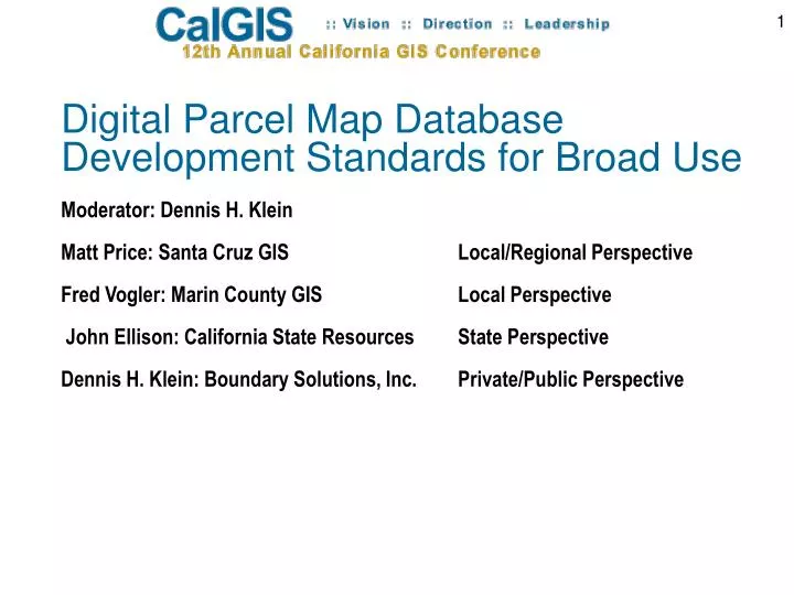
Digital Parcel Map Database Development Standards for Broad Use Moderator: Dennis H. Klein Matt Price: Santa Cruz GIS Local/Regional Perspective Fred Vogler: Marin County GIS Local Perspective John Ellison: California State Resources State Perspective

E N D
Digital Parcel Map Database Development Standards for Broad Use Moderator: Dennis H. Klein Matt Price: Santa Cruz GIS Local/Regional Perspective Fred Vogler: Marin County GIS Local Perspective John Ellison: California State Resources State Perspective Dennis H. Klein: Boundary Solutions, Inc. Private/Public Perspective
Matt Price: Santa Cruz GIS ManagerLOCAL/REGIONAL PERSPECTIVE Digital Parcel Map Standards • Questions • Answers • More Questions • Case Study – National Map
Why Spatial Data Standards? To maximize data sharing while minimizing the duplication of effort between all levels of users and providers of spatial data.
Standards for what? • Spatial Data Standardsapply on many levels: • Data Format (Shapefile, Geodatasbase) • File Naming ( i.e. ‘AssessorsParcels’ v. ‘Parcels’ ) • Thematic Attributes and Table Linkages (APN v. Parcel_ID) • Positional Accuracy • Maps Symbols • Map Projections
Why is this so Difficult? • Challenge of Scope County-Regional-State-Federal (NSDI) • Costly to implement • Some variation will be required • Data maintenance practices and software used may have impact. • No definition has been developed with regards to what parcel level data is required to make a cadastral data set complete.
What Spatial Data Standards / Models Already Exist? • For Parcel Data: • NSDI Cadastral Data Content Standard • Oakland County Michigan Data Model • Local Standards
Case Study – National Map • Goal is to develop repeatable process for compiling local data into a regional format. • Assumptions: • Standard is in place (USGS BP_08_22_2005a). • Local Government agrees to document and cross walk local data field names to National Map field naming convention (in a standard format) and provide data (in a standard format). • No changes to existing format of local data.
State Data Regional Data Regional Data Local Data Local Data Local Data Local Data Local Data Local Data NationalMap
Case Study – National Map • Application Steps: • Re-project local data from state plane to National Mapprojection. • Add fields to projected layer from • National Map and Calculate values • Query target data and delete portion of data of layer • being updated. • Load data into target data.
Case Study – National Map National Map data model was not designed to help local government Cross-walk local data to it. National Map data models do not explicitly identify what data is coming from local sources. Field names in model are longer than ten characters.
Case Study – National Map FIPS Code or local identifier is not present in all layers with local government as likely source. Not clear how permanent identifier present in National Map data will be maintained if local data is source for updates. Need to edge-match and agree on county boundaries.
Define what you are developing standards for: Format Naming Attribute Symbology Projections Keep them simple to start. Build repeatable process based on existing data formats. Summary
Fred Vogler, Marin County GIS ManagerLOCAL/REGIONAL PERSPECTIVE Incentive for Digital Parcel Map Standards
Incentive for Standards As GIS becomes more commonplace, more geodata flows into the public domain, first as a stream and then as a river, pushing up interest in using spatial data. Part of this interest is integrating maps and attributes from various areas and agencies, very difficult without standards. A very good place to start is the Federal Geographic Data Committee’s data “framework”.
Incentive for Standards As with networks, the power and effectiveness of GIS data increases as more people use them and contribute to geodata scope and currency. For Example, the USGS “geospatial one-stop” and the National Map. This in turn intensifies the need for standards.
Incentive for Standards • Integrating Assessor parcel maps, for example, from various counties would be facilitated by a common standard for: • Identifying the parcel number • Owners name • Street address • Other common fields associated with parcels
MarinMap Established Standards A consortium of public agencies in Marin County has cooperated to build a countywide GIS with many spatial data layers staring with the FGDC “framework” layers mentioned above. A set of data structure and field names standards were adopted to effectively read and share data across jurisdictions. To the extent that the Federal Geographic Data Committee had standards, these were used.
Incentive for Standards MarinMap developed standards that meet the needs of the most common or mission-critical business needs such as: - Emergency response - Property owner notification, - Infrastructure maintenance).
Incentive for Standards Taking the idea “to the next level” … The Bay Area regional GIS Council is building a region-wide GIS data center for the nine San Francisco Bay Area counties. A key goal is to enable all emergency responders to reference a standardized set of maps with standardized attributes for the region.
Incentive for Standards Some say form follows function. For GIS, it could be said that use follows availability. Even more use follows standardized availability.
John Ellison: California State Resources State Perspective Why Digital Parcel Map Standards?
22 Why Digital Parcel Map Standards? “The nice thing about standards is that there are so many of them to choose from.” Andrew S. Tanenbaum
23 Why Digital Parcel Map Standards? Highly Desirable - Improved interoperability and clarity of communication between organizations. - Competent machine to machine data exchange that frees us to focus on far more valuable pursuits like transforming the data into information and, eventually, knowledge.
24 • Why • Digital Parcel Map Standards? • Road to Improved Interoperability and clarity is paved with … • Consensus on basic data formats. • Commonly adopted data exchange definitions and protocols.
25 Why Digital Parcel Map Standards? Without consensus, Murphy’s 11th Law will always rule … “If something can be described differently by different people, it will.”
26 Why Digital Parcel Map Standards? Most seasoned GIS professionals have experienced the travails and wasted time of trying to merge spatial data with highly disparate … - Field names and other feature class naming conventions. - Data structures, scopes, annotation, and other format protocols. Ditto incompetent metadata.
27 • Why • Digital Parcel Map Standards? • Suggestions. • Highest initial priority given to expediting multi-jurisdictional o Data Exchange • o Data Assembly - - seamless regional and state GIS maps.
28 • Why • Digital Parcel Map Standards? • Suggestions. • - Avoid imposing uniformity among operational systems because: • o This is dangerous. • o Legacy systems come with their designer’s long standing “world view”. • o Large prior investment of time and egos impede consensus. • o Not enough ROI from reengineering systems for easier data sharing.
29 • Why • Digital Parcel Map Standards? • Suggestions. • - Identify data structure and format protocols most easily complied with by all that offer easier data sharing / assembly the most. • - Once identified, urge adoption by all parcel data sponsors.
Dennis H. Klein Boundary Solutions, Inc.PRIVATE/PUBLIC PERSPECTIVE Digital Parcel Map Database Development Standards for Broad Use
Dennis H. Klein Boundary Solutions, Inc.PRIVATE/PUBLIC PERSPECTIVE Digital Parcel Map Database Development Standards for Broad Use • Classic Private Sector Data Model • Bumps and Grinds in the way of Easy Amalgamation. • Re-Projecting Maps • - Joining GIS to Tax Rolls and Commercial Tax Records- Annotation • - Naming Conventions • Emerging Most Common Practice
Classic Data Model Entering an address and being returned a parcel map with - Subject parcel boundary in the center of the screen.- Display of linked tax record attributes - Street names displayed within ROW.
QUESTION … What are the Bumps and Grinds in the way of …
QUESTION … What are the Bumps and Grinds in the way of doing this easily?
BUMP AND GIND 1. No or Bad Map Projection Files Some deploy data without a projection description (i.e., .prj). Some deploy with a projection file but it is wrong because …the out-of-the-box digital parcel map does not re-project correctly. Some deploy without description file but state the projection in the supporting metadata record but it is wrong. FINALLY, some deploy with a correct description file and/or correct metadata. Hats off to you for eliminating a big bump and grind.
BUMP AND GIND 1. No or Bad Map Projection Files Stanley County, NC TIGER FILE COUNTY BOUNDRY NAD83 Lat Long World Degrees Stanley County, NC With Parcel File Re-Projected to View it within the TIGER County Boundary. IF YES, Projection file Correct. IF NO, Projection file Needs Correction.
BUMP AND GIND 2. No Street Annotation Many deploy with the digital street centerline map produced by the data sponsor agency. This eliminates the Bump and Grind of not having common protocols for street annotation.
BUMP AND GIND 2. No Street Annotation When all locally produced street centerlines are available in universal format (SHP), then all maps can have high quality standard right-of-way annotation. Digital parcel maps require In-ROW annotation so that the display of the parcel boundaries is uncluttered by street annotation.
BUMP AND GRIND 3. Not Able to join Tax Rolls to the GIS.Surprisingly, many jurisdictions have never thought to do this and when they try, they can’t, but is a must for map amalgamation.
BUMP AND GRIND 4. Not Able to join Commercial Tax Records to the GIS.Much more often, APN/PID/PIN attribute protocols used by the GIS have no or little commonality with the one shared with financial institutions.
BUMP AND GRIND 5.Inconsistent Theme / Layer Names Emerging Most Common PracticeTheme 1. Parcels.shp Parcel Layer Theme 2. Roads.shp Street Annotation Layer (Row Annotation) Theme 3. County.shp County Boundary (quality assurance)
BUMP AND GRIND 5.Inconsistent Field Names Emerging Most Common PracticeAPNPID/PIN/PARNO index field name (MANDATORY) Only mandatory field in Database Table. Equals values Assessor shares with title companies. FULLSITUS (NOT MANDATORY) Street Number, Street Name, City, Zip
BUMP AND GRIND 5.Inconsistent View Conventions Emerging Most Common Practice Only one view. View name = Name of Jurisdiction (i.e., Montgomery County, MD)
PRIVATE SECTOR INTERESTS Easy assemblage of multi-county spatial databases including joined tax record data. Statewide and National Cadastre Suitable for supporting National Insurance Operations National Banking/Financing Operations National Emergency Response Operations Others