Download
1 / 12
120 likes | 308 Vues
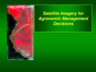
Using Satellite Imagery for Variable Rate Maps. Curtis Dick. What Satellite Imagery is useful for. Designating Management Zones Building Variable Rate Maps Helping Identify Problems in Growing fields Help identifying where to soil sample Measuring Biomass. Satellite Imagery Technology.

E N D
Using Satellite Imagery for Variable Rate Maps Curtis Dick
What Satellite Imagery is useful for • Designating Management Zones • Building Variable Rate Maps • Helping Identify Problems in Growing fields • Help identifying where to soil sample • Measuring Biomass
Satellite Imagery Technology • Agri-ImiGIS • Started in 1994 in North Dakota by providing satellite images for a variety of farming applications • Currently provide 2 types of images (both have NDVI capabilities) • Main use is for building management zones • Also provide products that allows producers to have access to the system via an app • The products allow for soil sampling and other practices to be tied into the imagery into a browser base
Landsat vs. Rapid Eye Landsat Rapid Eye
Major Uses in Oklahoma • A very successful use in Oklahoma has been with variable rate Growth Regulator in Cotton Production • The Images allow a producer or consultant to see the differences in a growing field • Landsat is updated every 16 days no matter if there is cloud cover or not • Rapid Eye takes 4-5 pictures during a growing season and will stay in an area until it gets a clear picture
Hard to tell in a growing field the amount of an input certain plants need
Drones • Around 140 different type of drones available for use • Prices range from $100,000 to $12,800 • As of right now primary purpose is for surveillance
senseFly • Switzerland based company that produces two types of Drones • Swinglet CAM • eBee
Are Drones Useful? Advantages Disadvantages • Are very easy to operate • Does not matter if it is cloudy • Can have an image of a field in 1 day • Do not fly well in winds over 25 mph • Are somewhat costly • If drones are being used commercially they can not be flown over 400 ft elevation in U.S.
Using Drones for Mapping NDVI Vs Green Seeker • Swinglet Cam • http://farmindustrynews.com/crop-protection/drone-plane-your-future-0 • Green Seeker
Review • Best use of satellite imagery seems to be to measure biomass • Satellite imagery is a useful tool in developing management zones, but should probably not be the only information the zones are based off of. • Drones for commercial purposes must be flown below 400ft.