Download
1 / 19
190 likes | 330 Vues
DNDC-EUROPE Adrian Leip, Joint Research Centre. DNDC-EUROPE: quick description of concept and status Improvement of HSMU-layer for improved land use map and simulation units Preparing cross-compliance simulations. DNDC-EUROPE. Socio-economic database. GIS environmental database.

E N D
DNDC-EUROPE Adrian Leip, Joint Research Centre • DNDC-EUROPE: quick description of concept and status • Improvement of HSMU-layer for improved land use map and simulation units • Preparing cross-compliance simulations
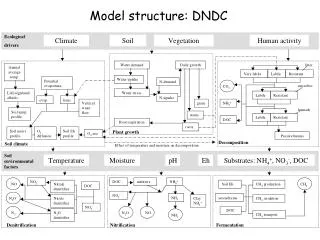
DNDC-EUROPE Socio-economic database GIS environmental database European national and international statistics Geographic data Climate data and N deposition CAPRI DNDC Policy framework National market/trade Definition of environmental scenario Soil information Global trade framework Farm Management Regional agricultural system + economic and environmental indicators Aggregation to modeling spatial units Regional statistics Agricultural land use map Production level and farm input estimation at spatial calculation units Simulation at modeling spatial unit • Environmental indicators • - N2O, N2 • NOx • CH4 • NH3 • Nitrate leaching • Carbon Stocks • Livestock density • … Developed in CAPRI-DynaSpat
DNDC-EUROPE 1. Geographic information 2. Link to climate file GIS database for individual simulation units 3. Soil data Climate library (including deposition) 4. Cropping information# 5. Farm management data$ Output(one file per simulation year) 6. Crop physiological data$ 7. Initialization for winter crops$
…. Soil Map again Relative decrease of organic carbon stocks Relative decrease of N2O fluxes
The model calculates full balance of nitrogen, carbon and water • Spatial resolution: from 1 km-pixel to continental • matching of environmen-tal conditions with anthropogenic activities • Temporal resolution of the model is <= 1 h for some processes
Short-term improvements • Realistic weather from 1975 – 2005 • Slightly improved fertilizer and manure distribution • Estimation of potential yield • Higher number of HSMU • DNDC on windows and unix computers • Distributed simulation
Improved version of the HSMU layer • HMU • (Homogeneous Mapping Units): • Individual ID for the intersection of • Slope • Administrative borders • Soil mapping units • Soil typological units • HSMU: • (Homogeneous Soil Modelling Units) • Dissolve SMU layer • HSMU-II will not be georeferenced • … but ‘pure’ from viewpoint of environmental characteristics • NCU: • Aggregation of the STU • Result will be an update of the old HSMU layer with Corine resolved (as discussed in Paestum) NITRO-EUROPE CCAT
2. Corine will NOT be used any more to delineate the HSMU • Reduction of the number of the HSMU (relevant for the generation of the agri-land use map) • Corine 100 m will be used to calculate “land cover shares” in HSMUs
3. Working at the STU-level • without Corine and with STU there are 104000 HSMU for EU25 • transparent application of pedo-transfer rules ….
Simulating cross-compliance • Set up default run on the basis of CC measures and compliance assumptions • Review of the parameterization of important management activities • Tillage • Irrigation • Fertilizer application • Two Tier-approach • Simple implementation fo CC measures to screen a wide range of measures • More detailed evaluation of most sensitive measures
Simulating cross-compliance (cont’d) • More attention to crop-specific data (genetic variability, regional differences) • Continue to work on nitrogen application rates • Focus of simulations: • NEU: EU-GHG balance of arable soils • CCAT: specific crops/scenarios