Download
1 / 1
10 likes | 60 Vues
Cayambe. Pambamarca Fortress Complex. Caranqui Forts. El Quinche. Why Here? Understanding the Location of the Pambamarca Fortress Complex Eric Dyrdahl Department of Anthropology, Northwestern University. Introduction

E N D
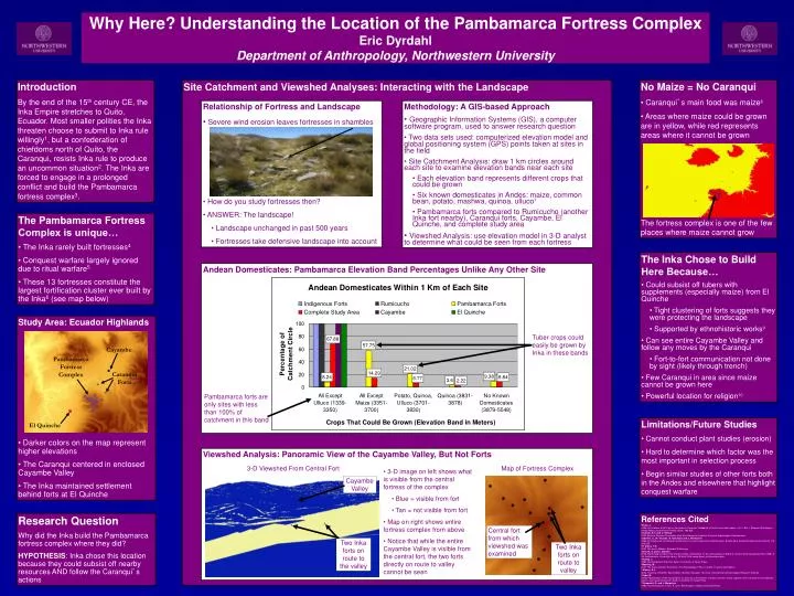
Cayambe Pambamarca Fortress Complex Caranqui Forts El Quinche Why Here? Understanding the Location of the Pambamarca Fortress Complex Eric Dyrdahl Department of Anthropology, Northwestern University Introduction By the end of the 15th century CE, the Inka Empire stretches to Quito, Ecuador. Most smaller polities the Inka threaten choose to submit to Inka rule willingly1, but a confederation of chiefdoms north of Quito, the Caranqui, resists Inka rule to produce an uncommon situation2. The Inka are forced to engage in a prolonged conflict and build the Pambamarca fortress complex3. Site Catchment and Viewshed Analyses: Interacting with the Landscape • No Maize = No Caranqui • Caranqui’s main food was maize8 • Areas where maize could be grown are in yellow, while red represents areas where it cannot be grown • The fortress complex is one of the few places where maize cannot grow • Relationship of Fortress and Landscape • Severe wind erosion leaves fortresses in shambles • How do you study fortresses then? • ANSWER: The landscape! • Landscape unchanged in past 500 years • Fortresses take defensive landscape into account • Methodology: A GIS-based Approach • Geographic Information Systems (GIS), a computer software program, used to answer research question • Two data sets used: computerized elevation model and global positioning system (GPS) points taken at sites in the field • Site Catchment Analysis: draw 1 km circles around each site to examine elevation bands near each site • Each elevation band represents different crops that could be grown • Six known domesticates in Andes: maize, common bean, potato, mashwa, quinoa, ulluco7 • Pambamarca forts compared to Rumicucho (another Inka fort nearby), Caranqui forts, Cayambe, El Quinche, and complete study area • Viewshed Analysis: use elevation model in 3-D analyst to determine what could be seen from each fortress • The Pambamarca Fortress Complex is unique… • The Inka rarely built fortresses4 • Conquest warfare largely ignored due to ritual warfare5 • These 13 fortresses constitute the largest fortification cluster ever built by the Inka6 (see map below) • The Inka Chose to Build Here Because… • Could subsist off tubers with supplements (especially maize) from El Quinche • Tight clustering of forts suggests they were protecting the landscape • Supported by ethnohistoric works9 • Can see entire Cayambe Valley and follow any moves by the Caranqui • Fort-to-fort communication not done by sight (likely through trench) • Few Caranqui in area since maize cannot be grown here • Powerful location for religion10 Andean Domesticates: Pambamarca Elevation Band Percentages Unlike Any Other Site • Study Area: Ecuador Highlands • Darker colors on the map represent higher elevations • The Caranqui centered in enclosed Cayambe Valley • The Inka maintained settlement behind forts at El Quinche Tuber crops could easily be grown by Inka in these bands Pambamarca forts are only sites with less than 100% of catchment in this band • Limitations/Future Studies • Cannot conduct plant studies (erosion) • Hard to determine which factor was the most important in selection process • Begin similar studies of other forts both in the Andes and elsewhere that highlight conquest warfare Viewshed Analysis: Panoramic View of the Cayambe Valley, But Not Forts 3-D Viewshed From Central Fort Map of Fortress Complex • 3-D image on left shows what is visible from the central fortress of the complex • Blue = visible from fort • Tan = not visible from fort • Map on right shows entire fortress complex from above • Notice that while the entire Cayambe Valley is visible from the central fort, the two forts directly on route to valley cannot be seen Cayambe Valley Research Question Why did the Inka build the Pambamarca fortress complex where they did? HYPOTHESIS: Inka chose this location because they could subsist off nearby resources AND follow the Caranqui’s actions References Cited 1Rowe, J. 1946 Inca Culture at the Time of the Spanish Conquest. Handbook of South American Indians. Vol. 2. Ed. J. Steward. Washington: United States Government Printing Office. 183-330. 2Connell, S.V. and C. Gifford 2003 National Science Foundation High-Risk Research Proposal. Proyecto Arqueológico Pambamarca. 3Oberem, U., W. Wurster, R. Hartmann and J. Wentscher 1969 La fortaleza de montaña de Quitoloma en la sierra septentrional del Ecuador. Boletín de la Academic Nacional de Historia 114: 196-205. 4D’Altroy, T.N. 2002 The Incas. Malden: Blackwell Publishing. 5Arkush, E. and C. Stanish 2005 Interpreting Conflict in the Ancient Andes: Implications for the Archaeology of Warfare. Current Anthropology 46 (Feb. 2005): 3-28. Northwestern University Library. 26 May 2006 <www.library.northwestern.edu>. 6Hyslop, J. 1990Inka Settlement Planning. Austin: University of Texas Press. 7Moseley, M. 2001 The Incas and their Ancestors: The Archaeology of Peru. London: Thames and Hudson. 8 Athens, S.J. 2003 Inventory of Earthen Mound Sites, Northern Ecuador. Honolulu: International Archaeological Research Institute. 9Cobo, B. 1979 [1953] History of the Inca Empire: an account of the Indians' customs and their origin, together with a treatise on Inca legends, history, and social institutions. Austin: University of Texas Press. 10Gasparini, G. and L. Margolies 1980 Inca Architecture. Trans. P. Lyon. Bloomington: Indiana University Press. Central fort from which viewshed was examined Two Inka forts on route to the valley Two Inka forts on route to valley