Download
1 / 56
820 likes | 1.28k Vues
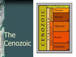
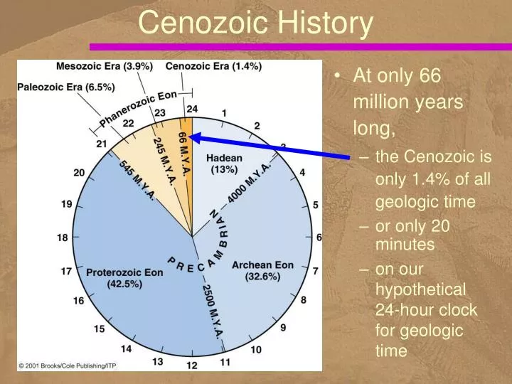
Cenozoic History . At only 66 million years long, the Cenozoic is only 1.4% of all geologic time or only 20 minutes on our hypothetical 24-hour clock for geologic time. Cenozoic Time Scale. In this class we use the term Tertiary Period rather than Paleogene and Neogene Periods.

E N D
Cenozoic History • At only 66 million years long, • the Cenozoic is only 1.4% of all geologic time • or only 20 minutes • on our hypothetical 24-hour clock for geologic time
Cenozoic Time Scale • In this class we use • the term Tertiary Period • rather than Paleogene and Neogene Periods
Late Cretaceous Rifts separate Africa and South America and then India, Australia, Antarctica. North America rifts from Europe. Old Gondwana (Africa, India, Australia) move north toward Eurasia, closing the Tethys Ocean and forming the Alpine-Himalayan mountains. The Atlantic lengthens / widens, the Sevier orogeny continues, and the Caribbean arc forms. Texas 65-144 Ma: continuing shallow limestone and shale deposition to the southeast (from Rockies). http://vishnu.glg.nau.edu/rcb/globaltext.html
Paleocene / Eocene Himalayan Orogeny. Alps and Pyrenees form. The modern patterns of geography appear. Atlantic continues to open. Rocky Mountains grow. Texas 65 - 35 Ma: shale and sandstone in southeast region prograde shoreline (from the Rockies). Volcanic activity in Panhandle. http://vishnu.glg.nau.edu/rcb/globaltext.html
Cenozoic Plate Tectonics • By Eocene time, • the Americas had completely separated • from Europe and Africa • but India had not yet collided with Eurasia
Oligocene and Miocene Orogeny continues in the Mediterranean region and India nears its junction with southern Asia. Antarctica isolated. Southwestern North America intercepts the East Pacific Rise and a great extensional event, the Basin and Range orogeny begins. Texas 35-5 Ma: continued sandstone/shale deposition and progradation of shoreline (erosion of Rockies) http://vishnu.glg.nau.edu/rcb/globaltext.html
Cenozoic Plate Tectonics • During Miocene time, • the Atlantic Ocean basin continued to widen • and India had collided with Eurasia • The Tethys Sea between Africa and Eurasia • was mostly closed by this time
East African Rift • A triple junction • joins the East African Rift System • to the Gulf of Aden • and the Red Sea • Oceanic crust began forming • in the Gulf of Aden about 10 million years ago • Red Sea rifting began later and oceanic crust is now forming
Orogenic Belts • Circum-Pacific orogenic belt and the Alpine-Himalayan orogenic belt are the sites of most recent geologic and orogenic activity
Closure of the Tethys Sea • Remember that during Mesozoic time • the Tethys Sea separated much of Gondwana • from Eurasia • Closure of this sea • took place during the Cenozoic • as the African and Indian plates • collided with the huge landmass to the north
Cenozoic Plate Tectonics • Eocene time
Cenozoic Plate Tectonics • Miocene time
The Himalayas • During the Early Cretaceous, • India broke away from Gondwana • and began moving north, • and oceanic lithosphere was consumed • at a subduction zone • along the southern margin of Asia
Before India Collided with Asia • Oceanic lithosphere • subducted beneath southern Tibet • as India approached Asia northern margin of India southern margin of Tibet
India Collided with Asia • About 40 to 50 million years ago • India collided with Asia, • but because India was to light to subduct, • it thrust under Asia
Continued Convergence • Thrusting of Asian rocks • onto the Indian subcontinent • accompanied continued convergence
India Moved beneath Asia • Since about 10 million years ago, • India has moved beneath Asia • along the main boundary fault • Shallow marine sedimentary rocks • that were deposited along India’s northern margin • now form the higher parts of the Himalayas
Evolution of the Andes Mountains • Prior to 200 million years ago, • the west coast of South America • was a passive continental margin • where huge quantities of sediment were deposited
Evolution of the Andes Mountains • Orogeny began when this area • became an active continental margin • as South America moved to the west • and collided with oceanic lithosphere
Evolution of the Andes Mountains • Deformation, volcanism and plutonism continued
The North American Cordillera • The North American Cordillera • is one large segment of the circum-Pacific orogenic belt • extending from Alaska to central Mexico • In the United States it widens to 1200 km • stretching east-west • from the eastern flank of the Rocky Mountains • to the Pacific Ocean
Cordillera • North American Cordillera • and the major provinces • of the United States and Canada
Sedimentary Basins in the West • Locations of Proterozoic sedimentary Basins • in the western United States and Canada • Belt Basin • Uinta Basin • Apache Basin
Cordilleran Mobile Belt Antler Orogeny in Devonian
Cordillera Evolved • After Laramide deformation, Cordillera continued to evolve • large-scale block-faulting • extensive volcanism • vertical uplift and deep erosion • Basin and Range • During about the first half of the Cenozoic Era, a subduction zone was present • along the entire western margin of the Cordillera, • but now most of it is a transform plate boundary • ???
Plate Interactions Continue http://earth.geol.ksu.edu/sgao/research/data/seiswus/example1.gif
The Laramide Orogeny • Third in a series of deformational events • in the Cordillera beginning during the Late Jurassic • Late Cretaceous to Eocene • Differed from the previous orogenies in important ways
Laramide orogeny • took place as the Farallon plate, • buoyed up by a mantle plume • subducted beneath North America • at a decreasing angle • and igneous activity shifted inland ???
Change to Shallow Subduction • By Early Tertiary time, • the westward-moving North American plate • had overridden the part of the Farallon plate, • above the head of the mantle plume • The lithosphere • immediately above this plume • was buoyed up, • accounting for a change • from steep to shallow subduction
Igneous Activity Ceased • With nearly horizontal subduction, • igneous activity ceased • and the continental crust • was deformed mostly by vertical uplift
Renewed Igneous Activity • Disruption of the oceanic plate • by the mantle plume • marked the onset • of renewed igneous activity
Cordilleran Igneous Activity • The vast batholiths in • Idaho • British Columbia • Sierra Nevada of California • were emplaced during the Mesozoic Era • intrusive activity continued into Tertiary http://www.bhc.edu/academics/science/harwoodr/GEOL102/Study/Images/BatholithsNA.gif
Tertiary Volcanism • more or less continuous in the Cordillera • varied in intensity, eruptive style, and location • ceased temporarily in the area of the Laramide orogen
Columbia River Basalts • an aggregate thickness of about 2500 m • well exposed in the walls of the deep gorges • cut by the Columbia and Snake rivers • Some of the individual flows were truly phenomenal • Roza flow alone covers 40,000 km2 and has been traced about 300 km from its source ~ 20 lava flows of the Columbia River basalts exposed in the canyon of the Grand Ronde River in Washington
Cascade Range • Some of the highest mountains in the Cordillera are the Cascades • California, Oregon, Washington, British Columbia • Thousands of volcanic vents are present • dozen large volcanoes • Lassen Peak in California • world's largest lava dome • Related to subduction of the Juan de Fuca plate http://www.cr.nps.gov/history/online_books/resedu/resedu2a.htm
Basin and Range Province • Generalized cross section of the Basin and Range Province • ranges are bounded by faults
Colorado Plateau • Mesozoic sedimentary rocks in the Valley of the Gods, Utah • Paleozoic rocks exposed in the Grand Canyon, Arizona
Colorado Plateau • Mesozoic sedimentary rocks at Colorado National Monument, Colorado
Pacific Coast • Before the Eocene, • the entire Pacific Coast was a convergent plate boundary • Farallon plate was consumed at a subduction zone • stretched from Mexico to Alaska
Change from Subduction • As the North American Plate • overrode the Pacific–Farallon Ridge, • its margin became transform faults • the San Andreas • and the Queen Charlotte • alternating with subduction zones
Extending the San Andreas Fault • Further overriding of the ridge • extended the San Andreas Fault • and diminished the size of the Farallon–Plate remnants • Now only two small remnants • of the Farallon plate exist • the Juan de Fuca and Cocos plates
The Continental Interior • A vast area called the Interior Lowlands • the Great Plains • and the Central Lowlands
Cenozoic History of the Appalachian Mountains • Deformation in the Appalachians has a long history • began during the Late Proterozoic • during Late Triassic time, the entire region experienced faulting as Pangaea fragmented
Reduced to Plains • By the end of the Mesozoic • erosion had reduced the mountains to a plain across which streams flowed eastward to the ocean
Appalachians in the Tertiary • Streams developed across the plains during the Tertiary