Download
1 / 100
1.41k likes | 2.91k Vues
Political Geography. How humans define and control land and its resources. Political Geography Basics. Political geography is study of human political organization of the earth at various geographic levels Study spatial layout of political organizations at, above and below country level

E N D
Political Geography How humans define and control land and its resources.
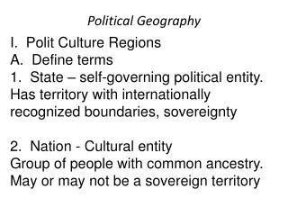
Political Geography Basics • Political geography is study of human political organization of the earth at various geographic levels • Study spatial layout of political organizations at, above and below country level • Above country level study organizations like the United Nations • At country level, study organization of government and boundaries • Below country level can study voting districts of local politics
Personal Space • Territoriality applies on a personal level as well as a country level • Personal space defined: area we claim as our own territory into which others may not enter without our permission • When someone crosses into your personal space, how do you respond? • Can this be applied to countries? • How big your personal space is depends from person to person • Example: people from a small town may have larger areas of personal space than someone from a larger city like New York. Why is that?
Territorial Dimensions of Politics • Territoriality: creating ownership over a defined space • Can be space as small as bedroom to as large as a country • Typically evokes and emotional response • Some people think territoriality of humans is similar to that of animal’s aggressive defense of territory but others argue humans can make allowances that animals can’t • Examples: Iraq’s invasion of Kuwait, Germany’s invasion of Poland in 1939 and passport control
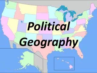
State vs. Nation • State: (State with a capital “S”) political unit with a permanent population, territorial boundaries that are recognized by other states, an effective government, a working economy and sovereignty. • Sovereignty defined: internationally recognized control a state has over the people and territory within its boundaries • State can be used interchangeably with country • state (with a small “s”) is like Utah • Nation: a group of people who share a common culture and identify as a cohesive group • People are often willing to fight on behalf of their nationality
More on States and Nations • Over 200 states in the world today • Is the United States a nation or a state? • If the U.S. is a nation, what makes it a nation? • Nation-State: a state with only one nation within its borders • Example: Iceland and Japan • Stateless-nation: when a nation does not have a territory to call its own • Example: Assyrian Christians or Kurds of Iraq or Ughirs of western China • Multinational states: a state the includes more than one nation within its borders • Example: United States or Russia
Political Systems • Organization of government • Many different types but main ones are • Theocracy: rule of religious elite • Monarchy: rule by one person, usually king or queen • Totalitarian: rule using fear, force and media • Democratic Republics: rule of the people through representatives • Many types but most common are Presidential and Parliamentary systems
Federal Governmental Structures • Defined: government with a central government and strong regional governments that share power with the central government • Examples: United States and Germany • This type of government works well in geographically large areas • Can create problems if the autonomous region wants to break away. • Opposite of a Unitary system.
Confederate Governmental Structure • Defined: where a weak central government exists with regional governments holding most of the power • Examples: Articles of Confederation and the United States • Usually seen in countries that are afraid of a strong central government
Basic Political Beliefs • The “left” vs. the “right” • It is not just Republican vs. Democrat • Left Ideas • Government is the answer • Right Ideas • Less government is the answer
Ethnicity • Defined: identity with a group of people who share cultural traditions of a particular homeland or hearth • Race: identity with a group of people who share a biological ancestor • Ethnicities tend to cluster together sometimes leading to tension and violence between groups • Example: African-Americans and Caucasion Americans • Oftimes, ethnic groups give rise to nations creating political systems
Ethno nationalism and Conflict • Ethno nationalism: powerful emotional attachment to one’s nation that is a minority within a state and feels different from the rest of the state’s people • Occurs when minority nations feel they do not have enough self-determination (power to control their own territory and destiny) • Ethno nationalism can lead to great amounts of conflict • Examples: Chechnya and Russia
Ethnic Cleansing • Defined: process in which a more powerful ethnic group forcibly removes a less powerful one in order to create an ethnically homogeneous region • Often a consequence of ethnonationalism • Examples: the Former Yugoslavia, Rwanda, Hitler
Buffer States • Defined: independent country located between two larger countries that are in conflict • Created to try and calm two conflicting states or prevent them from further violence • Russia and China have historically fought, Mongolia has helped reduce direct confrontation between the two countries • Brazil and Argentina historically have fought so country of Uruguay was created
Buffer Zone • Defined: two or more countries sit between two larger countries in conflict • Historical example was eastern Europe • Eastern Europe separated Western Europe (NATO States) and Soviet Union (communist country) • Problem was Soviets tried to dominate buffer zone
Satellite States • Defined: countries controlled by another, more powerful state • Can happen in buffer zones but it doesn’t have to be that way • Example: Poland was satellite state of the Soviet Union where Moscow controlled it almost as tightly as a colony • Creation of satellite states in Eastern Europe created what Winston Churchill called the “iron curtain”
Shatter Belt • Defined: state or group of states that exists within a sphere of competition between larger states • Typically high levels of violence in these areas • Often victims of innovations, boundary changes and poor economic development • Historical example: Poland between Germany and Soviet Union in World War II • Current example: Transcaucasia
Boundaries • Important because boundaries are often at the root of many conflicts of varying scales • Our lives are shaped by boundaries • Neighbors or your yard • City to city • State to state • International boundaries: separate states’ territories, extends to define what the state owns above and below the ground • There are many types of political boundaries • Geometric, physical, cultural, antecedent, subsequent, superimposed and relict
Geometric Political Boundaries • Defined: straight-line boundaries that do not relate to the cultural or physical features of the territories involved • Example: North and South Korea, the United States and Canada
Physical (natural) Political Boundaries • Defined: territory separated according to natural features in the landscape like mountains, deserts or rivers • Example: France and Spain, United States and Mexico
Cultural Boundaries • Defined: changes in the cultural landscape-can include things like language or religion • Can be more than one type of boundary at the same time • Examples: Pakistan and India, Spain and Portugal
Antecedent Boundaries • Existed before human cultures developed into their current forms-defined and evolved before present human day landscape • Usually the least likely to experience violence or conflict • Examples: Kentucky and Indiana separated by the Ohio River or Malaysia and Indonesia on the island of Borneo
Subsequent Boundaries • Defined: divide space as a result of human interaction and negotiation after significant settlement has occurred-it has changed over history with attempt to deal with cultural differences • Not as typically non-violent as subsequent but still fairly non-confrontational • Example: United States and Canada
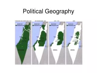
Superimposed Boundaries • Defined: forcibly put on a landscape by outsiders, such as invaders or an organization like the United Nations • Most likely to be violent or have conflict • Example: the modern state of Israel
Relict Boundary • Defined: no longer functions as a boundary but only as a reminder of what once was • Examples: North and South United States, Berlin Wall in Germany
Creation of Boundaries • Many steps should be followed in the creation of a boundary into a final form • Definition: phase in which the exact location of a boundary is legally described and negotiated • Delimitation: step when a boundary’s definition is drawn onto a map • Demarcation: visible marking of a boundary on the landscape with a fence, line, sign, wall or other means • Administration: enforcement by a government or people of the boundary that has been created
Ocean Boundaries • Oceans are very difficult to define and delineate borders on and in • United Nations held the Convention on the Law of the Seas (UNCLOS) where they paved out the following provisions • Coastal states can stake a claim up to 12 nautical miles from their shorelines but ships from other countries can pass through these waters • Coastal state can claim up to 200 nautical miles of territory beyond its shoreline as an exclusive economic zone where the country can explore and mine natural resources that may be in the waters • When there is not enough water for each country on opposite sides of the sea to have 200 nautical miles of exclusive economic zone, the two or more countries involved will divide up the water evenly in a rule called the median-line principle
Frontiers • Defined: regions where boundaries are very thinly or weakly developed, zones where territoriality is unclear and not well established • Can create problems because of questionable government control • In modern world, Antarctica is frontier region • Local communities can have frontier regions between neighborhood boundaries • Be clear that boundaries clear lines but frontiers are REGIONS!
Territorial Morphology • Defined: the relationship between a state’s geographic shape, size, relative location and political situation • In 9th grade English, it is how things like shape, size and location affect the political situations facing the people internally and internationally • 5 classifications of geographic shapes of states: fragmented, elongated, compact, prorupted (also known as protruded) and perforated
Fragmented States • Defined: when a state geographically exists in several pieces • Can create problems in maintaining unity among constituent parts • Examples: Indonesia, Malaysia
Elongated States • Defined: long and thin in shape • Creates problems when state’s power base, or capital, loses influence over one end of the elongation • Can also pose transportation problems • Example: Chili, Vietnam