Download
1 / 18
190 likes | 416 Vues
Chapter 7: Erosion and Deposition. 7.1 : Forces wear down and build up Earth’s surface 7.2 : Moving water shapes land 7.3 : Waves and wind shape land 7.4 : Glaciers carve land and move sediments. 7 .3 : Waves and wind shape land. Before, you learned: Stream systems shape Earth’s surface

E N D
Chapter 7: Erosion and Deposition 7.1: Forces wear down and build up Earth’s surface 7.2: Moving water shapes land 7.3: Waves and wind shape land 7.4: Glaciers carve land and move sediments
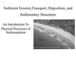
7.3: Waves and wind shape land • Before, you learned: • Stream systems shape Earth’s surface • Groundwater creates caverns and sinkholes • Now, you will learn: • How wave currents shape shorelines • How wind shapes land • Book, p.158: Pillars of Rock, Port Campbell, Australia: • Why do you think these are left over from large areas of rock? • The pillars are made of hard rock that was among softer or fractured rock that was easier to weather and disintegrate
Waves and currents shape shorelines • Port Campbell pillars formed by movement of water • Continuous action of waves breaking against the cliffs • 2 cm/year, and still eroding • Force of wave: powered by wind, can wear away rocks and transport sand • Force of wind: can change the look of land
Shorelines • Can be flat, low, high, steep, rocky, sandy… • High rock cliff: waves crash and wear away bottom rocks • Low coastlines build up • Similar to when a stream flows into an ocean or lake, sediment is deposited near its mouth • This sediment mixes with sediment from waves beating against the coast, building up beaches • Describe movement of sediment and water along the shore: • Longshore drift • Longshore current
Shorelines – Longshore drift • Longshore drift: zigzag movement of sand along a beach • Wind blows across water and may hit the shoreline at an angle • Carries sand to shore, and gravity pulls the water and sand back out to the water • The sand gradually moves down the beach • Moves large amounts of sand along a beach: shrink/grow
Shorelines – Longshore current • Longshore current: movement of water along a shore as waves strike the shore at an angle • Direction may change from day to day as wave direction changes
Oceans, aside • Ocean waves are a movement of energy, not water • A cork in water impacted by a wave moves - it rises and falls on the wave but does not move forward • Water waves move energy, not material • A message in a bottle thrown to sea may arrive cross the sea by currents, rather than waves
Sandbars and Barrier Islands • Longshore currents can deposit sand along shorelines • This sand builds up to form sandbars • A ridge of sand built up by the action of waves and currents • If the sandbar is built up above the water’s surface and is joined to the land, it is called a “spit” • Strong longshore currents that mostly move in one direction over time build up the sandbar intobarrier islands • A long narrow island that develops parallel to a coast • Forms a barrier between the ocean waves and the shore of the mainland • Common along gently sloping coasts: New Jersey, North Carolina, Gulf of Mexico • Constantly change shape
Wind shapes land • Sand dunes…far from a desert or ocean! • Created by wind: • Dune: a mount of sand built up by wind • Like water, wind can transport and deposit sediment • Especially powerful in dry regions where soil is not held in place (few plants) Near Lake Michigan
Wind Shapes Land • Dune formation: • Strong wind picks up and transports sand particles – deposits the sand which builds to dunes • Can start as a ripple then grow larger • Can form as wind-carried sand settles around a rock, log, or other obstacle • Need: strong winds AND constant supply of loose sand • Vary in size an d shape • up to 300 meters (1000 ft), curved, straight, mounds • Typically have a gentle slope facing the wind, and steep on the other side
Loess • Wind also changes soil by depositing dust • Loess: deposits of fine wind-blown sediment • Can build up over thousands or millions of years • Forms good soil for growing crops • Some deposits 300 meters thick! • Ex: China: deposits are 2 million years old • Central U.S.: between 8-30 m (25-100 ft) deep
Desert Pavement • Wind can also remove dust • It blows away sand, silt, and gravel, leaving behind a layer of stones and gravel • Called “desert pavement” because it looks like a cobblestone pavement • What remains is too heavy to be picked up by wind
Coastline video: http://scienceblips.dailyradar.com/video/coastal-erosion-video/ • Videos: • http://gatm.org.uk/geographyatthemovies/coasts.html
Mount kenya is very close to the equator. Estimate the snow line elevation on mount kenya. • Mount rainier is at 47 degrees north latitude and is 4389 meters tall. Can there be glaciers on mount rainier? If so, estimate the elevation above which the glaciers form. • Mount washington in new hampshire is at 45 degrees north latitude and is 1917 meters tall. Can there be glaciers on mount washington? If so, estimate theeir lowest elevation. Challenge: temperatures are hotter at the equator than at 28 degrees north latitude. Why is the snow line lower at the equator in Ecuador?