Download
1 / 31
310 likes | 468 Vues
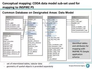
Using WAAS for Sub-meter Mapping. Eric Gakstatter egakstatter@gpsworld.com GPS World magazine Presented September 22, 2009 USSLS/CGSIC Meeting Savannah, GA. WAAS – What is it?. Wide Area Augmentation System

E N D
Using WAAS for Sub-meter Mapping Eric Gakstatter egakstatter@gpsworld.com GPS World magazine Presented September 22, 2009 USSLS/CGSIC Meeting Savannah, GA
WAAS – What is it? • Wide Area Augmentation System • A Federal Aviation Administration (FAA) program that provides GPS integrity monitoring and improves GPS accuracy. • ~$90M-100M annual budget.
WAAS – What is it? • What does WAAS do? • Provides position integrity. GPS alone isn’t reliable enough for aviation navigation. • The specification when using WAAS is that GPS shouldn’t provide an “out of tolerance” position more than 1 in 100,000,000 times. • Provides user notification within six seconds if a position is “out of tolerance”. • Ionospheric modeling. • Position corrections.
WAAS – What is it? • WAAS addresses three GPS error sources; ionospheric error, satellite clock error, satellite ephemeris error. • Error from the ionosphere is the largest and most dynamic. • WAAS models the effect of the ionosphere that it has on GPS signals passing through it.
WAAS – What is it? WAAS consists of: • A network of 38 WAAS Reference Stations (WRS) that are dual frequency (L1/L2) GPS receivers. • Processing facilities. • Geostationary satellites. • Control facilities.
WAAS – What is it? PanAmSat 133°W Telesat 107°W
WAAS – What is it? • Elevation of WAAS PRN 138/SV 51
WAAS – What is it? • Elevation of WAAS PRN 135/SV 48
Trends in GPS mapping It seems that WAAS is all about aviation. How does the surveying/mapping community benefit from WAAS?
Trends in GPS mapping • The survey/mapping community expects smaller, simpler, cheaper GPS sub-meter mapping equipment. • The user community is moving away from post-process differential correction and towards real-time corrections. • What are the choices for real-time DGPS corrections?...
Real-time Correction Sources • WAAS (SBAS): -free, accurate, North American coverage (US/Alaska, Hawaii, Canada, Mexico), Western Europe (EGNOS), MSAS (Japan). India and Russia in planning stage. • Radio-beacon DGPS/NDGPS: -free, accurate, USA coverage (parts of Canada), coastlines of 40+ other countries, extra hardware required. • Commercial DGPS services: -subscription-based, accurate, world-wide coverage, extra hardware required. • RTK networks: -some free/some subscription-based, very accurate, very limited coverage, extra hardware required.
WAAS • All WAAS-enabled receivers aren’t created equal. • WAAS was designed for aviation, but GPS receivers can be designed to optimize WAAS for ground users. • Some manufacturers have introduced high performance GPS L1 mapping receivers that exploit WAAS for ground users.
WAAS • The position integrity bounds (horizontal and vertical) required by the FAA is 99.99999%. Therefore, integrity trumps accuracy. • If that level of integrity is not required, then integrity can be traded for accuracy.
WAAS performance • “Optimizing WAAS Accuracy/Stability For a Single Frequency Receiver.” Kim, Euiho, Walter, T., and Powell, J.D. - Stanford University. • Presented September 2006 at ION 2006. • Modifying the weighting matrix, adaptive carrier smoothing, and nullifying range rate correction.
Examples of WAAS Mapping users Examples of WAAS users around North America…
WAAS Mapping users • J.D. Irving Ltd. • 15,000 employees • Industry: Forest Products • Location: Eastern Canada • Application: Harvesting timber. • 300+ high performance WAAS receivers. “Initially, a number of DGPS options were tested, and WAAS proved to penetrate our forest canopy type the best.”
WAAS Mapping users • State of Pennsylvania • Industry: Forestry • Location: PA • Application: Forestry mapping. • 30 hi-performance WAAS receivers. “We tested against post-processing units in some of the toughest forestry environments we know of. We are extremely pleased with WAAS performance.”
WAAS Mapping users • US Nat’l Park Service • Industry: Gov’t • Location: Sub- Arctic Alaska • Application: Map archaelogical sites • 45 high performance WAAS receivers "Many mapping grade GPS users still do not feel good about relying on WAAS. You can always post-process, but after reading these numbers, some may ask why bother?"
WAAS Mapping users • American Forest Mgt • 250 employees • Industry: Forestry • Location: VA to TX, ME to MI. • Application: Area calcs, road work, land owner mapping. • 25 hi-performance WAAS receivers. “Our field efficiency has drastically increased due to reliable reception and ease of use…office productivity also increased because of real-time correction.”
WAAS Mapping users • Portland General Electric • 2,600 employees • Industry: Utility • Location: Oregon • Application: Utility pole mapping • 15 hi-performance WAAS receivers. Utility Asset Management “Four years ago, we started out using low-end WAAS receivers, but switched to mapping-grade WAAS receivers after 60 days due to accuracy problems. 225,000 poles and four years later, we are still using the same WAAS receivers.”
WAAS Mapping users • State of Minnesota • Industry: Gov’t • Location: Minnesota • Application: Mapping abandoned chem bldgs • 5 hi-performance WAAS receivers. Approximately 500 facilities were mapped using a bluetooth, submeter WAAS GPS and a windows mobile data collector. Wireless technology eliminated connectivity problems and the receivers had Coast technology, consistently giving us submeter, real-time results, even in areas that had poor visibility.
WAAS Mapping users • US Forest Service • Industry: Forestry • Location: N. Mexico • Application: Forestry mapping. • 5 hi-performance WAAS receivers. “Signal reliability is probably 95%. Great reception along a forest road. A differentially-corrected file with no post-processing. That is a HUGE timesaver.”
Watch the manufactures • Both mapping and survey GPS receivers have been introduced that exploit WAAS and the WAAS GEO observables.
Take away messages • WAAS, when exploited for ground users, is an effective source of GPS corrections throughout North America, Europe and Japan. India and Russia are in planning.
Take away messages • WAAS, when exploited for ground users, is an effective source of GPS corrections throughout North America, Europe and Japan. India and Russia are in planning. • The survey/mapping user community clearly prefers a low overhead solution such as WAAS that requires no additional receiver and antenna hardware.
Take away messages • WAAS, when exploited for ground users, is an effective source of GPS corrections throughout North America, Europe and Japan. India and Russia are in planning. • The survey/mapping user community clearly prefers a low overhead solution such as WAAS that requires no additional receiver and antenna hardware. • WAAS, when exploited for ground users, meets the sub-meter accuracy requirements expected of today’s high performance mapping systems.
QUESTIONS? Eric Gakstatter Contact Information:egakstatter@gpsworld.com Subscribe to Survey & Construction Newsletter at www.gpsworld.com/newsletters Subscribe to GPS World Magazine at www.gpsworld.com/subscribemag
Backup slides BACKUP SLIDES
WAAS performance report 75cm • Ave. horizontal accuracy with 95% confidence throughout North America based on more than 7 million measurements per site over a 3 month period. Jan-Mar 2008