1 / 19

Hydrographic Surveying

Hydrographic Surveying. Tides Data Presentation Formats Fluff/Liquid Mud Underwater Inspection. Standard “Bathymetry” Chart. Cross-Section. Volumes. Bottom Elevation Contour Chart (Single Beam). Dock Face. Survey Lines (Single Beam). Channel Centerline.

gail
Télécharger la présentation

Hydrographic Surveying

An Image/Link below is provided (as is) to download presentation Download Policy: Content on the Website is provided to you AS IS for your information and personal use and may not be sold / licensed / shared on other websites without getting consent from its author. Content is provided to you AS IS for your information and personal use only. Download presentation by click this link. While downloading, if for some reason you are not able to download a presentation, the publisher may have deleted the file from their server. During download, if you can't get a presentation, the file might be deleted by the publisher.

E N D

Presentation Transcript


  1. Hydrographic Surveying • Tides • Data Presentation Formats • Fluff/Liquid Mud • Underwater Inspection

  2. Standard “Bathymetry” Chart

  3. Cross-Section

  4. Volumes

  5. Bottom Elevation Contour Chart (Single Beam) Dock Face Survey Lines (Single Beam) Channel Centerline

  6. Bottom Elevation Contour Chart (Multibeam)

  7. Bottom Elevation Surface Chart (Multibeam)

  8. Bottom Elevation Surface Chart (Multibeam)

  9. Terminology Fluff and Liquid Mud • How Do We Measure the Depth of a Body of Water? • Poles • Lead lines (7lb mushroom anchor with 6” crown)‏ • Acoustics (depth sounders) – Single / Dual Frequency • What are we actually measuring? • “Hard” versus “Soft” Bottoms • Liquid Mud • “Fluff” • Navigable Depth

  10. Different Tools Give Different Results

  11. Single Beam High Frequency Depth Data – Hard Bottom

  12. Single Frequency Data showing Penetration of Soft Sediment

  13. Single Frequency Data showing Penetration of Liquid Mud

  14. Dual Frequency Data in Complex, Thicker, Sediments

  15. Dual Frequency Data showing “Fluff” in a Navigation Channel

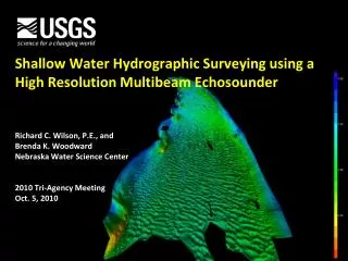
  16. Example Data from a High Resolution Underwater Scanning Sonar

More Related