Download
1 / 34
510 likes | 1.2k Vues
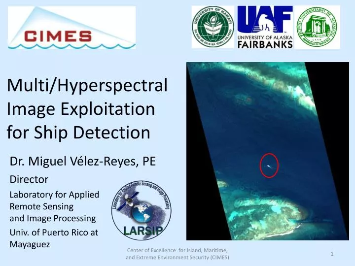
Multi/Hyperspectral Image Exploitation for Ship Detection. Dr. Miguel Vélez -Reyes, PE Director Laboratory for Appl ied Remote Sensing and Image Processing Univ. of Puerto Rico at Mayaguez. Spectral Imaging. Hyperspectral Imagery or Imaging Spectroscopy.

E N D
Multi/Hyperspectral Image Exploitation for Ship Detection Dr. Miguel Vélez-Reyes, PE Director Laboratory for AppliedRemote Sensing and Image Processing Univ. of Puerto Rico at Mayaguez Center of Excellence for Island, Maritime, and Extreme Environment Security (CIMES)
Hyperspectral Imageryor Imaging Spectroscopy Hyperspectral Imaging,also referred to as Imaging Spectrometry, combines: conventional imaging, spectroscopy, and radiometry to produce images for which a spectral signature is associated with each spatial resolution element (pixel). Information Extraction Algorithms for HSI should take advantage of spatial, spectral and temporal variability in the data.
Hyperspectral Imaging Satellite Sensors • Existing • HYPERION on board EO-1 satellite • CHRIS (Compact High Resolution Imaging Spectrometer) on board Proba (ESA, 2001) • AFRL/Raytheon TacSat 3 ARTEMIS (May2009) • DoD Situational Awareness • Proposed • Environmental monitoring • EnMAP (DLR, 2012). • SPECTRA (ESA, 2012). • HERO (Canadian, 2010), • HyspIRI (NASA, 2nd Tier Decadal Mission, 2013-16) • CIMES Small satellite network by UH • Space Exploration • NASA MRO Compact Reconnaissance Imaging Spectrometer for Mars (CRISM) , launched in 2005, http://crism.jhuapl.edu • Indian Space Research Organization Chandrayaan 1 • NASA Moon Mineral Mapper (M3) mission • ISRO Hyper Spectral Imager (HySI)
Hyperspectral for Ship Detection Zhang et al. 2004 Enrique Reef, PR 2007 AISA Mission Hypespectralimaging provides spectral and spatial information for improved ship detection.
Hyperspectral Imaging: Key Technology for Target Detection Spectral/spatial information is used to discriminate between background and target. UPRM is working on developing models and algorithms that take advantage of information in spectral and spatial domains Potential Targets HYDICE Image
Remote detection of ships using a hyperspectral remote sensing system (Images provided by R. Wright) 2m 30m 15 m Satellite HSI Airborne HSI Different levels of information that need to be taken into account during image exploitation Available HSI platforms represent different tradeoffs in spectral, spatial, and temporal domain Center of Excellence for Island, Maritime, and Extreme Environment Security (CIMES)
Remote detection of ships using a hyperspectral remote sensing system 2m 30m 15 m Satellite HSI Less Spatial/More Spectral Subpixel/Unmixing Ship wakes Ship Exhausts Airborne HSI Object Recognition Sea/Ship Contrast More Variability Center of Excellence for Island, Maritime, and Extreme Environment Security (CIMES)
Project Objective • Development of ship detection algorithms using hyperspectral imagery • Taking full advantage of spectral and spatial domain information • Use of ship signatures • Dealing with different spatial resolutions • HSI: Airborne (1-10m) and spaceborne ( 15-60m) • Object oriented versus subpixel approaches • MSI: submeter to kilometer Center of Excellence for Island, Maritime, and Extreme Environment Security (CIMES)
Typical Target Detection and Recognition System • Preprocessing • (e.g. Denoising) • Dimension Reduction • Identification • Anomaly Detection(e.g. RX) Semi-submersible Vehicle from Colombia Drug Smugling Spectral + Spatial Signatures 128 106 99
Ship Detection in MODIS Imagery Ms. L.P. Dorado, Research Associate Prof. M. Velez-Reyes Center of Excellence for Island, Maritime, and Extreme Environment Security (CIMES)
MODIS Sensor: MODIS Moderate resolution Imaging Spectroradiometer Complete daily coverage of the earth. 36 Spectral bands 0.4 -14.4 µm Three different spatial resolutions: 250 m, 500 m, and 1 Km. The images in reflectance and radiance are available.
Why? • NOAA NPOESS: National Polar-orbiting Operational Environmental Satellite System • 100 minutes revisit times • Replaces DMSP and POES satellite series • VIIRS sensor • 400/800m resolution • Follow on to the MODIS sensor Center of Excellence for Island, Maritime, and Extreme Environment Security (CIMES)
Remote detection of ships in MODIS Imagery 15 m 10m 40m 500m Challenge: Very Low Spatial Resolution Center of Excellence for Island, Maritime, and Extreme Environment Security (CIMES)
Ship Detection in MODIS Traces of ship emissions in clouds. Porch, et al. 1990, Flemming et al. 1994, Spectral contrast between ship and water. Subpixel detection Center of Excellence for Island, Maritime, and Extreme Environment Security (CIMES)
Detection of Ship Emissions Spectral Characterization MODIS Image Target Detection Endmember Extraction and Comparison Region of Interest
Experiments with MODIS Images: Region under Consideration
Endmember Extraction-Comparison Correlation Matrix Spectral Signatures Endmembers
Target Detection: OSP Detector Threshold 0.82 Target: endmember 3 Background: endmembers 1, 2 Binary Image Threshold= 0.82
Subpixel Ship Detection Region 1 Region 2 Region 3
Spectral Characterization: Region 3
Endmember Extraction-Comparison Correlation Matrix Spectral Signatures Endmembers
Target Detection: OSP Detector Region 1 Threshold 0.37 Target: endmember 1 Background: endmembers 2
Target Detection: Region 2 Region 3 Target: endmember 1 Background: endmembers 2 Threshold 0.37
Diffusion Methods for Enhancement of Multi/Hyperspectral Images Ms. M. Marin-McGee, Ph.D. Candidate Prof. M. Velez-Reyes Center of Excellence for Island, Maritime, and Extreme Environment Security (CIMES)
Enhancement using Diffusion Methods Center of Excellence for Island, Maritime, and Extreme Environment Security (CIMES)
Enhancement of Flow Structures: Coherence Enhancement Center of Excellence for Island, Maritime, and Extreme Environment Security (CIMES)
Edge Enhancement DiffusionHYDICE Forrest Radiance Edge Enhanced Original Center of Excellence for Island, Maritime, and Extreme Environment Security (CIMES)
Wrong Enhancement may not be Effective Coherence Enhanced Original Center of Excellence for Island, Maritime, and Extreme Environment Security (CIMES)
Some detection problems require both enhancements simultaneously Hybrid diffusion Combining CED EED
Progress Summary • Studied ship detection in MODIS imagery as a model for VIIRS in NPOESS • Potential for operational system 100 min revisit time • Indirect detection and subpixel approaches • Need development of spectral libraries • Showed initial results on enhancement using diffusion methods. • CED and EED can be used for enhancing different structures in the image flow versus edges • Hybrid methods are being proposed for simultaneous edge and flow structure enhancement Center of Excellence for Island, Maritime, and Extreme Environment Security (CIMES)
Proposed Work for Yr 2.5-4 • Enhancement of Multi/Hyperspectral imagery using diffusion methods • Hybrid diffusion • Integration of spectral/spatial information for ship detection • Testing and validation of detection algorithms using available data Center of Excellence for Island, Maritime, and Extreme Environment Security (CIMES)
Thanks for your attention Miguel Velez-Reyes UPRM LARSIP P.O. Box 3535 Marina Station Mayaguez, PR 00681 Ph. 787-832-2825 Fax 787-832-2485 E-mail: m.velez@ieee.org Center of Excellence for Island, Maritime, and Extreme Environment Security (CIMES)