Download
1 / 28
280 likes | 423 Vues
HISTORICAL GEOLOGY LECTURE 5. STRUCTURE OF THE EARTH, OROGENESIS, CONTINENTAL GROWTH BY ACCRETION.

E N D
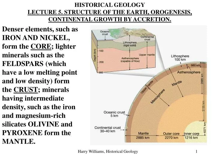
HISTORICAL GEOLOGY LECTURE 5. STRUCTURE OF THE EARTH, OROGENESIS, CONTINENTAL GROWTH BY ACCRETION. Denser elements, such as IRON AND NICKEL, form the CORE; lighter minerals such as the FELDSPARS (which have a low melting point and low density) form the CRUST; minerals having intermediate density, such as the iron and magnesium-rich silicates OLIVINE and PYROXENE form the MANTLE. Harry Williams, Historical Geology
Even after 4 billion years of cooling, the outer core remains molten and part of the upper mantle is partially molten and capable of flowing very slowly. Elements Of The Crust And Upper Mantle Continental crust: averages about 35 km thick. Rich in feldspars and "granitic" rocks. Harry Williams, Historical Geology
Oceanic crust: 5-12 km thick. Rich in iron and magnesium - basalt rock. Upper mantle: the uppermost part of the mantle (to approx. 100 km deep) is solid. This part of the mantle together with the overlying crust is the LITHOSPHERE. The Asthenosphere: this part of the mantle, between about 100 and 700 km deep, is partially molten and capable of flowing very slowly. Plate motion may be driven by convection here. Harry Williams, Historical Geology
Continental crust can be divided into 4 regions: a) Shields: old, precambrian metamorphic and igneous rocks at the "core" of continents. b) Platforms: adjacent to shields, similar rocks; covered by newer sedimentary rocks formed during transgressions (shield + platform = craton). c) Orogenic belts, usually around the edge of the continents, severely deformed due to plate collision. Orogenic = "mountain-building". d) Passive margins, the trailing edge of continents; little or no tectonic activity. Coastal plains. Harry Williams, Historical Geology
The craton tends to be very stable, but has undergone broad warping in the past - especially in platform areas, creating basins, domes and tilted strata. View of the Canadian Shield Harry Williams, Historical Geology
Platforms Platforms are parts of the craton which are covered by relatively undeformed layers of sedimentary rock, formed when seas occupied these areas (due to tilting/sinking of the craton or rise in sea level). A large part of the interior of North America consists of platform areas. Structure within the platform rocks is usually quite subdued: however, many parts of platforms are not completely flat; instead broad warping of the underlying craton has produced gently tilted beds (< 5o), domes (e.g. the Black Hills of Dakota; Ozark Mountains of Missouri) and basins (e.g. Michigan Basin). Harry Williams, Historical Geology
An exception to the generally subdued structure of platforms, resulting from plate movements, is intracratonic rifting which forms rift valleys, seas and aulacogens in platform regions. Red Sea rift(view to the south) Harry Williams, Historical Geology
A relatively new idea in plate tectonics suggests that rifting may actually be initiated by hot spots which cause the continental crust to dome up and split into a triple rift. Commonly, one of the rift arms fails, while the other two become active and contribute to an opening linear ocean basin. So the convection cell that drives sea-floor spreading may actually be a line of "hot spots". Harry Williams, Historical Geology
The rift valley forms a large linear trough, bounded by fault scarps and floored by volcanic rocks. If the valley extends below sea level, it becomes the site of sedimentation. Harry Williams, Historical Geology
The failed arm, represented by a deep linear trough into the adjacent continent, may become a natural location for a major river valley within platform areas - probable examples include the Mississippi and the Amazon. Harry Williams, Historical Geology
It is also possible for a failed arm of a rift to become "squeezed shut" by later plate movements - forming an aulacogen. The Arbuckle Mountains lie on the northeastern margin of the southern Oklahoma aulacogen. Closure of the aulacogen resulted in severe folding and faulting of marine sedimentary rocks which had accumulated in the trough - one of the few places that platform strata are so deformed. Harry Williams, Historical Geology
PLATE TECTONICS We are concerned primarily with plate collision and orogenesis: Harry Williams, Historical Geology
Orogenic Belts In the case of North America there are three major orogenic belts - the older Appalachian and Ouachita chains in the east and south, and the much younger Rockies in the west. All were formed by plate convergence and have similar structural features. All three areas underwent uplift, metamorphism, volcanism, folding, thrust faulting and later erosion. Appalachians Rockies Ouachitas Harry Williams, Historical Geology
OROGENESIS AT CONVERGENT BOUNDARIES 1. Passive Margins: prior to orogenesis, the continental boundary is a PASSIVE margin. Sedimentation at passive margins reflects the progressive increase in water depth. Nearshore deposits are coarser - sand grading to silt and clay; further out on the continental shelf in clean shallow water, carbonates form in tropical regions. A common feature of continental margins undergoing extensive sedimentation is SUBSIDENCE, due to the weight of sediment ISOSTATICALLY DEPRESSING the crust; in this way shallow water deposits (e.g. 100’ depth) can build up thicknesses of 1000's of feet. Harry Williams, Historical Geology
Andean-Type Orogenesis 1. Passive stage (pre-convergence) -> marginal deposits form. hills mountains cliffs ridges Harry Williams, Historical Geology
valleys 2. early subduction -> marginal deposits are deformed by compression. Folds and thrust faults are formed. 3. Volcanic arc forms. 4. Lateral growth by accretion; emplacement of igneous masses; metamorphism; further deformation of marginal deposits. canyons deltas beaches Harry Williams, Historical Geology
5. Continued uplift and deformation results from continuing plate convergence. Examples = Andes of western south America; Rockies of North America. Harry Williams, Historical Geology
The Sierra Nevada and the Coast Range are good examples of Andean-type orogenesis. The Sierra Nevada batholith is a remnant of a continental volcanic arc. The Coast Range consists of accretionary wedge sediments that have been deformed and uplifted by plate convergence (Note: the subduction zone between the Pacific and North American plates that formed these features has since changed into a transform fault – the San Andreas). Harry Williams, Historical Geology
Continental Collision-Type Orogenesis About 20 million years ago - India was separated from Asia by a progressively narrowing ocean basin - the Tethys Sea. The “collision” begun with the subduction of the oceanic plate beneath the Tethys Sea. This caused the onset of orogenesis in Tibet (uplift, folding, faulting, metamorphism, volcanism). Initial growth was similar to Cordilleran-type orogenesis; however, when the continents collide one of them can not be subducted (too thick and buoyant), therefore the plates are welded together forming a SUTURE ZONE and producing a large mountain chain, containing sedimentary, igneous and metamorphic rock. 17.23a Harry Williams, Historical Geology
The period of mountain building is termed an OROGENY. The Himalayas are very high because they are very young (geologically). Uplift continues and erosion hasn’t had long to wear the mountains down. Harry Williams, Historical Geology
Suture zones usually have symmetrical patterns of rock types (folded sedimentary, metamorphic, granite) and the high rugged mountains resulting from orogenesis are subject to intense erosion, shedding sediment to both sides of the mountain range. sediment sediment Harry Williams, Historical Geology
The present-day relief of mountain belts is a result of erosion: in North America, the Appalachians being much older than the Rockies are more subdued and lower and consist mainly of exposed and eroded folds. Appalachians Rockies Harry Williams, Historical Geology
folds Harry Williams, Historical Geology
Young mountain belts like the Rockies are higher and more rugged. Fault block mountain ranges are also common UPLIFT Harry Williams, Historical Geology
The Grand Tetons of Wyoming are an example of a block of crust uplifted along a fault. faults Harry Williams, Historical Geology
All orogenies have common features: 1. compression, buckling and uplift at the edge of the continent. 2. emplacement of igneous rock masses 3. folding, faulting and metamorphism 4. erosion of the growing mountains and deposition adjacent to the mountains (including the back-arc basin). 5. scraping off, folding and uplift of sea floor rock and sediments onto the edge of the continent - resulting in: sediment Harry Williams, Historical Geology
Continental Growth By Accretion Caused by the "plastering on" of material at the edge of a continental plate adjacent to a subduction zone. The material that accumulates in this fashion can be small continental masses MICROCONTINENTS or oceanic features such as volcanic arcs and seamounts (submarine volcanoes). The Seychelles Bank in the Indian Ocean is an example of a microcontinent, which has apparently become detached from Africa. These larger masses of rock are scraped off the subducting plate and plastered onto the continent to form ALLOCHTHONOUS or EXOTIC TERRANES (meaning they originated elsewhere). Harry Williams, Historical Geology
Example: Wrangellia consists of basaltic island arc volcanic rocks, deep marine shales and shallow marine limestones. This material originated in the area presently around New Guinea in Triassic time (225 million years ago) - travelling about 10,000 km to its present location. The collision of these smaller masses with the larger continent also causes orogenic activity, resulting in coastal mountain ranges. Harry Williams, Historical Geology