Download
1 / 1
10 likes | 126 Vues
Implementing GIS for Expanded Data Accessibility and Discoverability. Brandi Quam, Matthew Tisdale, Emily Northup, & John Kusterer NASA Langley Research Center, Hampton, VA.

E N D
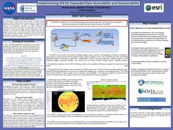
Implementing GIS for Expanded Data Accessibility and Discoverability Brandi Quam, Matthew Tisdale, Emily Northup, & John Kusterer NASA Langley Research Center, Hampton, VA The ASDC is piloting the use of GIS technology to provide the GIS user community with new ways to discover and access the large volumes of data housed at the ASDC. • Investigate web applications that can leverage geospatial datasets and services for increased access to NASA ASDC data holdings and exercise Esri analytic tools to integrate GIS capabilities into an advanced data architecture that utilizes emerging tools and technologies • Investigate mobile applications that can leverage the geospatial datasets and services for increased access to NASA ASDC data products in the field and that take advantage of unique mobile platform capabilities • Integrate geospatial analysis capabilities and tools into the ASDC • Register metadata with Geospatial Platform, Data.gov and NASA REVERB | EOS Clearinghouse (ECHO). This will enable discovery of GIS services made available by the ASDC. WCS ArcGIS for Server WMS Open Source (World Wind, QGIS) Commercial (ArcGIS for Desktop) Publisher In 2012, the ASDC facilitated the development of the first ever strategic plan intended for fiscal year 2013 and beyond. The 2013 Strategic Plan serves as a mission-focused plan with six defined goals, each with supporting objectives and tasks for implementation that emphasize the vision and support the mission and values of the ASDC. 1. The ASDC archives data in the areas of radiation budget, clouds, aerosols, and tropospheric chemistry. Examples of data products include several from the NASA Langley satellite programs such as the Cloud-Aerosol Lidar and Infrared Pathfinder Satellite Observations (CALIPSO), Stratospheric Aerosol and Gas Experiment (SAGE) missions, Earth Radiation Budget Experiment (ERBE), and Clouds and the Earth's Radiant Energy System (CERES) program. 2. The publisher’s machine uses ArcGIS for Desktop, which is only available on Windows, to publish the map built off of the ASDC data. 3. The ArcGIS for Server machine is set to reference the ASDC data as well. ArcGIS for Server provides integrated server-based GIS through applications and services for spatial data management, visualization, and spatial analysis. The ASDC data and the ArcGIS for Server reside on linux machines running SAMBA. This allows the publishers machine and the server to all reference the same data so that it is not copied over when the map is published. Goal #1 The ASDC will strive to expand beyond its existing customer base by increasing accessibility to a broader, worldwide market; through the use of innovative technologies, the ASDC will enhance data access capabilities and develop plans to share data with new user communities. Pursuant to this goal, the ASDC is exploring and piloting new technologies to implement for enhanced data access capabilities. Of the technologies being explored and piloted includes Geographic Information Systems (GIS). Through the implementation of GIS using Esri software, NASA’s Atmospheric Science Data Center (ASDC) intends to expand the discovery and access to ASDC data. 4. A Web Map Service (WMS) is generated by ArcGIS for Server after publishing. A WMS is a standard protocol for serving georeferenced map images over the Internet that are generated by a map server using data from a GIS database. ArcGIS for Desktop using WCS , NASA World Wind using WMS 1 6 2 7 4 5 3 5. After publishing, a Web Coverage Service (WCS) is also generated by ArcGIS for Server. The WCS defines Web-based retrieval of coverages – digital geospatial information that represents space/time-varying phenomena. ASDC Data 6. The ASDC is utilizing commercial GIS applications, such as ArcGIS for Desktop, to test WMS and WCS Services in order to ensure data integrity as well as the speed and reliability of the services are maintained. 7. The ASDC is also utilizing open source GIS applications, such as NASA World Wind and Quantum GIS, in order to test services to ensure they respond the same as they do through commercial GIS applications.